
Slieve Gullion facts for kids
Quick facts for kids Slieve Gullion |
|
|---|---|
| Sliabh gCuillinn | |

Slieve Gullion from Aughanduff
|
|
| Highest point | |
| Elevation | 573 m (1,880 ft) |
| Prominence | 478 m (1,568 ft) |
| Listing | County top (Armagh), Marilyn |
| Naming | |
| English translation | mountain of the steep slope |
| Language of name | Irish |
| Geography | |

Slieve Gullion
Location in Northern Ireland

Slieve Gullion
Location in island of Ireland

Slieve Gullion
Location in the United Kingdom
|
|
| Location | County Armagh, Northern Ireland |
| Parent range | Ring of Gullion |
| OSI/OSNI grid | J024201 |
Slieve Gullion is a famous mountain in the south of County Armagh, Northern Ireland. Its name comes from the Irish words Sliabh gCuillinn, which means "hill of the steep slope" or "Culann's mountain."
This mountain is the highest point in County Armagh, standing at 573 metres (1,880 ft) tall. It is also the main part of the beautiful Ring of Gullion area. At the very top of Slieve Gullion, you'll find a small lake and two very old burial mounds called cairns. One of these is the highest surviving passage grave in all of Ireland!
Slieve Gullion is a special place in Irish mythology. Many old stories connect it to the Cailleach (an ancient goddess) and famous heroes like Fionn mac Cumhaill and Cú Chulainn. From the top, you can see amazing views across the countryside. On a clear day, you might even see as far as Antrim, Dublin Bay, and Wicklow. On the eastern side of the mountain, there is a fun place called Slieve Gullion Forest Park.
The villages around Slieve Gullion include Meigh, Drumintee, Forkhill, Mullaghbawn, and Lislea. The mountain is so important that it gives its name to the whole area. It is also the name of an election area within the Newry, Mourne and Down District Council.
Geography of Slieve Gullion

Slieve Gullion is a mountain with steep sides and a flat top. It stands 573 metres (1,880 ft) high. This mountain is actually what's left of a very old volcano that erupted a long, long time ago. It is surrounded by a special circular rock formation called a ring dike. This area is known as the Ring of Gullion and is a protected Area of Outstanding Natural Beauty (AONB).
Slieve Gullion was shaped by huge sheets of ice, called glaciers, in the past. It has a classic 'crag and tail' shape, which is formed by glaciers. The 'tail' is made of rocks and dirt left behind by the ice. It points south towards Drumintee. Scientists first studied this unique rock formation here. The rocks in this area are very complex and have been important in geology discussions worldwide since the 1950s. Geologists from all over the world come to study Slieve Gullion. Some of the ideas that came from studying this mountain are now accepted facts in geology.
Most of Slieve Gullion is covered with trees, heather, or bare rock. A large area of dry heathland on the mountain, about 612 hectares, is a Special Area of Conservation. It is also an Environmentally Sensitive Area and an Area of Outstanding Natural Beauty. In 2006, some areas of gorse bushes were burned in a wildfire. This fire may have been started on purpose.
You can still see signs of old fields on the mountain. People used to farm here, even though the soil was poor. There is also proof that people used to dig for stone in quarries on the mountain.
Ancient Burial Mounds

There are two ancient burial mounds, called cairns, on top of Slieve Gullion. They are located on either side of a small lake. The one on the southern side is a very large passage tomb. It is the highest passage tomb still standing in Ireland.
In 1961, a group of archaeologists explored this site. They set up a camp with 30 people near the top of the mountain. The burial mound is about 30 metres (98 ft) wide and 5 metres (16 ft) high. Inside, the main room is 3.6 metres (12 ft) wide. Its roof is built with stones that stick out, reaching up to 4.3 metres (14 ft) high. Inside the tomb, archaeologists found three large stone blocks that looked like basins. They also found small pieces of human bone. Some worked flint tools and an arrowhead were also discovered. These were the few things that remained after many years of people disturbing the tomb.
The entrance of this tomb lines up perfectly with the setting sun on the shortest day of the year, the winter solstice. Scientists believe it was built between 3500 and 2900 BCE. The smaller mound, north of the lake, was built later, perhaps during the Bronze Age. It holds two cist burials, which are stone boxes for burials. One of these contained small pieces of burnt bone, likely from one adult.
During World War II, American soldiers training here disturbed these two mounds. Old Irish stories say it's bad luck to damage or disrespect such ancient tombs. People believe it could bring a curse. Today, these mounds are protected by law as historic monuments. In recent years, volunteers have helped to fix the burial mounds. They worked under the guidance of an archaeologist.
Exploring Slieve Gullion
Slieve Gullion is a popular place for people who enjoy hillwalking. About 20,000 people climb the mountain every year. There is a road that goes halfway up the western side of the mountain, where you'll find a small parking lot. From there, a path leads to the very top. There is also another marked path from the northern side of the mountain.
Sometimes, cars parked on the mountainside are broken into by thieves. The police have asked visitors not to leave valuable items in their cars.
On the eastern side of the mountain is Slieve Gullion Forest Park. This park has a visitors' center, a café, and a playground. It also features a fun place called the Giant's Lair Story Trail, which is great for families.
Myths and Legends of Slieve Gullion
Slieve Gullion is a very important place in Irish mythology. Many exciting stories are set here.
Fionn and the Cailleach
In a story called The Hunt of Slieve Gullion, two sisters, Áine and Milucra, both wanted the famous hero Fionn mac Cumhaill (Finn McCool). Áine had promised she would never marry a man with grey hair. Milucra secretly put a magic spell on the lake at the top of Slieve Gullion. The spell made anyone who swam in the lake become old.
Milucra tricked Fionn by asking him to get her golden ring from the lake. When Fionn came out of the water, he was an old man with grey-white hair! His group of warriors, the Fianna, made Milucra give him a special drink from her magic horn. Fionn became young again, but his hair stayed white. This is said to be how he got his name, Fionn, which means 'white'. In some versions of the story, Milucra is actually the Cailleach Bhéara (Calliagh Birra), a very old goddess.
Many places on the mountain are named after the Cailleach Bhéara. The passage tomb is called Calliagh Birra's House. The small lake is known as Calliagh Birra's Lough. Lower down, on a small hill called Spellick, there is a rock formation called the Calliagh Birra's Chair. Local people used to visit this chair during the Lughnasadh festival and take turns sitting on it.
Cú Chulainn's Story
Slieve Gullion is also said to be the place where the legendary hero Cú Chulainn (Cuhullin) got his famous name. It is also where he spent his childhood as Sétanta.
According to the myth, the mountain is named after Culann the metalsmith. Culann invited Conchobhar mac Neasa, the king of Ulster, to a feast at his house on Slieve Gullion. On his way, King Conchobhar stopped to watch boys playing hurling. He was so impressed by Sétanta's skills that he asked him to join the feast. Sétanta promised to come after his game.
Conchobhar went ahead, but he forgot about Sétanta. Culann then let out his fierce guard dog to protect his house. When Sétanta arrived, the dog attacked him. But Sétanta was incredibly strong and killed the dog. In one story, he smashed it against a standing stone. In another, he hit a sliotar (hurling ball) down its throat with his hurley.
Culann was very sad about losing his dog. So, Sétanta promised to raise a new guard dog for him. Until the new dog was old enough, Sétanta himself would guard Culann's house. The wise druid Cathbhadh then announced that Sétanta's new name would be Cú Chulainn, which means "Culann's Hound."
In the famous story Táin Bó Cuailnge, the nearby Gap of the North is where Cú Chulainn bravely fought off the army of Queen Méabh all by himself.
Images for kids
-
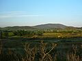
Slieve Gullion at dusk from the west.
-
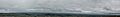
A 360-degree panorama of Ireland seen from Slieve Gullion.

