Ring of Gullion facts for kids
Quick facts for kids Ring of Gullion |
|
|---|---|
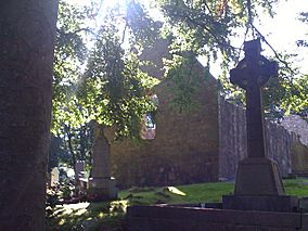
Ruins of the early Christian Killeavy old Church
|
|
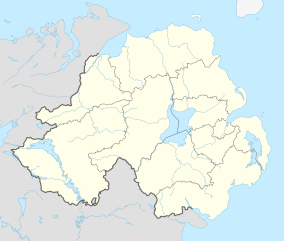
| Location | County Armagh, Northern Ireland |
| Area | 152.39 km2 (58.84 sq mi) |
| Established | 1991 |
| Governing body | Department of Environment |
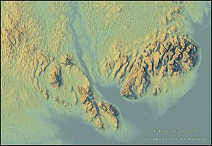
The Ring of Gullion is a special area in County Armagh, Northern Ireland. It's known for its unique geology and beautiful scenery. This area is officially called an Area of Outstanding Natural Beauty (AONB). It gets its name from Slieve Gullion, which is the highest mountain in County Armagh.
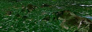
The Ring of Gullion covers about 150 square kilometers (about 58 square miles). It's shaped by the hills of an ancient "ring dyke." A ring dyke is a circular rock formation that forms when magma (molten rock) pushes up through cracks in the Earth. Parts of this area are also protected as Areas of Special Scientific Interest because of their unique features.
Geologists first mapped this ring dyke a long time ago. However, they didn't fully understand how important it was until similar structures were found in Scotland. This amazing geological feature was formed during the Palaeogene period, which was about 66 to 23 million years ago. This was when the Atlantic Ocean started to open up.
Contents
How the Ring of Gullion Was Formed
The Ring of Gullion has a very interesting past! Its unique shape comes from a huge, ancient volcano. When this volcano was active, its top part, called a caldera, collapsed. This collapse created circular cracks in the ground. Magma then squeezed into these cracks, forming the "ring dyke" we see today.
The rocks here are a mix of different types, like granophyre and felsite. The main part of the old volcano is now made of rocks called gabbro and granophyre. Scientists have even found rare elements like platinum here!
A Long and Complex History
The rocks in the Ring of Gullion are very complex. Geologists from all over the world have studied them since the 1950s. They've tried to figure out how these unusual rocks got here. Some of their ideas have even become important parts of how we understand geology today.
One of the biggest puzzles is how different forces shaped this area. Some rocks are from the Silurian period, over 400 million years ago, when this land was part of an ancient ocean. Then, volcanoes erupted, adding huge amounts of molten rock (magma). This magma cooled to form the bedrock under places like Newry town and Slieve Gullion. These rocks are about 390 million years old.
More volcanic activity happened about 66 million years ago. Scientists believe that a very large volcano once stood here, but most of it is gone now. Other volcanoes also erupted in the south of the area. You can still find remains of these old volcanoes, called "volcanic necks," in the hills around Forkhill.
The Ring Dykes and Slieve Gullion
As the land changed, circular cracks formed between the older rocks and the newer volcanic rocks. Hot, liquid rock (lava) flowed into these cracks. When it cooled, it formed very hard rocks like granophyre and felsite. These are the two "ring dykes" that create the "outer" and "inner" rings of the area.
Slieve Gullion mountain itself is actually newer than these ring dykes. It's made up of layers of volcanic rock. Some scientists think a huge, explosive eruption created a giant crater, and then lava flowed out in layers. Another idea is that the lava simply flowed out in layers over time. There are also many unusual features where different types of molten rock mixed together.
Shaped by Ice
After all the volcanic activity, glaciers played a big role in shaping the Ring of Gullion during several Ice Ages. Glaciers are like giant rivers of ice. They carved deep valleys by pushing through weaker rocks and cracks. They also scraped over hills, leaving behind rocky outcrops, slopes covered in boulders, and jagged ridges. In the valleys, rounded hills called drumlins were formed. For example, the "tail" of Slieve Gullion, near Dromintee, is a ridge of clay and boulders left behind by ice moving from the north.
Natural Wonders to Explore
Besides Slieve Gullion and its rocky ring, the area has many beautiful lakes and parks.
Slieve Gullion Forest Park
Slieve Gullion Forest Park is a great place to visit! It has many acres of natural and planted forests. There's an eight-mile scenic drive that offers amazing views of the Ring of Gullion, the Mourne Mountains, and the Cooley Peninsula. On a clear day, you can even see as far south as Wicklow!
There's also a marked trail that takes you almost halfway up the mountain to the summit. This path leads to ancient stone cairns (piles of stones) on top of the mountain and a lake. At the Courtyard Centre, you can find refreshments, a garden, and restrooms.
Camlough Lake
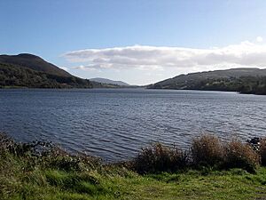
Camlough Lake is also known as Camloch, which means "Crooked Lake" in Irish. It was formed by glaciers and got its name from its uneven shape. Even though it doesn't look very crooked today, it was much more irregular before a dam was built in the late 1800s. This lake sits in a valley between Slieve Gullion and Camlough Mountain. It's the biggest lake in the Ring of Gullion.
Near the lake, there's a long tunnel, about one kilometer (0.6 miles) long. It's wide enough for a large truck! This tunnel was dug in the 1960s for a project to create a huge underground cavern inside Camlough Mountain. The plan was to use it to store and release water to make electricity. This "pumped hydro storage scheme" could have generated over 200 megawatts of power. However, the plans were put on hold due to local unrest at the time.
Cashel Lakes
The Upper and Lower Cashel Lakes, along with Carrigans Lough, are beautiful lakes high up in the hills. Their water is very clean and unpolluted. These lakes are home to many different kinds of insects, including 30 species of water beetles, 15 species of spiders, and 10 species of ground beetles.
Rich Cultural Heritage
The Ring of Gullion is full of old Irish legends and myths! You can find many ancient sites here that date back to before Christianity and even before the Normans arrived.
In the famous story Táin Bó Cuailgne (the Cattle Raid of Cooley), the hero Cú Chulainn is said to have defended Ulster all by himself against the army of Queen Maeve of Connacht. This battle supposedly happened at the Gap of the North, which is in the southern part of the Ring of Gullion.
Another tale tells of Fionn Mac Cumhaill, a legendary warrior. He was tricked by a sorceress named Miluchra on top of Slieve Gullion. She turned him into an old, weak man. Even though he managed to break the spell, his hair stayed white forever. To this day, some people believe that if you swim in the lake on Slieve Gullion, your hair will turn white!
People have lived in the Ring of Gullion for at least 6,000 years. There are many ancient monuments that show how long people have been here. The area has about 20 large stone tombs. The King's Ring at Clontygora and the Ballymacdermot tomb are excellent examples of "Court Tombs" in Northern Ireland. The monument at Ballykeel is a great example of a "Portal Tomb." The South Cairn on top of Slieve Gullion is special because it's the highest "Passage Tomb" still standing in Britain or Ireland.
In the 1700s, which was a golden age for Irish language literature, the Ring of Gullion was known as the "District of Poets" or "District of Songs." Famous poets from this area included Séamus Mór Mac Mhurchaidh, Art Mac Cumhaigh, and Peadar Ó Doirnín.
Here are some important cultural and historical sites in the area:
The Dorsey
The Dorsey is an ancient earthwork from the Iron Age. Its name comes from the Irish word Doirse, meaning "Doors" or "gates." It's located at Dorsey, on the western edge of the Ring of Gullion. This structure has two long, parallel earth banks and ditches, over a mile long. They sit across an old road that led to Eamhain Macha (Navan Fort), which was the ancient capital of Ulster.
Recent discoveries show that parts of the Dorsey are about 100 BC old. This was around the same time as a lot of activity at Navan Fort. This supports the idea that the Dorsey was once the "gateway" to Ulster. What the Dorsey was used for is still debated. Some think it was a defensive wall, while others believe it was just two lines of banks, not an enclosed area. Some even think it had a special religious purpose. Its true use is still a mystery!
Kilnasaggart Stone
The Kilnasaggart Stone is a tall stone pillar, about 2.8 meters (9 feet) high. Its name, Cill na Sagart, means "Church of the Priests" in Irish. This stone might be the oldest dated stone monument in Ireland!
An inscription on the stone says that Ternoc, son of Cernan Bic, placed the area under the protection of Peter the Apostle. Since Ternoc's death is recorded around 714 or 716 AD, the stone can be dated to about 700 AD.
The stone marks an early Christian cemetery. There was probably a church nearby, founded in the 5th century. It was originally called Domnach Culind (Gullion Church). An 11th-century text says that the poet Eóchaid Rígéices is buried here. In the 1960s, excavations at the site found an early Christian graveyard with graves arranged in a circle around the pillar, facing the rising sun. The stone stands on an ancient road that ran from Tara in County Meath, through the Moyry Pass, all the way to Dunseverick Head on the North Antrim Coast. It's also very close to the modern border between Northern Ireland and the Republic of Ireland.
Killevy Churches
The Killevy Churches are located at the foot of Slieve Gullion. Their name, Cill Shléibhe, means "Mountain Church" in Irish. This site was one of the most important early Christian monasteries in Ireland. It was founded by St Monnina in the 5th century.
Today, you can see two churches next to each other, a graveyard, what is believed to be St Monnina's grave, and a small holy well. Pilgrims still visit the well on her feast day, July 6. The West Church dates from the 11th century. It's smaller and older, with an impressive doorway. The East Church is from the 15th century and has a beautiful arched window with angel carvings that you can still see.
Even after being attacked by the Vikings in 923, monastic life continued here. Augustinian Nuns lived at the site until 1542, when the monasteries were closed down.
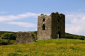
Moyry Castle
Just south of Jonesborough is a very important mountain pass called Moyry Pass, or the "Gap of the North." In 1601, Lord Mountjoy built Moyry Castle on a rocky outcrop above this pass. He built it a year after capturing the area for the crown.
This pass was the most popular ancient route between the provinces of Ulster and Leinster. It was said to be the widest path an army could use while under attack. The castle is now in ruins. It was built as a three-story tower with rounded corners and holes for guns. You can clearly see it from the modern railroad line, which was built in 1852.
The area around the castle is still mountainous and boggy, though it's not as heavily wooded as it once was. Not much is left of the stone wall that used to surround the castle, except for one section to the southeast.
Local Communities
Most of the Ring of Gullion is located within the old area of Orior Upper in County Armagh. It is also part of the Newry, Mourne and Down District Council.
Places in the Ring of Gullion area
- Altnaveigh
- Aughanduff
- Belleeks
- Bessbrook
- Camlough
- Corrinshego
- Dorsy
- Dromintee
- Fathom
- Forkill
- Jonesborough
- Killeen
- Lislea
- Meigh
- Mullaghbawn
- Newtowncloghoge
- Silverbridge
Special Status and Protection
The Ring of Gullion was officially named an Area of Outstanding Natural Beauty (AONB) in December 1991 by the Department of Environment. This means it's a special place recognized for its beautiful landscapes and natural importance.
The AONB area includes the main mountain ring and its slopes. It also extends west to include the famous Dorsey Enclosure. To the west, it includes the valleys of the Cully Water and Umeracam River, which separate the ring dyke hills from the rolling drumlin landscape towards Crossmaglen and Cullyhanna. In the northwest, the ring dyke goes through the higher ground of the Fews, where you can see sharp, rocky hills with unique heath plants. To the east, its border is the Newry Canal and the Newry River, which flows towards Carlingford Lough.
In June 1994, the countryside of the Ring of Gullion was also named the Slieve Gullion Environmentally Sensitive Area (ESA). This program, run by the Department of Agriculture and Rural Development, encourages farmers to use methods that help protect and improve the landscape, wildlife, and history of their land. Farmers who join this voluntary scheme receive financial support.
How the Ring of Gullion is Managed
The Ring of Gullion is looked after by the Ring of Gullion Partnership. This group has staff who work to carry out a special plan to manage and protect the area. This management is funded by different organizations, including the Northern Ireland Environment Agency (NIEA), Newry, Mourne and Down District Council (NMDDC), and the Heritage Lottery Fund.
Getting There
You can reach the Ring of Gullion easily by road. The M1 / A1 motorway passes through the eastern part of the area, with several exits near Newry and Dundalk.
You can also travel by train. Both NI Railways and Iarnród Éireann have services to Newry and Dundalk. The Enterprise train also stops at both Dundalk railway station and Newry railway station.
 | Laphonza Butler |
 | Daisy Bates |
 | Elizabeth Piper Ensley |


