
Mourne Wall facts for kids

The Mourne Wall (called Balla an Mhúrn in Irish) is a very long stone wall in the Mourne Mountains in Northern Ireland. It was built to surround an area that collects water for a big reservoir. The wall was constructed between 1904 and 1922 by the Belfast City and District Water Commissioners. They needed to make sure the city of Belfast had enough clean water.
Contents
Why Was the Wall Built?
In 1874, an engineer named Luke Livingstone Macassey started working for the Belfast Water Commissioners. This group was set up in 1840 to provide water for Belfast, which was growing fast. By 1891, Macassey suggested building a large reservoir in the Mourne Mountains. This was a long-term plan to keep Belfast supplied with water.
To build the reservoir, they needed to get permission to use the land and its water. Special laws were passed in 1893, 1897, and 1899 to allow the Commissioners to do this.
The Silent Valley Reservoir was created to hold the water. The main reason for the Mourne Wall was to keep farm animals like cows and sheep out of the water collection area. This helped keep the water clean. Today, Northern Ireland Water owns and looks after the wall.
How the Wall Was Built and Where It Goes
The Mourne Wall was made from natural granite stones. Builders used a traditional method called dry stone walling, which means no cement or mortar was used. The stones are carefully fitted together.
The wall is usually about 1.5 meters (5 feet) high and 0.8 to 0.9 meters (about 3 feet) thick. It is estimated to be about 19.5 miles (31.4 kilometers) long! It crosses over fifteen mountains. Imagine walking that far!
Here are the mountains the wall crosses, listed clockwise from the Kilkeel River:
- Slievenaglogh (445 meters high)
- Slieve Muck (674 meters high)
- Carn Mountain (587 meters high)
- Slieve Loughshannagh (619 meters high)
- Slieve Meelbeg (708 meters high)
- Slieve Meelmore (680 meters high)
- Slieve Bearnagh (739 meters high)
- Slievenaglogh (586 meters high)
- Slieve Corragh (641 meters high)
- Slieve Commedagh (765 meters high)
- Slieve Donard (850 meters high)
- Rocky Mountain (525 meters high)
- Slieve Binnian (747 meters high)
- Wee Binnian (460 meters high)
- Moolieve (332 meters high)
The Mourne Wall Challenge Walk
The Mourne Wall Challenge is a very tough walking route. It follows the historic Mourne Wall over 7 of the 10 highest mountains in the Mournes. It's a popular personal goal for experienced hikers and mountaineers. They try to complete the entire route in just one day!
Years ago, the Youth Hostel Association of Northern Ireland used to organize a popular one-day challenge walk along the wall every year. More than 3,000 people would start the walk! However, this yearly event stopped in 1984 because too many people were taking part, causing various problems.
In 2013, a new organizer brought the event back. On that day, one participant recorded the route as being 30.51 km (18.96 miles) long. It also involved climbing and descending a total of 2,527 meters (8,290 feet)! This specific event's route had two big detours away from the wall itself, one in Silent Valley and one in Annalong Valley.
Since then, an official organized event has not been held.
Different versions of the Mourne Wall challenge routes can be found online. The first and most complete version follows the entire length of the wall. This includes the mountain land owned by Northern Ireland Water, like Silent Valley Mountain Park. Another version follows only the edge of the rainfall collection area, crossing the dam wall of the Silent Valley reservoir. A third version was used for the organized walking event in 2013. This route is also mentioned in a guidebook called 'The Mournes Walks' by Paddy Dillon.
Images for kids
-
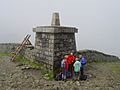
The Mourne Wall at the very top of Slieve Donard, where a trig point (a survey marker) stands on the summit tower.

