
Ballykelly, County Londonderry facts for kids
Quick facts for kids Ballykelly
|
|
|---|---|
 The village centre, located on the A2 |
|

Ballykelly
|
|
| Population | 2,107 (2011 Census) |
| District |
|
| County | |
| Country | Northern Ireland |
| Sovereign state | United Kingdom |
| Post town | LIMAVADY |
| Postcode district | BT49 |
| Dialling code | 028 |
| Police | Northern Ireland |
| Fire | Northern Ireland |
| Ambulance | Northern Ireland |
| EU Parliament | Northern Ireland |
| UK Parliament |
|

Ballykelly (which means "O'Kelly's Townland" in Irish) is a friendly village in County Londonderry, Northern Ireland. It's about 3 miles (5 km) west of Limavady on the main A2 road and 15 miles (24 km) east of Derry. In 2011, about 2,107 people lived here. Ballykelly is part of the Causeway Coast and Glens area.
Contents
- Discover Ballykelly's Unique Buildings
- Who Represents Ballykelly?
- Ballykelly's Past: A Look Back
- Fun Places to Visit in Ballykelly
- Who Lives in Ballykelly?
- Ballykelly's Weather
- Getting Around Ballykelly
- Sports in Ballykelly
- Schools in Ballykelly
- Churches and Faith in Ballykelly
- Famous People from Ballykelly
- Images for kids
- See also
Discover Ballykelly's Unique Buildings
Ballykelly has some really old and interesting buildings. Many of them were built by the London Company of Fishmongers. They helped develop the village in the 1700s and 1800s.
You can see the Tamlaghtfinlagan Parish Church, which was built by Earl Frederick Hervey. He was a bishop in the 1700s. Other important buildings include the Presbyterian Church, the Drummond Hotel, and the North West Independent Hospital. All these were also built by the Fishmongers Company.
The village offers great views across Lough Foyle to Inishowen in County Donegal. Ballykelly is also next to Ballykelly Forest, which was the first State Forest in Northern Ireland.
Who Represents Ballykelly?
Ballykelly is part of the East Londonderry area for the UK Parliament. The person who represents the village there is Gregory Campbell. He is a member of the Democratic Unionist Party (DUP).
Ballykelly's Past: A Look Back
How the Village Grew
Ballykelly was first planned as a "Plantation settlement." This means it was set up by English and Scottish settlers long ago. The village grew a lot when a World War II airfield was built nearby.
RAF Ballykelly and Shackleton Barracks
RAF Ballykelly was an airfield that opened in 1941. It was used by the RAF Coastal Command during World War II. It closed in 1971 because the British Government cut defence spending. The airfield then became a base for the British Army, called Shackleton Barracks. The Army left Shackleton Barracks in 2008.
During World War II, an RAF bomber plane crashed near Ballykelly. It was on a training flight when a parachute got caught in the plane's tail. This made the plane go out of control, and sadly, the crew lost their lives.
Ancient History and Monasteries
Christianity has been in this area since 585 AD! You can still see the remains of an old monastery called Tamlaght Finlagan Monastery. It's located on Tully Road. This ancient abbey was founded by St. Colmcille for St. Fionnlogha. Not much is known about why it fell into ruins, but it once had a round tower.
Fun Places to Visit in Ballykelly
- Ballykelly Forest: This forest is west of the village. It was once known as the Camman Wood. Long ago, it was a popular spot for highwaymen who would rob coaches traveling between Coleraine and Derry!
- Rough Fort: Between Limavady and Ballykelly, you'll find Rough Fort. It's one of the best-preserved ancient earthworks in the area. It covers about 1 acre (0.4 hectares).
- Sampson's Tower: This is a tall, fortified tower built to remember Arthur Sampson. He worked for the London Worshipful Company of Fishmongers for 40 years.
- Shackleton Barracks: This place became famous in 2006. A Ryanair plane accidentally landed there instead of at City of Derry Airport!
- Lough Shore Base Line Trigpoint: Behind the Kings Lane Estate, you can see the remains of this old tower. It was one of three towers used to help map Ireland accurately.
Who Lives in Ballykelly?
Ballykelly is called a "village" by the Northern Ireland Statistics and Research Agency. This means it has between 1,000 and 2,250 people. On March 27, 2011, there were 2,107 people living in Ballykelly.
- About 23% of the people were under 16 years old.
- About 10% were 65 years old or older.
- The population was almost equally split between males (50.17%) and females (49.83%).
- About 58% of people were from a Catholic background.
- About 38% were from a Protestant or other Christian background.
- Many people felt they had a British, Irish, or Northern Irish national identity.
Ballykelly's Weather
Ballykelly has an oceanic climate. This means it has mild summers and cool winters.
| Climate data for Ballykelly (Derry Airport 1991–2020) | |||||||||||||
|---|---|---|---|---|---|---|---|---|---|---|---|---|---|
| Month | Jan | Feb | Mar | Apr | May | Jun | Jul | Aug | Sep | Oct | Nov | Dec | Year |
| Mean daily maximum °C (°F) | 8.1 (46.6) |
8.6 (47.5) |
10.3 (50.5) |
12.5 (54.5) |
15.3 (59.5) |
17.4 (63.3) |
19.0 (66.2) |
18.7 (65.7) |
16.9 (62.4) |
13.6 (56.5) |
10.5 (50.9) |
8.3 (46.9) |
13.3 (55.9) |
| Mean daily minimum °C (°F) | 2.7 (36.9) |
2.5 (36.5) |
3.6 (38.5) |
5.1 (41.2) |
7.3 (45.1) |
9.9 (49.8) |
11.7 (53.1) |
11.6 (52.9) |
10.0 (50.0) |
7.3 (45.1) |
4.7 (40.5) |
2.8 (37.0) |
6.6 (43.9) |
| Average precipitation mm (inches) | 83.5 (3.29) |
70.1 (2.76) |
61.6 (2.43) |
54.0 (2.13) |
52.9 (2.08) |
59.6 (2.35) |
70.2 (2.76) |
76.4 (3.01) |
61.9 (2.44) |
83.4 (3.28) |
91.7 (3.61) |
95.7 (3.77) |
861 (33.91) |
| Average precipitation days (≥ 1 mm) | 17.0 | 14.5 | 14.5 | 12.0 | 12.7 | 12.5 | 14.0 | 14.3 | 13.7 | 15.5 | 17.7 | 17.3 | 175.7 |
| Average relative humidity (%) | 85 | 83 | 78 | 73 | 74 | 75 | 77 | 79 | 80 | 82 | 85 | 86 | 80 |
| Average dew point °C (°F) | 3 (37) |
4 (39) |
4 (39) |
6 (43) |
8 (46) |
11 (52) |
12 (54) |
12 (54) |
11 (52) |
9 (48) |
6 (43) |
4 (39) |
8 (46) |
| Mean monthly sunshine hours | 52.4 | 74.3 | 107.4 | 164.1 | 204.7 | 161.3 | 145.6 | 148.8 | 119.9 | 84.6 | 58.4 | 37.0 | 1,358.5 |
| Mean daily sunshine hours | 1.7 | 2.6 | 3.3 | 5.2 | 6.5 | 5.4 | 4.5 | 4.6 | 4.0 | 3.3 | 1.9 | 1.2 | 3.7 |
| Average ultraviolet index | 0 | 1 | 2 | 3 | 5 | 6 | 6 | 5 | 3 | 2 | 1 | 0 | 3 |
| Source 1: UK Met Office | |||||||||||||
| Source 2: Time and Date (humidity and dew points) Weather Atlas (UV index and daily sunshine hours) | |||||||||||||
Getting Around Ballykelly
- Ballykelly has good roads that connect it to Derry and Limavady.
- The City of Derry Airport is only about 9 km (5.6 mi) to the west.
- The Broharris Canal was built in the 1820s.
- Ballykelly used to have a railway station, which opened in 1852 but closed in 1954. There are no train links now, but the Derry to Belfast railway line runs nearby.
Sports in Ballykelly
- Gaelic football: This sport is played at Glack GAC. Players from Ballykelly and the Glack area join this club.
- Camogie: Ladies also play camogie at Glack GAC.
- Cricket: The Nedd CC is the local cricket team in Ballykelly. They play in the Senior League 2 of the North West Cricket Union.
Schools in Ballykelly
- Ballykelly Primary School
- St. Finlough's Primary School, Glack, Ballykelly
Churches and Faith in Ballykelly
Catholic Church
The current Catholic church is called St Finlough's and is on Loughermore Road. The history of Catholicism in the area goes back to 585 AD. You can still see the ruins of an old chapel and ancient abbey on Tully Road. This abbey was founded by St. Colmcille for St. Fionnlogha.
After a period when Catholic worship was difficult, a small chapel called "The Hollow" was built in 1796. This was allowed after a law changed, letting Catholics practice their religion more freely. The current St. Finlough's chapel was finished in 1849.
Anglican Church
The Anglican parish of Tamlaghtfinlagan was originally about 1 mile (1.6 km) southwest of the village. The name Tamlaghtfinlagan means "the resting place of Finliganus," who was one of St. Columba's monks. The old abbey building is still there, but it's in ruins. The current church building was finished in 1795. It's a simple church with three aisles and a small chancel. Much of it was built by the Worshipful Company of Fishmongers.
Presbyterian Church
The Presbyterian Church was built in 1827 by the Fishmongers Company from London. It is a very important historical building.

Famous People from Ballykelly
- Sally Brown, a Paralympic athlete, comes from Ballykelly.
Images for kids
-
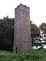
Sampson's Tower

See also
 In Spanish: Ballykelly para niños
