
Ballynahinch, County Down facts for kids
Quick facts for kids Ballynahinch
|
|
|---|---|
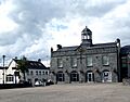
 Ballynahinch Market House (middle) and Credit Union (left) |
|

|
|
| Population | 6,164 (2021 census) |
| District |
|
| County | |
| Country | Northern Ireland |
| Sovereign state | United Kingdom |
| Post town | BALLYNAHINCH |
| Postcode district | BT24 |
| Dialling code | 028 |
| Police | Northern Ireland |
| Fire | Northern Ireland |
| Ambulance | Northern Ireland |
| EU Parliament | Northern Ireland |
| UK Parliament |
|
| NI Assembly |
|
Ballynahinch (which means "settlement of the island/water-meadow" in Irish) is a town in County Down, Northern Ireland. In the 2021 census, 6,164 people lived there.
Ballynahinch has always been a market town. Even today, a market is held in the town square every Thursday. The town is located on the main A24 road. This road connects Belfast to Clough, which is near Newcastle. Ballynahinch has a leisure centre and other useful places. Recently, a special group was set up to help improve the town and nearby areas like Spa and Drumaness.
Contents
History

Before the 1600s, the McCartan family controlled the land around Ballynahinch. During a time of wars in the 1600s, a Catholic officer named Patrick McCartan captured a castle in Downpatrick. Later, he was captured and executed in 1653. His lands were taken by the government and sold to Sir George Rawdon.
Sir George Rawdon built two flour mills and started the town of Ballynahinch. He created a special market square. In 1683, King Charles II gave Ballynahinch a special permission. This allowed the town to hold its market every Thursday. It also allowed two big fairs each year, on February 1st and June 29th.
More people moved to Ballynahinch from Scotland, and the town grew. It became a busy market town where people sold animals, corn, potatoes, and especially flax. Flax was used to make linen. Sir John Rawdon, a relative of Sir George, lived in Montalto House in Ballynahinch. He helped the town a lot. He supported the linen market and built the Ballynahinch Market House. By the late 1700s, the market was doing very well, making about £300 each week.
In 1798, a group called the Society of United Irishmen started a rebellion. This group wanted Ireland to be an independent country. The rebellion spread to Ulster. The Battle of Ballynahinch happened on June 12, 1798. About 4,000 United Irishmen were in Ballynahinch when government forces attacked them. The government troops used cannons all day until the United Irishmen had to leave. After the battle, the winning troops burned many houses in Ballynahinch. The leader of the United Irishmen, Henry Munro, was captured and executed soon after.
In 1802, Montalto and Ballynahinch were sold to David Ker. He saw that many wealthy tourists liked to visit "medicinal spa wells." So, he developed the spa wells just outside the town. The town continued to grow after this. In the 1920s, the police station in Ballynahinch was attacked. Later, in 1996, the British Prime Minister John Major visited Ballynahinch. Today, Ballynahinch is home to the Montalto Estate, Montalto House, and The Carriage Rooms. The Carriage Rooms were even used as a filming location for Disney's TV show, The Lodge.
Demography
Ballynahinch is known as a Small Town by the NI Statistics and Research Agency (NISRA). This means it has between 4,500 and 10,000 people.
2021 census
On March 21, 2021, a census was taken. Here's what it showed about Ballynahinch:
- There were 6,164 people living in the town.
- About 53% of people were brought up as Protestants, and about 34% were brought up as Catholics.
- Many people felt they had a British national identity (57%). Others felt they had a Northern Irish identity (36%), or an Irish identity (17%). Some people felt they had more than one identity.
- About 20% of the people were under 16 years old. About 18% were 65 years or older.
- The average age of people in Ballynahinch was 39 years.
- About 11% of people knew some Ulster-Scots, and about 5% knew some Irish (Gaelic).
- About 1.5% of people aged 16-74 were unemployed.
Buildings of note
- The town's market house was built in 1795. It is now used as a community centre.
- There are old flax and corn mills on the edge of town. There are plans to develop these sites.
- Ballynahinch Orange Hall is another important building.
Transport
Traffic congestion
Ballynahinch is known for its heavy traffic. A new road, called a bypass, has been planned to go around the town. This would help reduce traffic. Experts studied the land for the bypass over twenty years ago. However, money has not yet been given to build it. In the 1990s, different ways to control traffic were tried. This included the one-way system used today. But these plans have not fully solved the problem of so many cars passing through the town every day.
In January 2012, the Minister for Regional Development made an announcement. They said that a plan for the A24 Ballynahinch bypass was approved. This new road would go around the eastern side of the town. It would be about 3.1 kilometers long. The road would need a lot of earthworks because of the hills and the Ballynahinch River flood plain. Three large structures would be built where the road crosses Moss Road, Crossgar Road, and the Ballynahinch River. There would also be a junction with the B7 Crossgar Road. This shows that the planning is very advanced. However, the official plan is for construction to happen between 2014 and 2019.
Rail
- Ballynahinch railway station and Ballynahinch Junction railway station were part of the Belfast and County Down Railway. Both stations opened on September 10, 1858. They both closed on January 16, 1950.
Education
- The South Eastern Regional College has a main campus building in Ballynahinch.
- Assumption Grammar School
- The High School Ballynahinch
- St Colman's High and Sixth Form College
- Drumlins Integrated Primary School
- Ballynahinch Primary School
- Saint Patrick's Primary School
- Spa Primary School
Churches
- First Presbyterian Church, on Windmill Street, has a long history. Presbyterians have been in the town since the 1630s. The church building was built in 1751. It is still the largest and oldest church building in Ballynahinch.
- Edengrove Presbyterian Church, on Dromore Road. The first church building here was built in 1774. The current church was built in 1841.
- St Patrick's Roman Catholic Church, at 24 Church Street. The main church was finished in 1812. The tower and other parts were added in the 1860s.
- Ballynahinch Free Presbyterian Church was started in 1978.
Notable people
- William Reddick (1812–1885), an American politician, was born in Ballynahinch.
- Hugh Gourley (1825–1906) moved from Ballynahinch when he was 27. He was elected Mayor of Dunedin, New Zealand, two times.
- John McMullen (1832–1883), born in Ballynahinch, became a Roman Catholic Bishop in Iowa, United States.
- Frank Thompson (1885–1950), an Irish international footballer and manager, was born in Ballynahinch.
- Joseph Coskery (1895–1965), an Irish international cricketer, was from Ballynahinch.
- David Howland, a professional footballer, was born in Ballynahinch in 1986.
Sport
- Ballynahinch Rugby Football Club was founded in 1954. Their home ground is Ballymacarn Park. They play in AIL Division One.
- Ballynahinch United F.C. plays in the Northern Amateur Football League. They play at Millbridge, just outside the town.
- Ballynahinch Olympic FC was founded in 1973. They have senior teams in the Northern Amateur Football League and the Newcastle League. They also have junior teams.
- Temple Rangers Football Club has two teams in the Northern Amateur Football League. They play their home games at the pitches in the Langley Road estate.
- Ballynahinch Rabbitohs rugby league football club are Ulster Rugby league champions. They won three titles in a row from 2009 to 2011. They also have a second team.
- Ballynahinch Hockey club has four teams (two men's and two women's). They play in the Ulster hockey leagues.
Images for kids
-
Ballynahinch Market House (middle) and Credit Union (left)
See also
 In Spanish: Ballynahinch para niños
