Carryduff facts for kids
Quick facts for kids Carryduff
|
|
|---|---|
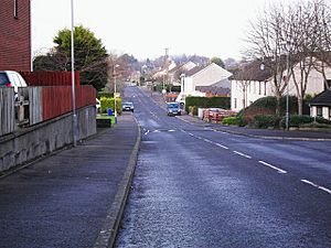
 Killynure Road passes through Carryduff |
|
| Population | 7,173 (2021 census) |
| Irish grid reference | J3683065382 |
| District |
|
| County | |
| Country | Northern Ireland |
| Sovereign state | United Kingdom |
| Post town | BELFAST |
| Postcode district | BT8 |
| Dialling code | 028 |
| Police | Northern Ireland |
| Fire | Northern Ireland |
| Ambulance | Northern Ireland |
| EU Parliament | Northern Ireland |
| UK Parliament |
|
| NI Assembly |
|
Carryduff (which means "Black Hugh's quarter" in Irish) is a small town and townland (a small area of land) in County Down, Northern Ireland. It's about 10 kilometers (6 miles) south of Belfast city centre. In 2021, 7,173 people lived there.
Most of Carryduff is within its own townland. But some parts of the town also stretch into the nearby townlands of Killynure and Mealough.
Contents
History of Carryduff
One of the first times Carryduff was mentioned was in 1622. Its name was written as Carrow-Hugh-Duffe. The original village grew where six roads and a river met. This spot is also home to the ancient Queen's Fort Rath, which is an old circular fort.
The main road from Belfast (the A24) goes through a gap in the Castlereagh Hills. It then splits in Carryduff. One road (the A7) goes towards Downpatrick. The other (A24) continues to Newcastle. Another road (the B178) from Newtownards and Comber also crosses here. All these roads cross the small Carryduff River. This river flows north and eventually joins the River Lagan.
Water Supply for Belfast
The Knockbracken Reservoir was built for the Belfast Water Commissioners. It opened in 1901. In the same year, the Mourne Conduit was built. This carried water from rivers in Kilkeel and Annalong to Carryduff. From there, the water went on to Belfast. A newer pipeline, called the Aquarius pipeline, replaced the Mourne Conduit between 1999 and 2004.
Growing as a Town
Because Carryduff is close to Belfast and has good road links, it started to grow in the 1960s. Many new houses were built. The "Town and Country Shopping Centre" and Carryduff Primary School were also built then. In the 1970s, the Killynure housing estate was added.
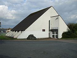
Development continued in the 1980s. Carryduff became a "commuter town." This means many people living there traveled to Belfast for work. More building happened in the 1990s, including Carryduff Library and Carryduff Shopping Centre. During this time, the Carryduff River was put into a culvert (an underground pipe) for much of its path through the town.
Today, there isn't much open land left between Carryduff and Belfast. In 2018, the old Knockbracken reservoir was turned into Ireland's largest aqua park. It offers many fun water activities.
People of Carryduff (Demography)
Demography is the study of populations. It looks at things like how many people live somewhere, their ages, and backgrounds.
2021 Census Information
On March 21, 2021, the population of Carryduff was 7,173 people. Here's what the census found:
- About 53.36% of people were from a Catholic background.
- About 36.46% were from a Protestant or other Christian background.
- About 1.4% were from other religious backgrounds.
- About 8.77% had no religious background.
- When asked about their national identity, 37.22% said British.
- 39.89% said Irish.
- 35.69% said Northern Irish.
- People could choose more than one national identity.
2011 Census Information
On March 27, 2011, Carryduff had 6,961 people.
- About 21.45% were under 16 years old.
- About 13.92% were 65 years or older.
- The average age was 38 years.
- About 47.55% of the people were male, and 52.45% were female.
- Most people (96.83%) were from the white ethnic group.
- About 49.85% were from a Catholic background.
- About 42.24% were from a Protestant or other Christian background.
- When asked about their national identity, 49.39% said British.
- 28.96% said Irish.
- 32.45% said Northern Irish.
- People could choose more than one national identity.
Sports in Carryduff
Gaelic Games
The local Gaelic Athletic Association (GAA) club is Carryduff GAC. It started in 1971 when parents wanted more playing facilities for their children. They formed a schoolboys Gaelic football team. Soon after, a full GAA club was created. Carryduff has had several players who played for the county team. These include Greg Blaney, Neil Collins, Mark McCartan, and John Kelly. They were part of the Down county football team that won the All-Ireland championships in the 1990s.
Running
Carryduff Running Club was started in 2022. It is connected with Athletics NI, which supports athletics in Northern Ireland. The club offers a free "Couch to 5k" program for non-members. This program helps people go from not running to being able to run 5 kilometers. They also have weekly organized runs.
Football (Soccer)
Carryduff has two local men's football teams: Carryduff Colts F.C. and Carryduff Athletic F.C. Both teams play at the Lough Moss pitches in the town.
Churches
The Catholic parish of Drumbo was set up in late 1943. This happened after Mr Patrick Mallon offered land for a church. After the Belfast Blitz (bombing during World War II), many families from Belfast moved to the area. Also, US troops arrived, which increased the Catholic population.
On June 30, 1946, a new church called the Immaculate Heart of Mary was opened. Nine years later, on January 9, 1955, St Joseph's Primary School opened next to the church.
See also
 In Spanish: Carryduff para niños
 | Chris Smalls |
 | Fred Hampton |
 | Ralph Abernathy |


