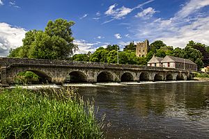
County Tipperary facts for kids
Quick facts for kids
County Tipperary
Contae Thiobraid Árann
|
||
|---|---|---|
|
||
| Nickname(s):
The Premier County
|
||
 |
||
| Country | Ireland | |
| Province | Munster | |
| Region | Southern | |
| Shired | 1328 | |
| Divided | 1838 | |
| Reunified | 2014 | |
| County towns | Nenagh/Clonmel | |
| Area | ||
| • Total | 4,305 km2 (1,662 sq mi) | |
| Area rank | 6th | |
| Highest elevation | 918 m (3,012 ft) | |
| Population
(2022)
|
||
| • Total | 167,895 | |
| • Rank | 12th | |
| • Density | 39.000/km2 (101.010/sq mi) | |
| Time zone | UTC±0 (WET) | |
| • Summer (DST) | UTC+1 (IST) | |
| Eircode routing keys |
E21, E25, E32, E34, E41, E45, E53, E91 (primarily)
|
|
| Telephone area codes | 051, 0504, 0505, 052, 061, 062, 067 (primarily) | |
| Vehicle index mark code |
T | |
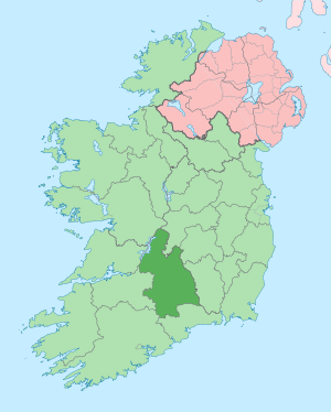
County Tipperary (Irish: Contae Thiobraid Árann) is a county in Ireland. It is located in the province of Munster, which is in the southern part of the country. The county is named after the town of Tipperary. It was first set up in the early 1200s, not long after the Normans arrived in Ireland.
Tipperary is Ireland's largest county that does not touch the sea. It shares its borders with eight other counties. This is more than any other county in Ireland! In 2022, about 167,895 people lived here. The biggest towns are Clonmel, Nenagh, and Thurles.
Tipperary County Council is the local government for the county. For a long time, from 1899 to 2014, County Tipperary was split into two parts: North Tipperary and South Tipperary. Each part had its own local council. But in 2014, they joined back together to form one county again.
Contents
Exploring Tipperary's Geography
Tipperary is the sixth largest of Ireland's 32 counties by size. It is the 12th largest when you look at its population. Among the six counties in Munster, it is the third largest in both size and population. It is also the biggest county in Ireland that is completely surrounded by land.
Tipperary is bordered by many counties. These include Offaly, Laois, Kilkenny, Waterford, Cork, Limerick, Clare, and Galway. Having eight neighbours is the most for any county in Ireland!
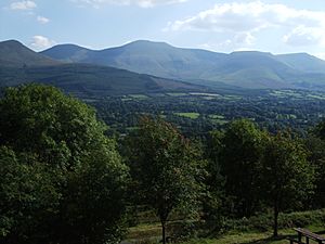
Most of Tipperary is part of Ireland's central plain. However, it also has several mountain ranges. These include the Knockmealdown, Galtee, Arra Hills, and Silvermine Mountains. The River Suir drains most of the county. Other rivers like the River Shannon and River Nore also flow through parts of it. The county does not have any coastline.
The central part of Tipperary is called 'the Golden Vale'. This is a very fertile area with rich farmland. It stretches into counties Limerick and Cork. The highest point in Tipperary is Galtymore mountain, which is 917 meters tall. The River Shannon forms part of the county's northwest border. The River Suir starts at a place called the Devil's Bit and flows all the way to the sea at Waterford.
Historic Divisions: Baronies
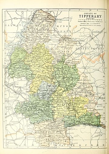
County Tipperary has 12 historic areas called baronies. These include Clanwilliam, Eliogarty, Iffa and Offa East, Iffa and Offa West, Ikerrin, Kilnamanagh Lower, Kilnamanagh Upper, Middle Third, Ormond Lower, Ormond Upper, Owney and Arra, and Slievardagh. These were old ways to divide the land.
Smallest Areas: Townlands
The smallest official land divisions in Ireland are called townlands. County Tipperary has 3,159 of these tiny areas.
Tipperary's Main Towns
Here are the largest towns in County Tipperary based on the 2016 census:
| Rank | Town | Population (2016 census) |
|---|---|---|
| 1 | Clonmel | 17,140 |
| 2 | Nenagh | 8,968 |
| 3 | Thurles | 7,940 |
| 4 | Carrick-on-Suir | 5,771 |
| 5 | Roscrea | 5,446 |
| 6 | Tipperary | 4,979 |
| 7 | Cashel | 4,422 |
| 8 | Cahir | 3,593 |
| 9 | Ballina | 2,632 |
| 10 | Templemore | 1,939 |
| 11 | Fethard | 1,545 |
A Look at Tipperary's History
After the Normans invaded Ireland, the area of Munster became a lordship. By 1210, it was divided into two shires: Tipperary and Limerick. In 1328, Tipperary was given to the Earls of Ormond. This made it a special area called a "county palatine," where the Earls had a lot of power.
For a long time, the county town of Clonmel was where important legal meetings were held. But it was far for people living in the north of the county. So, in 1838, Tipperary was split into two "ridings": North Tipperary and South Tipperary. Each riding had its own local government. This continued until 2014, when the two parts were joined back together to form one County Tipperary again.
Tipperary's Culture and Identity
Tipperary is often called the "Premier County." This nickname was given by Thomas Davis in the 1840s. He was the editor of The Nation newspaper. He said it was a tribute to the strong national pride in Tipperary. He famously wrote, "where Tipperary leads, Ireland follows."
Tipperary is also famous for the song "It's a Long Way to Tipperary." This song was written by Jack Judge, whose grandparents were from the county. It became very popular with British soldiers during World War I. Another important song for the county is "Slievenamon." This song was written by Charles Kickham and is often sung at sports events involving Tipperary teams.
Irish Language in Tipperary
County Tipperary does not have a Gaeltacht area. Gaeltachts are places where Irish is the main language spoken every day. Because of this, there are not many Irish speakers in Tipperary. However, there are five Gaelscoileanna (Irish language primary schools) and two Gaelcholáistí (Irish language secondary schools). These schools teach all subjects through Irish.
Tipperary's Economy
The area around Clonmel is a key economic center for the county. Big companies like Bulmers (who make drinks) and Merck & Co. (a pharmaceutical company) have factories there.
Tipperary has a lot of rich farmland, especially in the Golden Vale area. This makes it one of the best farming regions in Ireland. The county is also well-known for its horse breeding industry. Coolmore Stud, the biggest thoroughbred horse breeding farm in the world, is located here.
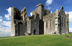
Tourism is also very important for County Tipperary. Many people visit places like Lough Derg, Thurles, the Rock of Cashel, Ormonde Castle, Cahir Castle, and Tipperary Crystal.
Getting Around Tipperary: Transport
Most people in County Tipperary travel by road. The M7 motorway goes through the north of the county, passing through Roscrea and Nenagh. The M8 motorway cuts through the middle of the county. Both of these are very busy roads. The N24 road crosses the southern part of Tipperary. It goes through Tipperary Town, Bansha, and around Clonmel and Carrick-on-Suir.
Railways in Tipperary
Tipperary also has several train stations. These stations are on lines that connect places in Tipperary to major cities like Cork, Dublin Heuston, Waterford, Limerick, and Galway. There are also plans to reopen the train line between Clonmel and Thurles in the future.
Sports in County Tipperary
County Tipperary has a very strong connection to the Gaelic Athletic Association (GAA). The GAA was actually founded in Thurles in 1884! Tipperary GAA organizes local games for sports like hurling, Gaelic football, camogie, and handball. They also have county teams that compete in national championships.
Tipperary is the only county that has won an All-Ireland title in a Gaelic game in every decade since the 1880s. Hurling is the most popular sport in the county. The Tipperary county hurling team has won 28 All-Ireland titles. This is the third-highest number of titles for any county hurling team. The Tipperary county football team has won four All-Ireland titles.
Horse racing is also popular in Tipperary. There are racecourses at Tipperary Racecourse, Thurles Racecourse, and Clonmel Racecourse.
Cool Places to Visit in Tipperary
- Ardfinnan Castle
- Athassel Priory
- Cahir Castle
- Coolmore Stud – a famous horse breeding farm
- Devil's Bit – a mountain near Templemore
- Dromineer
- Galtymore – the highest mountain in County Tipperary (919m)
- Glen of Aherlow
- Glengarra Wood
- Holy Cross Abbey
- Kilcash Castle
- Lorrha
- Lough Derg – a large lake
- Monaincha
- Mount St. Joseph Abbey, Roscrea
- Mitchelstown Cave
- Nenagh Castle
- Ormonde Castle, Carrick-on-Suir
- Redwood Castle (Castle Egan)
- Rock of Cashel – a historic site with ancient buildings
- Roscrea Castle
- Semple Stadium – a famous GAA stadium
- Slievenamon – a mountain linked to many Irish legends (721m)
- Timoney Standing Stones – ancient stone monuments
Famous People from County Tipperary
Many notable people come from County Tipperary, including:
- Anne Anderson, a diplomat who was an ambassador to the United States.
- The Clancy Brothers, a famous folk music group.
- Patrick Collison and John Collison, who co-founded the company Stripe.
- Kerry Condon, an actress.
- Una Healy, a singer and member of the girl group The Saturdays.
- Alan Kelly, a politician.
- Tom Kiely, an Olympic gold medalist.
- Shane Long, a footballer.
- Shane MacGowan, a musician and songwriter from the band The Pogues.
- Frank Patterson, a famous tenor singer.
- Rachael Blackmore, a top National Hunt Jockey.
- Tony Ryan, who founded Ryanair.
See also
 In Spanish: Condado de Tipperary para niños
 | Anna J. Cooper |
 | Mary McLeod Bethune |
 | Lillie Mae Bradford |


