Galtymore facts for kids
Quick facts for kids Galtymore(and Galty Mountains) |
|
|---|---|
| Cnoc Mór na nGaibhlte | |
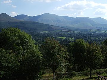
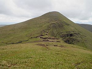
Galtee Mountain range seen from the north, with the summit of Galteemore at its centre
|
|
| Highest point | |
| Elevation | 917.9 m (3,011 ft) |
| Prominence | 898 m (2,946 ft) |
| Listing | County top (Limerick and Tipperary), P600, Marilyn, Furth, Hewitt, Arderin, Simm, Vandeleur-Lynam |
| Naming | |
| English translation | big hill of the Galtees |
| Language of name | Irish |
| Geography | |
| Location | County Limerick/Tipperary, Republic of Ireland |
| Parent range | Galty Mountains |
| OSI/OSNI grid | R878237 |
| Topo map | OSi Discovery 74 |
| Geology | |
| Age of rock | Devonian |
| Mountain type | Conglomerate & purple-reddish sandstone, (Slievenamuck Conglomerate Formation) |
| Climbing | |
| Easiest route | Black Road Route |
Galtymore or Galteemore is a famous mountain in Munster, Ireland. Its name in Irish is Cnoc Mór na nGaibhlte, which means "big hill of the Galtees". Standing at 917.9 meters (3,011 feet) tall, it is one of Ireland's highest mountains. Galtymore is the 12th-highest on the Arderin list and 14th-highest on the Vandeleur-Lynam list.
This mountain is very important because it has the 4th-highest topographic prominence in Ireland. This means it stands out a lot from the land around it. Because of this, Galtymore is called a "P600" or "major mountain". It is also one of the 13 "Irish Munros", which are tall mountains outside of Scotland.
Galtymore is the highest peak in the Galty Mountains, also known as the Galtee Mountains. This mountain range is made of sandstone and shale. It stretches for about 30 kilometers (19 miles) from east to west. The range has 24 peaks that are over 100 meters (328 feet) high. Galtymore is the highest point in both Tipperary and Limerick.
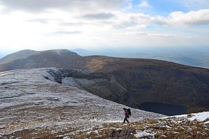
Many people enjoy hiking Galtymore. The easiest way to reach the top is the 3–4 hour Black Road Route. More adventurous hikers can try the 5–6 hour Circuit of Glencushnabinnia. There is also a very long hike called the Galtee Crossing. This takes at least 10 hours and covers the entire mountain range. An event called the Galtee Challenge happens every year on this route.
The mountain and its deep, round lakes (called corrie lakes) are part of many old Irish stories. These tales often involve Saint Patrick and mythical serpents.
Contents
What's in a Name?
The name "Galtymore" comes from the Irish Cnoc Mór na nGaibhlte, meaning "big hill of the Galtees". This name was written down as early as 1654. The peak is also called "Galtymore Mountain" on official maps. A nearby village on its southern side is named Knocknagalty, which means "hill of the Galtees".
Some people think the name "Galty" comes from Sléibhte na gCoillte. This Irish phrase means "mountains of the forests". Another old Irish name for the range was Sliabh gCrot, meaning "the hump mountains".
The very top of Galtymore is known as Dawson's Table. This name comes from the Dawson-Massey family. They owned a lot of land in the area a long time ago. The popular "Galtee" bacon brand also got its name from these mountains.
Mountain Rocks and Shapes
The Galty Mountains are mostly made of Old Red Sandstone. This type of rock formed during the Devonian period. It has a purple-red color and does not contain fossils. The mountains also have Silurian shales.
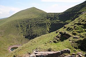
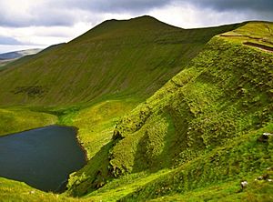
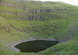
The southern slopes of the Galty range are smooth. But the northern side is very steep. It has deep, bowl-shaped hollows called corries. Many of these corries now hold lakes. The long ridge in the middle of the Galtys was too high for ancient ice sheets to cover. This led to small glaciers forming in the corries. The mountain tops are covered by large rock formations called tors. These tors are made of a rock called conglomerate.
Exploring the Galty Mountains
The Galty Mountains are a long, mostly straight range. They stretch for about 30 kilometers (19 miles) from east to west. The central part of the range is about 15 kilometers (9 miles) long. This section includes the highest peaks. These are Galtymore (918 m), Lyracappul (825 m), Carrignabinnia (823 m), and Slievecushnabinnia (775 m).
Many peaks in the central part have a good prominence. This means the ridge stays high for a long distance. This makes it a great place for hikers. The Galty range has 24 peaks over 100 meters (328 feet) high. Thirteen of these are over 2,000 feet (610 m). Five peaks are classified as Marilyns. This means they have a prominence of over 150 meters (492 feet). The Galtys are known as Ireland's highest "inland" mountain range.
Galtymore and Galtybeg are in the middle of the range. Their north faces show signs of ancient glaciers. There are several deep corries, and most of them now have lakes. Lough Diheen is between Galtymore and Galtybeg. Lough Curra is between Galtymore and Slievecushnabinnia.
Galtymore is the 460th-highest mountain in Britain and Ireland. It is also the 12th most prominent. The Scottish Mountaineering Club (SMC) calls Galtymore one of 34 "Furths". These are mountains over 3,000 feet (914 m) that meet certain criteria and are outside Scotland. Galtymore is also a "P600" mountain. This means it is a "major" mountain in Britain and Ireland.
Hiking Adventures
The easiest way to hike to the top of Galtymore is the Black Road Route. This route is about 9 kilometers (5.6 miles) long and takes 3–4 hours. It starts at the Black Road car park near Skeheenarinky village. You will first reach the top of Galtybeg (799 m) before Galtymore. Then, you follow the same path back down.
For a more challenging hike, try the Circuit of Glencushnabinnia. This 12-kilometer (7.5 miles) loop takes 5–6 hours. It goes around Galtymore's deep northern corries, where Lough Curra and Lough Dihneen are located. The hike starts near the Clydagh Bridge. You will climb Cush (641 m), Galtybeg (779 m), Galtymore, and Slievecushnabinnia (775 m). Then you return to the start.
The Galtee Challenge is an annual event organized by the Galtee Walking Club. It is a full 31-kilometer (19 miles) crossing of the entire range from east to west. This hike, also called the Galtee Crossing, takes over 10 hours. It includes all the main peaks of the Galty Mountains. The challenge usually starts in Cahir and finishes in Anglesboro Village. Even though it's a long distance, the changes in height are not too extreme, making the 10-hour estimate reasonable.
Peaks of the Galty Mountains
The MountainViews Online Database lists 24 peaks in the Galty Mountains that are over 100 meters (328 feet) high.
Furth (or Irish Munro): Height over 3,000 feet, and on the SMC Furth list. Marilyn: Any height, and prominence over 150 meters.
| Height rank |
Prom. rank |
Name | Irish name (if different) | Translation | Height (m) |
Prom. (m) |
Height (ft) |
Prom. (ft) |
Topo. map |
OSI Grid Reference |
|---|---|---|---|---|---|---|---|---|---|---|
| 1 | 1 | Galtymore | Cnoc Mór na nGaibhlte | big hill of the Galtys | 918 | 898 | 3,011 | 2,946 | 74 | R878238 |
| 2 | 6 | Lyracappul | Ladhar an Chapaill | fork/confluence of the horse | 825 | 100 | 2,708 | 328 | 74 | R845232 |
| 3 | 22 | Carrignabinnia | Carraig na Binne | rock of the peak | 823 | 27 | 2,700 | 88 | 74 | R850237 |
| 4 | 5 | Greenane | An Grianán | sunny spot | 801 | 157 | 2,629 | 515 | 74 | R925239 |
| 5 | 9 | Galtybeg | — | — | 799 | 80 | 2,622 | 263 | 74 | R890241 |
| 6 | 16 | Greenane West | — | — | 787 | 39 | 2,582 | 129 | 74 | R910239 |
| 7 | 3 | Temple Hill | Cnoc an Teampaill | hill of the church | 783 | 188 | 2,569 | 617 | 74 | R833218 |
| 8 | 20 | Slievecushnabinnia | Sliabh Chois na Binne | mountain beside the peak | 775 | 28 | 2,542 | 92 | 74 | R858240 |
| 9 | 13 | Knockaterriff | Cnoc an Tairbh | hill of the bull | 692 | 51 | 2,269 | 168 | 74 | R848216 |
| 10 | 21 | Knockaterriff Beg | Cnoc an Tairbh Beag | hill of the little bull | 679 | 28 | 2,229 | 91 | 74 | R844222 |
| 11 | 4 | Cush | Cois | side/flank | 641 | 176 | 2,104 | 578 | 74 | R894262 |
| 12 | 7 | Monabrack | Móin Bhreac | speckled moor | 630 | 94 | 2,067 | 308 | 74 | R859219 |
| 13 | 18 | Laghtshanaquilla | Leacht Sheanchoille | burial monument of the old wood | 629 | 36 | 2,065 | 118 | 74 | R951250 |
| 14 | 11 | Knockeenatoung | Cnoicín na Teanga | hill of the tongue | 601 | 66 | 1,973 | 218 | 74 | R895219 |
| 15 | 23 | Lough Curra Mtn | — | — | 600 | 23 | 1,970 | 75 | 74 | R869242 |
| 16 | 24 | Laghtshanaquilla North-East Top | — | — | 598 | 19 | 1,962 | 62 | 74 | R957256 |
| 17 | 10 | Knockastakeen | Cnoc an Stáicín | hill of the little stack | 583 | 78 | 1,913 | 256 | 74 | R915258 |
| 18 | 14 | Sturrakeen | An Starraicín | "the pointed peak" or "the steeple" | 542 | 46 | 1,777 | 151 | 74 | R973253 |
| 19 | 8 | Benard | An Bhinn Ard | the high peak | 480 | 85 | 1,573 | 277 | 74 | R821199 |
| 20 | 12 | Slieveanard NE Top | — | — | 449 | 64 | 1,471 | 210 | 74 | S005264 |
| 21 | 15 | Seefin | Suí Finn | Fionn's seat | 447 | 42 | 1,465 | 136 | 74 | R891197 |
| 22 | 17 | Seefin N Top | — | — | 444 | 39 | 1,457 | 128 | 74 | R888206 |
| 23 | 19 | Slieveanard | Sliabh an Aird | mountain of the height | 438 | 33 | 1,436 | 108 | 74 | R992258 |
| 24 | 2 | Slievenamuck | Sliabh Muice | mountain of the pig | 369 | 234 | 1,211 | 768 | 66 | R842306 |
The Summit of Galtymore
The top of Galtymore is a large, bowl-shaped area with two peaks. This flat area is called Dawson's Table. It is named after the Dawson-Massey family, who owned land here long ago. There is a pile of stones, called a cairn, on top of each peak. The eastern cairn marks the true highest point of Galtymore. These two peaks give Galtymore a unique shape when seen from far away. The summit also marks the border between County Limerick and County Tipperary.
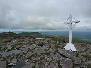
In 1975, a 7-foot (2.1 m) tall white iron cross was put on the north edge of Dawson's Table. A local man named Ted Kavanagh placed it there. The cross is a few meters from the eastern summit cairn. It faces the beautiful Glen of Aherlow. People paint it white every year to keep it looking good.
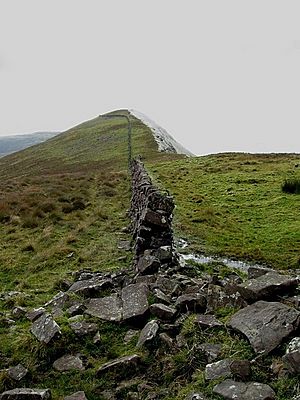
To the west of Galtymore's summit is a 3.5-kilometer (2.2 miles) long stone wall. It is known as the Galtee Wall. This wall was built in 1878 to separate two large estates. It took 30–40 men more than four years to build. The wall was built to give jobs to local farmers during a time when money was scarce. This is why it is sometimes called a "famine wall". The Galtee Wall stretches from Galtymore's west summit to the top of Lyracappul. Lyracappul is the second-highest peak in the Galtees.
Old Stories and Legends
The Galty Mountains appear in many old Irish folk tales. People believed that the deep corrie lakes in the Galtys were magical. In ancient Irish writings, the mountains were called Crotta Cliach. This name was linked to a legendary harp player named Cliach. The story says Cliach played his harps in the mountains to win over a magical woman. When he failed, he played two harps together. The hill then burst open and formed a lake. This lake is Lough Muskry.
Lough Muskry was also known as Loch Béal Dracon, or "lake of the dragon's mouth". An old tale from around 1000 AD tells of a dragon living in the lake. Another story says Saint Fursey drowned the dragon in the lake. There is also a famous folk tale about Saint Patrick and a serpent. The serpent was harming farm animals on the Galty Mountains. Saint Patrick banished it and chained it under Lake Muskry. He promised to release it on the Day of Judgement. But the serpent misunderstood and thought it meant Monday. So, every Easter Monday, the serpent comes up and asks Saint Patrick if it's Monday morning yet. Saint Patrick says "No," and the serpent goes back down for another year. A similar legend is told about Lough Dihneen, another lake in the Galtys.
Some people believe that Saint Patrick banishing the serpent made the land good for farming. Lake Muskry is also mentioned in the Irish mythological tale of the Caer Ibormeith.
1976 Air Crash
On September 20, 1976, three airmen died when their plane crashed on the Galtys. Their names were Tom Gannon, Jimmy Byrne, and Dick O'Reilly. They were from Abbeyshrule. The crash happened near a rock formation called O'Loughlin's Castle. These three men were founders of the Abbeyshrule Air Club.
A stone monument shaped like a plane's tailfin was put up to remember them. It is located a short distance into the Black Road Route. This sad event led to the creation of the South Eastern Mountain Rescue Association (SEMRA) in 1977. SEMRA remembered the crash on its 40th anniversary in September 2016.
See also
 In Spanish: Cnoc Mór na nGaibhlte para niños
 | Jewel Prestage |
 | Ella Baker |
 | Fannie Lou Hamer |


