Lee County, North Carolina facts for kids
Quick facts for kids
Lee County
|
|||
|---|---|---|---|

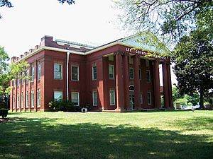
Lee County Courthouse
|
|||
|
|||
| Motto(s):
"Committed Today for a Better Tomorrow"
|
|||

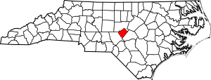
Location within the U.S. state of North Carolina
|
|||
 North Carolina's location within the U.S. |
|||
| Country | |||
| State | |||
| Founded | April 1, 1908 | ||
| Named for | Robert E. Lee | ||
| Seat | Sanford | ||
| Largest community | Sanford | ||
| Area | |||
| • Total | 259.20 sq mi (671.3 km2) | ||
| • Land | 255.06 sq mi (660.6 km2) | ||
| • Water | 4.14 sq mi (10.7 km2) 1.60% | ||
| Population
(2020)
|
|||
| • Total | 63,285 | ||
| • Estimate
(2023)
|
67,059 | ||
| • Density | 281.2/sq mi (108.6/km2) | ||
| Time zone | UTC−5 (Eastern) | ||
| • Summer (DST) | UTC−4 (EDT) | ||
| Congressional district | 9th | ||
Lee County is a county in the state of North Carolina. In 2020, about 63,285 people lived here. The main town and county seat is Sanford.
Lee County is part of the Sanford, NC Micropolitan Statistical Area. This area is also part of a larger region called the Combined Statistical Area. This bigger area includes Raleigh, Durham, and Cary. In 2023, about 2.3 million people lived in this larger area.
Contents
History of Lee County
Early Settlements and Growth
We don't know much about the early Native Americans who lived in the area that is now Lee County. People from Europe and Africa started settling here in the 1740s and 1750s.
In the 1850s, North Carolina's first commercial coal mine opened in a place called Egypt. During the American Civil War, this area provided coal and iron for the Confederate States of America.
How Lee County Was Formed
In 1907, people living in Sanford, which was then part of Moore County, wanted a new county. Traveling to Moore County's main town, Carthage, was difficult.
The North Carolina General Assembly (the state's law-making group) passed a law to create Lee County. This new county would be made from parts of Moore and Chatham counties. The law was set to start on April 1, 1908.
But first, the people living in the proposed new county had to vote on it. This vote, called a plebiscite, happened on July 1. Voters approved the new county with 875 votes for and 40 against.
County officials started their jobs on February 17, 1908. The county courthouse was built between Sanford and Jonesboro. County officers moved into the new courthouse in early March 1909.
Modern Development
After Lee County was created, its population and economy grew steadily. This growth was helped by successful industries like tobacco, furniture, quarrying (getting stone), brickmaking, and textile (cloth) production. In 1947, the towns of Sanford and Jonesboro joined together.
Geography and Nature
Lee County covers about 259.20 square miles (671.3 square kilometers). Most of this area, about 255.06 square miles (660.6 square kilometers), is land. The rest, about 4.14 square miles (10.7 square kilometers), is water. This means about 1.60% of the county is water.
Protected Natural Areas
Lee County has some special places to protect nature:
- Lee Game Land (part of it)
- White Pines Nature Preserve (part of it)
Important Waterways
Many rivers and creeks flow through Lee County:
- Big Governors Creek
- Cape Fear River
- Cypress Creek
- Deep River
- Juniper Creek
- Lake Trace
- Lake Villanow
- Lick Creek
- Little Buffalo Creek
- Little Governors Creek
- Little Pocket Creek
- Pocket Creek
- Roberts Creek
Neighboring Counties
Lee County shares borders with these counties:
- Chatham County – to the north
- Harnett County – to the southeast
- Moore County – to the southwest
Main Roads and Transportation
Several important highways run through Lee County, making it easy to travel:


 Future I-685
 US 1
US 1 US 15
US 15 US 421


 US 421 Bus.
 US 501
 NC 42
NC 42 NC 78
NC 78 NC 87
NC 87
 NC 87 Byp.
The Raleigh Executive Jetport is also located here, which is an important airport for private and business flights.
Population and People
| Historical population | |||
|---|---|---|---|
| Census | Pop. | %± | |
| 1910 | 11,376 | — | |
| 1920 | 13,400 | 17.8% | |
| 1930 | 16,996 | 26.8% | |
| 1940 | 18,743 | 10.3% | |
| 1950 | 23,522 | 25.5% | |
| 1960 | 26,561 | 12.9% | |
| 1970 | 30,467 | 14.7% | |
| 1980 | 36,718 | 20.5% | |
| 1990 | 41,374 | 12.7% | |
| 2000 | 49,040 | 18.5% | |
| 2010 | 57,866 | 18.0% | |
| 2020 | 63,285 | 9.4% | |
| 2023 (est.) | 67,059 | 15.9% | |
| U.S. Decennial Census 1790–1960 1900–1990 1990–2000 2010 2020 |
|||
People in Lee County (2020)
In 2020, the census counted 63,285 people living in Lee County. There were 21,894 households and 15,223 families.
Here's a look at the different groups of people in Lee County in 2020:
| Race | Number | Percentage |
|---|---|---|
| White (not Hispanic) | 36,055 | 56.97% |
| Black or African American (not Hispanic) | 10,701 | 16.91% |
| Native American | 231 | 0.37% |
| Asian | 643 | 1.02% |
| Pacific Islander | 43 | 0.07% |
| Other/Mixed | 2,490 | 3.93% |
| Hispanic or Latino | 13,122 | 20.73% |
Towns and Communities
Cities and Towns
Other Communities
Lee County also has several smaller, unincorporated communities:
- Blacknel
- Colon
- Cumnock
- Lemon Springs
- Murchisontown
- Osgood
- Swann Station
- Tramway
- White Hill
County Divisions (Townships)
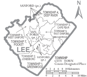
The county is divided into seven areas called townships:
- 1 (Greenwood)
- 2 (Jonesboro)
- 3 (Cape Fear)
- 4 (Deep River)
- 5 (East Sanford)
- 6 (West Sanford)
- 7 (Pocket)
Education
All public schools in Lee County are part of the Lee County Schools district.
Fun Facts About Lee County
- Historically, Lee County has been one of the top areas in the United States for making bricks.
- Cotton and tobacco are important crops grown in the county.
- The northern part of the county is in the Piedmont region. The southern part is in the Sandhills region.
- Lee County is in the middle of the Triassic Basin. This area has the most concentrated reserves of oil and natural gas in North Carolina.
- Lee County is home to the longest covered bridge in North Carolina. You can find it along NC 42 near Ole Gilliam Mill Park.
See also
 In Spanish: Condado de Lee (Carolina del Norte) para niños
 | Victor J. Glover |
 | Yvonne Cagle |
 | Jeanette Epps |
 | Bernard A. Harris Jr. |


