Pocket Creek (Deep River tributary) facts for kids
Quick facts for kids Pocket Creek |
|
|---|---|

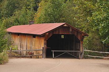
GILLIAM PARK COVERED BRIDGE, LEE COUNTY, NC
|
|
|
Location of Pocket Creek mouth
|
|
| Other name(s) | Tributary to Deep River |
| Country | United States |
| State | North Carolina |
| County | Lee |
| Physical characteristics | |
| Main source | divide between Pocket Creek, Herds Creek, and Little Crane Creek White Hill, North Carolina 475 ft (145 m) 35°23′11″N 079°16′46″W / 35.38639°N 79.27944°W |
| River mouth | Deep River about 1.5 miles south of Gulf, North Carolina 208 ft (63 m) 35°32′03″N 079°16′49″W / 35.53417°N 79.28028°W |
| Length | 16.44 mi (26.46 km) |
| Basin features | |
| Progression | north |
| River system | Deep River |
| Basin size | 37.65 square miles (97.5 km2) |
| Tributaries |
|
| Bridges | Villanow Drive, Chris Cole Road, Center Church Road, Covered Bridge Lane, Henley Road, Steel Bridge Road, Carbonton Road (NC 42) |
Pocket Creek is a stream in Lee County, North Carolina. It is about 16.44 mi (26.46 km) long. Pocket Creek flows into the Deep River. A stream that flows into a larger river is called a tributary.
One special thing about Pocket Creek is that the longest covered bridge in North Carolina crosses it. This bridge is called the Gilliam Park Covered Bridge.
Where Pocket Creek Starts and Ends
Pocket Creek begins in a pond near White Hill, North Carolina. From there, it flows north.
The creek then joins the Deep River. This meeting point is about 1.5 miles south of a town called Gulf, North Carolina.
The Land Around Pocket Creek
The area of land that drains into Pocket Creek is called its watershed. This watershed covers about 37.65 square miles (97.5 km2).
Each year, the area around Pocket Creek gets about 47.9 inches of rain and other types of precipitation. About 63% of the land in the watershed is covered by forests.
 | Janet Taylor Pickett |
 | Synthia Saint James |
 | Howardena Pindell |
 | Faith Ringgold |


