Moore County, North Carolina facts for kids
Quick facts for kids
Moore County
|
|||
|---|---|---|---|
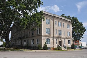
Moore County Courthouse in Carthage
|
|||
|
|||
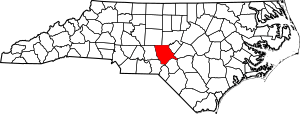
Location within the U.S. state of North Carolina
|
|||
 North Carolina's location within the U.S. |
|||
| Country | |||
| State | |||
| Founded | 1784 | ||
| Named for | Alfred Moore | ||
| Seat | Carthage | ||
| Largest community | Pinehurst | ||
| Area | |||
| • Total | 705.69 sq mi (1,827.7 km2) | ||
| • Land | 697.68 sq mi (1,807.0 km2) | ||
| • Water | 8.00 sq mi (20.7 km2) 1.13% | ||
| Population
(2020)
|
|||
| • Total | 99,727 | ||
| • Estimate
(2023)
|
106,898 | ||
| • Density | 142.94/sq mi (55.19/km2) | ||
| Time zone | UTC−5 (Eastern) | ||
| • Summer (DST) | UTC−4 (EDT) | ||
| Congressional district | 9th | ||
Moore County is a county in North Carolina, USA. In 2020, about 99,727 people lived there. The main town, or county seat, is Carthage. The biggest community is Pinehurst.
Moore County is located where two different land areas meet. These are the Piedmont and the Atlantic Coastal Plain. In the past, the county's economy relied on farming and cutting down trees. The lumber business grew a lot when railroads arrived.
Moore County is also part of the Sandhills region. This area became famous for its resorts in the late 1800s. Today, Moore County is part of a larger group of towns called the Pinehurst-Southern Pines Metropolitan Statistical Area.
Contents
History of Moore County
Native American people called Siouan lived in the Moore County area a long time ago. They were here from the 500s until the 1600s. European settlers started arriving around 1739. These settlers came from England, Scotland, and Germany. Many came along the Great Wagon Road or from the Cape Fear River valley.
Some Scottish families, known as Highlanders, settled in the southeastern part. They used the tall longleaf pines to make things like tar and pitch for ships. They also brought people from Africa to work as slaves.
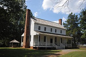
During the American Revolutionary War, fewer people moved to the area. People in the north of the county supported the American side. But the Scottish settlers in the southeast often supported the British. In July 1781, a small battle happened at the House in the Horseshoe. After the war, many British supporters faced difficulties.
Moore County was officially created in 1784. It was formed from a part of Cumberland County. The county was named after Alfred Moore. He was a soldier in the Revolutionary War. Later, he became a judge on the Supreme Court of the United States. A courthouse was built in 1785. In 1796, Carthage was chosen as the county seat. The courthouse moved there in 1814.
Many men from Moore County fought in the American Civil War. In 1877, the Raleigh and Augusta Air Line Railroad was built through the county. This led to new towns like Cameron and Aberdeen. Cutting down pine trees became a huge business. By 1900, most of the very old pine forests were gone.
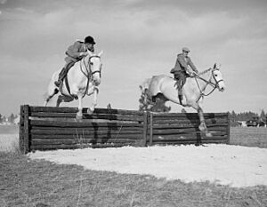
With the forests cleared and trains arriving, new health resorts appeared. Towns like Southern Pines and Pinehurst became popular. In 1897, the first golf courses were built in the county. More courses were added over time. Rich visitors from other states came to play golf. They also built vacation homes in Pinehurst and Southern Pines. Horse riding, fox hunting, and polo also became popular.
In 1907, parts of Moore and Chatham counties formed Lee County. The current Moore County Courthouse was built in 1922. In 1958, a small part of Hoke County joined Moore County.
Moore County is famous for its many golf resorts. It has hosted major golf tournaments. These include the Women's U.S. Opens and the Men's U.S. Opens. In 2014, it hosted both the men's and women's Opens in the same year. This was a first for the U.S. Open.
Geography and Nature
Moore County covers about 705 square miles. Most of this is land, with a small amount of water. It shares borders with several other counties. Moore County is mostly in the Piedmont region. But some parts reach into the state's Coastal Plain.
About two-thirds of the county has sandy soil. This is why it's called the Sandhills region. Water from the county flows into the Cape Fear River Basin. Local waterways include Pine Lake and the Deep River.
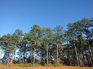
The longleaf pine tree grows naturally here. You can find these trees in the Sandhills Game Land. This is a state nature preserve. The Weymouth Woods-Sandhills Nature Preserve is also entirely within the county. Fish like bass and sunfish live in the county's waters. The red-cockaded woodpecker, an endangered bird, also lives in the area.
Population and People
In 2020, the census counted 99,727 people in Moore County. A census is a count of all the people living in an area. Most residents, about 77 percent, are white. About 10 percent are black, and 7.4 percent are Hispanic/Latino. The population in Moore County is generally older and has more white residents than the rest of North Carolina.
For the first time in 2020, several towns were grouped together. These towns include Pinehurst, Southern Pines, and Aberdeen. They now form a connected urban area. This happened because their combined population was over 50,000 people.
Population Changes Over Time
| Historical population | ||||||||||||||||||||||||||||||||||||||||||||||||||||||||||||||||||||||||||||||||||||||||||||||||||||||||||||||||
|
||||||||||||||||||||||||||||||||||||||||||||||||||||||||||||||||||||||||||||||||||||||||||||||||||||||||||||||||
Between 2010 and 2020, Moore County's population grew by over 11,000 people. Experts predict the county's population will keep growing. They think it could reach over 170,000 by 2050.
Economy
People in Moore County generally earn more money than the average for North Carolina. In 2021, the average yearly income was about $63,324. The poverty rate was around nine percent in late 2022.
The biggest job areas in Moore County are healthcare, food services, and retail. Tourism is also very important to the economy. This is mainly because of the many golf events. In 2021, tourism brought in $673 million to the county. This made it one of the top counties in North Carolina for tourism. Some residents also work at Fort Liberty, a U.S. Army base nearby. Some manufacturing jobs are also found in Moore County.
Transportation
Moore County has its own airport, the Moore County Airport. It is near Pinehurst and Southern Pines. Many people flying into the area use the Raleigh-Durham International Airport first. Then they drive to Moore County. There is also a private airport in Carthage.
Train lines run through the county. CSX Transportation operates north-south lines. Other smaller train services are also available. Amtrak has a passenger train station in Southern Pines.
Main Highways
 US 1
US 1
 US 1 Bus.
 US 15
US 15 US 501
 NC 2
NC 2 NC 5
NC 5 NC 22
NC 22 NC 24
NC 24 NC 27
NC 27 NC 73
NC 73 NC 211
 NC 690
 NC 705
Education
Public schools in Moore County are managed by Moore County Schools. About 72 percent of students attend public schools. Another 16 percent go to private or charter schools. About 11 percent of students are homeschooled.
For education after high school, there is Sandhills Community College. Its main campus is in Moore County. A program called SandHoke Early College also uses this campus. In 2021, about 40.8 percent of adults in the county had a college degree or higher.
Culture
Many people in Moore County helped develop the pottery craft in the nearby Jugtown area. The county hosts several fun events each year. These include the Moore County Agricultural Fair and the Carthage Buggy Festival. There is also the Pet Parade and the North Carolina Playwright Festival.
The Moore County Hounds club holds a traditional fox hunt each Thanksgiving Day. This event is called the Blessing of the Hounds. Moore County is very well known for its many golf courses and tournaments. Horse riding is also a very popular activity. Several buildings and places in the county are listed on the National Register of Historic Places. This means they are important historical sites.
Communities in Moore County
Towns and Cities
- Aberdeen
- Cameron
- Carthage (county seat, main town)
- Foxfire
- Pinebluff
- Pinehurst (largest community)
- Robbins
- Southern Pines
- Taylortown
- Vass
- Whispering Pines
Township Areas
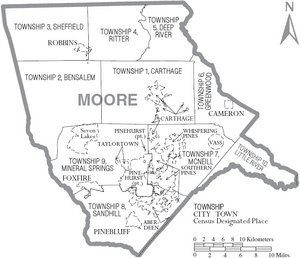
The county is divided into ten townships. These are areas with no local government power:
- Carthage
- Bensalem
- Sheffields
- Ritter
- Deep River
- Greenwood
- McNeill
- Sandhill
- Mineral Springs
- Little River
Census-Designated Places
These are areas identified by the census but not officially incorporated as towns:
Unincorporated Communities
These are smaller communities that are not officially part of any town:
- Eagle Springs
- Glendon
- High Falls
- Manly
- West End
Notable People from Moore County
- Charles Brady (1951–2006) – A doctor, Navy officer, and NASA astronaut.
- John Edwards (born 1953) – A politician, former US Senator, and presidential candidate.
- Jeff Hardy (born 1977) and Matt Hardy (born 1974) – Brothers and professional wrestlers known as The Hardy Boyz.
- Mable Parker McLean (1922–2012) – An important academic leader.
- Shannon Moore (born 1979) – A professional wrestler.
- Shanann Watts (1984–2018) – A notable person from the area.
See also
 In Spanish: Condado de Moore (Carolina del Norte) para niños
 | Selma Burke |
 | Pauline Powell Burns |
 | Frederick J. Brown |
 | Robert Blackburn |


