
Chatham County, North Carolina facts for kids
Quick facts for kids
Chatham County
|
|||||
|---|---|---|---|---|---|
_6.jpg)
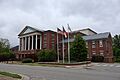
Chatham County Courthouse in Pittsboro
|
|||||
|
|||||

Location within the U.S. state of North Carolina
|
|||||
 North Carolina's location within the U.S. |
|||||
| Country | |||||
| State | |||||
| Founded | 1771 | ||||
| Named for | William Pitt, 1st Earl of Chatham | ||||
| Seat | Pittsboro | ||||
| Largest community | Siler City | ||||
| Area | |||||
| • Total | 708.93 sq mi (1,836.1 km2) | ||||
| • Land | 681.68 sq mi (1,765.5 km2) | ||||
| • Water | 27.25 sq mi (70.6 km2) 3.84% | ||||
| Population
(2020)
|
|||||
| • Total | 76,285 | ||||
| • Estimate
(2023)
|
81,624 | ||||
| • Density | 111.91/sq mi (43.21/km2) | ||||
| Time zone | UTC−5 (Eastern) | ||||
| • Summer (DST) | UTC−4 (EDT) | ||||
| Congressional district | 9th | ||||


Chatham County is a county located in the Piedmont area of North Carolina. It is also the exact center of North Carolina. This spot is found northwest of Sanford.
In 2020, about 76,285 people lived here. The main town and county seat is Pittsboro. Chatham County is part of a larger area called the Durham-Chapel Hill Metropolitan Statistical Area. This area is also part of the Raleigh-Durham-Cary Combined Statistical Area. In 2023, this larger area had about 2.3 million people.
Contents
History
Some of the first people to settle in what is now Chatham County were English Quakers. They settled along the Haw and Eno rivers. The county was officially created in 1771 from Orange County.
It was named in 1758 after William Pitt, 1st Earl of Chatham. He was the British Prime Minister from 1766 to 1768. He was known for being against harsh rules for the American colonies. In 1907, parts of Chatham County and Moore County were used to form Lee County.
A PBS documentary called Family Name talks about Chatham County. It shows how some families in the county have both white and African-American members. This happened because some men from the Alston family had children with enslaved African-American women.
George Moses Horton (1797?-1883) was a famous poet who lived most of his life in Chatham County. He was an enslaved person who published his writings while still enslaved. He is known as the Historic Poet Laureate of Chatham County.
Moncure used to be the westernmost inland port in North Carolina. This meant that steamships could travel from the coast all the way to Moncure.
On March 25, 2010, the Chatham County Courthouse caught fire. It was built in 1881 and was being renovated at the time. The courthouse has since been rebuilt. You can find more information in the article about Pittsboro, North Carolina.
Coal mining
The Deep River Coal Field runs along the southern border of Chatham County. This area has the only known coal deposits in North Carolina that could be mined for money. People mined coal here by hand in the early days of the colony. Commercial mining started in the early 1850s.
The towns of Carbonton and Cumnock grew because of the coal mining industry. Much of the coal mined here during the Civil War was used to help the Confederate army.
However, mining stopped in 1953. This was due to problems like the Coal Glen mine disaster in the 1920s. Also, the Deep River often flooded the mines. The coal was also very deep, and the layers of coal were broken up by faults in the ground.
Agriculture and industry
For a long time, farming was the main way people made a living in Chatham County. The soil here is mostly hard red clay, which is common in the Piedmont. This soil isn't great for growing cash crops like tobacco, so tobacco was never a big part of the county's economy.
Raising animals has always been more important. This includes cattle and poultry (like chickens). The county used to have many dairy farms, but most have been sold and developed recently. Chatham County is now one of the top areas in North Carolina for the poultry industry. Crops like hay are also grown in large amounts. The Carolina Farm Stewardship Association is located in Chatham County. Many organic agriculture farmers also live here, like Councilman Farms and Phillips Dairy Farms.
Industrial growth has mostly happened around Siler City and Moncure. Moncure has more industries. Companies in that area include Progress Energy, Boise Cascade, Honeywell, and Arauco. Making bricks has also been important in the Moncure area. This is because they use the local red clay soil. Several brick factories operate there and in Brickhaven.
3M runs a greenstone mine south of Pittsboro. This greenstone is used to make granules for roofing shingles. In 2007, people living in the county stopped a similar mine from being built in the western part of the county. They did not want more industrial development there.
The beautiful rural scenery has attracted many artists. The Chatham Artists Guild is active here. Tourism related to art is becoming a bigger part of the economy.
Chatham County has a strong tradition of southern music. Musicians like Tommy Thompson and Tommy Edwards have played traditional, old-time, and bluegrass music for many years. Many artists in different music styles come from this area. The Shakori Hills Grassroots Festival of Music and Dance is held twice a year, in April and October. It is a four-day outdoor festival that features many types of music. Famous artists like Patty Loveless and Ralph Stanley have performed there. Shakori Hills also hosts the Hoppin John Fiddlers Convention.
Geography
Chatham County covers about 710 square miles. About 682 square miles are land, and 28 square miles (3.9%) are water.
The county is entirely within the Piedmont region of North Carolina. The land is generally gently rolling, with some higher hills. Terrells Mountain, on the border with Orange County, is one of these hills. It is used for radio and TV station transmitters for the Raleigh-Durham area.
The county is part of the Cape Fear River drainage basin. The Cape Fear River starts in the county near Moncure. This is where the Haw River and the Deep River meet, below Jordan Lake. B. Everett Jordan Lake is a large reservoir and flood-control lake. It is mainly in eastern Chatham County. The US Army Corps of Engineers owns the lake. The state of North Carolina leases part of it as Jordan Lake State Recreation Area.
Much of the eastern part of the county is in the Triassic Basin. This is a smaller area within the Piedmont. Many of the rocks in the county came from volcanoes during the Triassic period. This is why there are coal deposits in the southern part of the county. The Boren Clay Products Pit near Gulf has fossils of Triassic plants. The volcanic origins also created a lot of metamorphic rocks in the county. The county is on the Carolina Slate Belt. The soils in the county are mostly clay-based and have a deep red color, like most soils in the Piedmont.
The groundwater in the county often has many minerals, making it "hard" unless it is softened. In the late 1800s and early 1900s, people were attracted to Mt. Vernon Springs because of its mineral water. A resort spa was built there. Visitors would drink the water, hoping it would cure illnesses. The resort closed in the early 1900s and is no longer there. The springs still exist and are cared for by a local church.
Adjacent counties
- Orange County - north
- Durham County - northeast
- Wake County - east
- Harnett County - southeast
- Lee County - south
- Moore County - southwest
- Randolph County - west
- Alamance County - northwest
Parks and recreation
The towns of Pittsboro, Siler City, and Goldston have their own parks and recreation places.
State parks, game land, trails, and recreation areas
- Chatham Game Land
- Deep River State Trail
- Harris Game Land (part)
- Jordan Game Land (part)
- Jordan Lake Educational State Forest
- Jordan Lake State Recreation Area (including Crosswinds Campground, Ebenezer Church, Parker's Creek, Poplar Point, Seaforth area, Vista Point, Robeson Creek, New Hope Overlook, and White Oak Recreation Areas)
- Lee Game Land (part)
- Lower Haw River State Natural Area
- Robeson Creek Boat Access
- Robeson Creek Paddle Access
County parks, trails, and recreation areas
- 15-501 Haw River Canoe Access
- American Tobacco Trail
- Briar Chapel Sports Park
- Bynum Beach Haw River Paddle Access
- Earl Thompson Park
- Northeast District Park
- Northwest District Park
- Southeast District Park
- Southwest Community Park
- US 64 Haw River Paddle Access
Other attractions
- Carnivore Preservation Trust
- Condoret Nature Preserve
- Crosswinds Marina
- Deep River Park and the Deep River Camelback Truss Bridge
- Irvin Nature Preserve
- La Grange Riparian Reserve
- McIver Landing
- New Hope Valley Railway
- Shakori Hills Grassroots Festival
- White Pines Nature Preserve (part)
- Wood's Mill Bend
Demographics
| Historical population | |||
|---|---|---|---|
| Census | Pop. | %± | |
| 1790 | 9,161 | — | |
| 1800 | 11,861 | 29.5% | |
| 1810 | 12,977 | 9.4% | |
| 1820 | 12,661 | −2.4% | |
| 1830 | 15,405 | 21.7% | |
| 1840 | 16,242 | 5.4% | |
| 1850 | 18,449 | 13.6% | |
| 1860 | 19,101 | 3.5% | |
| 1870 | 19,723 | 3.3% | |
| 1880 | 23,453 | 18.9% | |
| 1890 | 25,413 | 8.4% | |
| 1900 | 23,912 | −5.9% | |
| 1910 | 22,635 | −5.3% | |
| 1920 | 23,814 | 5.2% | |
| 1930 | 24,177 | 1.5% | |
| 1940 | 24,726 | 2.3% | |
| 1950 | 25,392 | 2.7% | |
| 1960 | 26,785 | 5.5% | |
| 1970 | 29,554 | 10.3% | |
| 1980 | 33,415 | 13.1% | |
| 1990 | 38,759 | 16.0% | |
| 2000 | 49,329 | 27.3% | |
| 2010 | 63,505 | 28.7% | |
| 2020 | 76,285 | 20.1% | |
| 2023 (est.) | 81,624 | 28.5% | |
| U.S. Decennial Census 1790–1960 1900–1990 1990–2000 2010 2020 |
|||
2020 census
In 2020, there were 76,285 people living in Chatham County. There were 30,674 households and 21,406 families.
Population details
In 2000, about 22.5% of the people were under 18 years old. About 15.3% were 65 years or older. The average age was 39 years. For every 100 females, there were about 96.8 males.
One area in Chatham County, which includes two retirement communities, was found to have the highest average lifespan in the United States. People there lived to an average age of 97.5 years!
Education
Chatham County helps pay for public schools and community colleges, but it does not run them directly. The Chatham County School System has its own elected board that makes decisions. There are four public high schools in the county:
- Seaforth in Pittsboro
- Northwood in Pittsboro
- Jordan-Matthews in Siler City
- Chatham Central in Bear Creek
Chatham County also has three charter schools. These are public schools that have more freedom in how they operate.
- Woods Charter School (K-12)
- Chatham Charter High School (K-12)
- Willow Oak Montessori Charter School (grades 1-8)
Woods Charter School moved into a new building in 2008. It has ranked among the top ten schools in North Carolina for SAT scores. Chatham Charter High School is located in Siler City. Willow Oak Montessori Charter School is a tuition-free public school in Central Chatham County.
Central Carolina Community College has two campuses in the county. It is managed by its own Board of Trustees.
The county gives a lot of its money to public education. For example, in 2007–08, over 39% of the county's tax money went to education. The county has been ranked high in North Carolina for how much it spends per student.
Transportation
Chatham County has kept its rural feel partly because it does not have an Interstate Highway. However, it is important for transportation in the region. This is because it is near the center of North Carolina and close to big cities like Raleigh, Durham, and Greensboro. Most people drive because of the county's rural nature. But residents also have other ways to get around.
Major highways


 Future I-685
 US 1
US 1 US 15
US 15 US 64
US 64
US 64 Bus. US 421
 US 501
 NC 22
NC 22 NC 42
NC 42 NC 87
NC 87 NC 751
 NC 902
The main road that goes east and west through Chatham County is U.S. 64. It connects to Siler City and Pittsboro. U.S. Routes 421 and 15–501 go north and south. U.S. 421 serves Siler City, and U.S. 15–501 serves Pittsboro. In the 1990s and early 2000s, the NCDOT spent a lot of money to make these roads wider. They used to be two-lane roads but are now multi-lane highways. There is now a U.S. 64 bypass around Pittsboro. A similar highway helps traffic avoid Siler City on U.S. 421.
Transit
Chatham County has two public transportation services: Chatham Transit Network and Chapel Hill Transit. Chatham Transit Network (CTN) offers bus routes and rides for people needing special help. CTN's bus route runs on weekdays between Siler City, Pittsboro, and Chapel Hill.
Chatham County has many nice bike routes along its rural roads. The American Tobacco Trail also goes through the northeast part of the county.
The Raleigh–Durham International Airport (RDU) is nearby and serves Chatham County. The Siler City Municipal Airport is a public airport located about 3 miles southwest of downtown Siler City. It is home to several small airplanes.
The county also has train services from both Norfolk Southern Railway and CSX Transportation. Norfolk Southern serves Siler City, Bonlee, Bear Creek, and Goldston. CSX serves the Moncure area.
Healthcare
UNC Health operates Chatham Hospital in Siler City. They also run several other special clinics in the county.
Media
Newspapers
- Chatham County Events (an online calendar, blog, and directory)
- The Chatham County News
- Chatham Journal (weekly, based in Pittsboro)
- The Chatham News (weekly, based in Siler City)
- The Chatham Record (weekly, based Pittsboro)
- Chatham County Line (published 10 times a year)
Television
- WTVD (ABC channel)
- WRAL-TV (NBC channel)
- WGHP (FOX channel) High Point
- WNCN (CBS channel) Raleigh-Durham
- WFMY (CBS channel) Greensboro
- WRAZ (FOX channel) Raleigh-Durham
- WLFL (CW channel)
- WRDC (MyNetwork channel)
- WUNC (PBS channel)
- WUVC (Univision channel – Spanish language)
- WRPX (ION channel)
Communities

Towns
- Apex (mostly in Wake County)
- Cary (mostly in Wake County)
- Chapel Hill (mostly in Orange County)
- Goldston
- Pittsboro
- Siler City
Townships
- Albright
- Baldwin
- Bear Creek
- Cape Fear
- Center
- Gulf
- Hadley
- Haw River
- Hickory Mountain
- Matthews
- New Hope
- Oakland
- Williams
Census-designated places
Unincorporated communities
Images for kids
-
Chatham County Courthouse in Pittsboro
See also
 In Spanish: Condado de Chatham (Carolina del Norte) para niños
