Durham County, North Carolina facts for kids
Quick facts for kids
Durham County
|
|||||
|---|---|---|---|---|---|
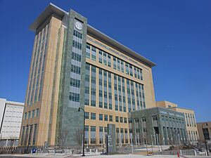
Durham County Courthouse
|
|||||
|
|||||
| Motto(s):
"Live. Grow. Thrive."
|
|||||
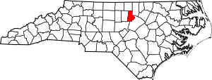
Location within the U.S. state of North Carolina
|
|||||
 North Carolina's location within the U.S. |
|||||
| Country | |||||
| State | |||||
| Founded | 1881 | ||||
| Named for | Bartlett Snipes Durham | ||||
| Seat | Durham | ||||
| Largest community | Durham | ||||
| Area | |||||
| • Total | 297.86 sq mi (771.5 km2) | ||||
| • Land | 286.53 sq mi (742.1 km2) | ||||
| • Water | 11.33 sq mi (29.3 km2) 3.80% | ||||
| Population
(2020)
|
|||||
| • Total | 324,833 | ||||
| • Estimate
(2023)
|
336,892 |
||||
| • Density | 1,090.556/sq mi (421.066/km2) | ||||
| Time zone | UTC−5 (Eastern) | ||||
| • Summer (DST) | UTC−4 (EDT) | ||||
| Congressional district | 4th | ||||
Durham County is a county in North Carolina, a state in the United States. In 2020, about 324,833 people lived here. This makes it the sixth-most populated county in North Carolina.
The main city and county seat is Durham. Most of Durham County is part of the city of Durham. Some small parts of other cities are also in the county. The middle and southern parts of Durham County are very city-like. They include the city of Durham and its nearby areas.
The Research Triangle Park is a big science and technology area. Most of it is in Durham County. The northern part of Durham County is more rural, meaning it has more farms and open land. Durham County is also a key part of a larger area called the Research Triangle. This area includes the cities of Raleigh, Durham, and Chapel Hill.
Contents
History of Durham County
Durham County was created on April 17, 1881. It was formed from parts of Orange County and Wake County. The county was named after its main city, Durham. In 1911, more land from Wake County was added to Durham County. This new area became Carr Township.
Geography of Durham County
Durham County covers about 297.86 square miles. Most of this area, about 286.53 square miles, is land. The rest, about 11.33 square miles, is water.
Parks and Protected Areas
Durham County has many natural and historic places. These areas help protect nature and tell us about the past.
- Bennett Place State Historic Site
- Butner-Falls of Neuse Game Land (part)
- Duke Homestead and Tobacco Factory
- East Durham Historic District
- Eno River State Park (part)
- Falls Lake State Recreation Area (part)
- Historic Stagville
- Hollow Rock Nature Park (part)
- Horton Grove Nature Preserve
- Jordan Game Land (part)
- Little River Regional Park and Natural Area (part)
- Mason Farm Biological Reserve (part)
- Museum of Life and Science
- Rolling View State Recreation Area (part)
Rivers and Lakes
Many important rivers and lakes are found in Durham County. They are important for nature and for people.
- B. Everett Jordan Lake
- Crabtree Creek
- Ellerbe Creek
- Eno River
- Falls Lake
- Flat River
- Lake Michie
- Little River
- New Hope Creek
- Stirrup Iron Creek
Neighboring Counties
Durham County shares borders with several other counties.
- Person County – to the north
- Granville County – to the northeast
- Wake County – to the east-southeast
- Chatham County – to the south
- Orange County – to the west
Main Roads
Many major roads pass through Durham County. These roads help people travel and connect different areas.
 I-40
I-40 I-85
I-85


 I-540 / NC 540 Toll


 I-885 / NC 885 Toll
 US 15
US 15
 US 15 Bus.
 US 70
US 70
 US 70 Bus. (Durham)
 US 70 Bus. (to Orange County)
 US 501
 NC 54
NC 54 NC 55
NC 55 NC 98
NC 98 NC 147
 NC 157
 NC 751
 NC 751 Truck (truck route)
Important Buildings
- Durham Station is a key transportation hub.
People of Durham County
| Historical population | |||
|---|---|---|---|
| Census | Pop. | %± | |
| 1890 | 18,041 | — | |
| 1900 | 26,233 | 45.4% | |
| 1910 | 35,276 | 34.5% | |
| 1920 | 42,219 | 19.7% | |
| 1930 | 67,196 | 59.2% | |
| 1940 | 80,244 | 19.4% | |
| 1950 | 101,639 | 26.7% | |
| 1960 | 111,995 | 10.2% | |
| 1970 | 132,681 | 18.5% | |
| 1980 | 152,785 | 15.2% | |
| 1990 | 181,835 | 19.0% | |
| 2000 | 223,314 | 22.8% | |
| 2010 | 267,587 | 19.8% | |
| 2020 | 324,833 | 21.4% | |
| 2023 (est.) | 336,892 | 25.9% | |
| U.S. Decennial Census 1790–1960 1900–1990 1990–2000 2010–2020 |
|||
Population in 2020
In 2020, the census counted 324,833 people living in Durham County. There were 131,140 households and 75,291 families. The county is home to a diverse group of people.
| Group | Number of People | Percentage |
|---|---|---|
| White (not Hispanic) | 133,768 | 41.18% |
| Black or African American (not Hispanic) | 109,225 | 33.62% |
| Native American | 704 | 0.22% |
| Asian | 16,707 | 5.14% |
| Pacific Islander | 83 | 0.03% |
| Other/Mixed | 14,242 | 4.38% |
| Hispanic or Latino | 50,104 | 15.42% |
Communities in Durham County
The city of Durham is the main city in Durham County. It is the only city that is mostly within the county. However, small parts of other cities from nearby counties also reach into Durham County. All other towns and places in Durham County are unincorporated. This means they are not officially organized as cities or towns.
Cities
- Durham (This is the county seat and largest community. Small parts of it are also in Wake and Orange counties.)
- Raleigh (Most of this city is in Wake County.)
Towns
- Chapel Hill (Most of this town is in Orange County.)
- Morrisville (Most of this town is in Wake County.)
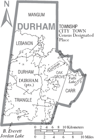
Townships
Townships are smaller areas within a county.
- Carr
- Durham
- Lebanon
- Mangum
- Oak Grove
- Triangle
Census-designated Places
These are areas that are like towns but are not officially incorporated.
Unincorporated Communities
These are smaller communities that are not part of any city or town.
Notable Person
- Margaret O'Neal (1884–?), a sharecropper who lived in the area.
See also
 In Spanish: Condado de Durham (Carolina del Norte) para niños
 | Valerie Thomas |
 | Frederick McKinley Jones |
 | George Edward Alcorn Jr. |
 | Thomas Mensah |


