Crabtree Creek (Neuse River tributary) facts for kids
Quick facts for kids Crabtree Creek |
|
|---|---|

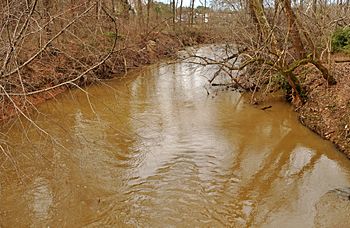
Crabtree Creek east of Lassiter Mill Rd.
|
|
|
Location of Crabtree Creek mouth
|
|
| Other name(s) | Tributary to Neuse River |
| Country | United States |
| State | North Carolina |
| County | Wake |
| City | Raleigh Cary |
| Physical characteristics | |
| Main source | between Cary, North Carolina and Apex, North Carolina, southwest of Bond Park Cary, North Carolina 450 ft (140 m) 35°45′30″N 078°50′41″W / 35.75833°N 78.84472°W |
| River mouth | Neuse River about 2 miles southeast of Wilders Grove, North Carolina 157 ft (48 m) 35°45′59″N 078°32′22″W / 35.76639°N 78.53944°W |
| Length | 28.73 mi (46.24 km) |
| Basin features | |
| Progression | north, east, then southeast |
| River system | Neuse River |
| Basin size | 145.27 square miles (376.2 km2) |
| Tributaries | |
| Waterbodies | Lake Crabtree Bond Lake |
Crabtree Creek is a stream in Wake County, North Carolina, United States. It's a tributary, which means it's a smaller stream that flows into a larger river. Crabtree Creek flows into the Neuse River.
The creek starts in Cary and travels through Morrisville, William B. Umstead State Park, and the northern parts of Raleigh. It then joins the Neuse River at Anderson Point Park in East Raleigh.
The area around Crabtree Creek is a floodplain. This means it's a flat area next to the creek that often gets covered with water when there's a lot of rain. Even though lakes like Lake Crabtree were built to help control floods, the problem still happens. This is because Wake County has grown a lot, and more buildings and roads mean more rainwater runs off into the creek.
Crabtree Valley Mall is named after the creek. When the mall was built, the creek was moved into a new, artificial channel behind it. However, this new channel isn't always big enough for all the water when it rains heavily.
Contents
Flooding at Crabtree Creek
Crabtree Creek has flooded many times, especially near Crabtree Valley Mall. The highest water level ever recorded at Glenwood Avenue was about 27.7 feet in June 1973. This happened shortly after the mall was finished.
Other big floods occurred during Tropical Storm Alberto (2006) and Hurricane Fran in September 1996. All these events caused the lower level of the mall to flood. They also covered the parking lots and made it hard for cars to get around. Even smaller storms can cause problems around the mall, like in June 2006 when the mall had to be evacuated.
Lakes and Parks Along the Creek
In the Cary and Morrisville area, a dam was built on the creek to create Lake Crabtree. This lake is about 520 acres and helps control floods. Many places are named after the creek or the lake, like Lake Crabtree County Park and Raleigh's Crabtree Boulevard.
The Crabtree Creek Trail is a popular walking and biking path. It's part of the Capital Area Greenway system. This trail follows the creek from west of Crabtree Valley Mall all the way to where it meets the Neuse River at Anderson Point Park.
Lassiter Mill History
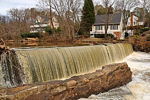
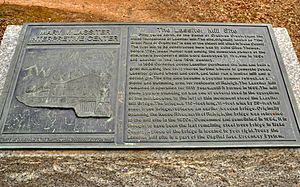
One of the first mills in Wake County was located on Crabtree Creek. It was at a spot known as "the Great Falls of Crabtree." The very first mill was built before 1764. The foundations you see today are from a grist mill built by Cornelius Jesse Lassiter in 1908. A grist mill is a place where grain is ground into flour.
Sadly, the mill was destroyed by fire in 1958. Today, the Lassiter Mill site is a park in Raleigh. It's part of the greenway system and is open for everyone to visit.
Crabtree Creek Greenway Trail
The Crabtree Creek greenway is a paved trail that is about 14.6 miles (23.5 km) long. It follows Crabtree Creek from Anderson Point Park, where it connects to the Neuse River Trail, all the way to Lindsay Drive.
A new section of the trail was finished in 2015, connecting the existing trail to the Neuse River Trail. There are also plans to extend the trail even further west to William B. Umstead State Park. Once completed, the Crabtree Creek Trail will stretch across the city. It will connect many important places like Umstead State Park, Crabtree Valley Mall, Shelley Lake, and other parks.
Crabtree Creek Watershed
A watershed is an area of land where all the water drains into a single river or stream. The Crabtree Creek watershed covers about 145 square miles. This means all the rain that falls in this large area eventually flows into Crabtree Creek.
Tributaries of Crabtree Creek
Crabtree Creek has many smaller streams, called tributaries, that flow into it. These tributaries collect water from different parts of the watershed and bring it to the main creek. Some of the larger tributaries include:
- Stirrup Iron Creek: This is the largest tributary to Crabtree Creek. It flows into Lake Crabtree.
- Sycamore Creek: This creek flows through William B. Umstead State Park and has two lakes, Big Lake and Sycamore Lake.
- Mine Creek: This creek flows through Shelley Lake before joining Crabtree Creek.
- Marsh Creek: This creek rises near Northridge Country Club and flows southeast to Crabtree Creek.
- House Creek: This creek starts near North Carolina State University and flows towards Crabtree Creek near Crabtree Valley Mall.
These are just a few of the many streams that contribute to Crabtree Creek, helping to form its path through Wake County.
 | Chris Smalls |
 | Fred Hampton |
 | Ralph Abernathy |


