Randolph County, North Carolina facts for kids
Quick facts for kids
Randolph County
|
|||||
|---|---|---|---|---|---|

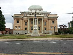
Randolph County Courthouse and Confederate Monument
|
|||||
|
|||||
| Motto(s):
"Serving with Heart from the Heart of North Carolina"
|
|||||

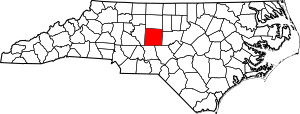
Location within the U.S. state of North Carolina
|
|||||
 North Carolina's location within the U.S. |
|||||
| Country | |||||
| State | |||||
| Founded | 1779 | ||||
| Named for | Peyton Randolph | ||||
| Seat | Asheboro | ||||
| Largest community | Asheboro | ||||
| Area | |||||
| • Total | 790.01 sq mi (2,046.1 km2) | ||||
| • Land | 782.38 sq mi (2,026.4 km2) | ||||
| • Water | 7.63 sq mi (19.8 km2) 0.97% | ||||
| Population
(2020)
|
|||||
| • Total | 144,171 | ||||
| • Estimate
(2023)
|
147,458 | ||||
| • Density | 184.27/sq mi (71.15/km2) | ||||
| Time zone | UTC−5 (Eastern) | ||||
| • Summer (DST) | UTC−4 (EDT) | ||||
| Congressional district | 9th | ||||
Randolph County is a county in the state of North Carolina, USA. In 2020, about 144,171 people lived there. The main town and county seat is Asheboro.
Randolph County is part of the larger Greensboro-High Point area. This area is a big center for jobs and living in North Carolina. In 2020, the exact middle point of North Carolina's population was found in Randolph County, near Seagrove.
Contents
History of Randolph County
Early Inhabitants and Founding
Long ago, Siouan Native Americans lived in the area that is now Randolph County. These included the Saponi and Keyauwee tribes. In the 1700s, people from Europe started moving in. Many were from Germany, Scotland, Ireland, and England. Some of these settlers were Quakers or Moravians, who are Christian groups.
In 1779, the government decided to create a new county. They took parts of Guilford and Rowan counties. They named it Randolph County after Peyton Randolph. He was the first president of the Continental Congress, a group of leaders before the United States became a country.
Life Before the Civil War
Before the American Civil War (a war fought in the U.S. from 1861 to 1865), Randolph County was not very rich. Most people were small farmers who owned their land.
Randolph County During the Civil War
The Civil War caused many disagreements in the county. Many Quakers living there did not believe in fighting. They were called pacifists. Also, poorer men who were forced to join the army were unhappy. Richer officers often did not have to fight. This led many people to refuse to join the army.
In 1864, Randolph County was one of only three counties in the state to vote for William Woods Holden. He wanted peace and an end to the war. Many men who were supposed to fight for the Confederate Army ran away. A group called the Heroes of America helped hide them. Because of this, the state government sent troops in 1863 to find them.
By late 1864, fewer people were running away. But in early 1865, more men started to desert again. Local soldiers who were supposed to keep order were afraid to force people to join the army. Some leaders even doubted if their own soldiers were loyal. To help, the state sent 600 troops to the county in March 1865. They also offered deals to the men who had run away.
After the Civil War
After the war, people who had supported the Union (the northern states) took control of the county government. They used their new power to punish those who had forced people to join the Confederate army.
From 1868 to 1872, a group called the Ku Klux Klan was active in North Carolina. This group was against equal rights for all people. Even with the Klan, most white people in Randolph County still supported the Republican Party.
After the war, the textile industry grew in Randolph County. New factories that made cloth were built along the Deep River.
A New County Idea
In 1911, there was an idea to create a new county called Piedmont County. It would have included parts of Guilford, Davidson, and Randolph counties. High Point would have been its main town. Many people in Guilford County did not like this idea. They went to the courthouse to protest. The state government voted against the plan in February 1911.
Geography of Randolph County
Randolph County covers about 790 square miles. Most of this is land, with a small amount of water. It shares borders with six other counties: Guilford, Alamance, Chatham, Moore, Montgomery, and Davidson.
Randolph County is right in the middle of North Carolina. The city of Asheboro is considered the center point of the state. The county is in the Piedmont region. This area has gentle rolling hills and many trees.
The central and western parts of the county have the Uwharrie Mountains and the Caraway Mountains. These mountains are what is left of very old, much taller peaks. Today, they are usually less than 1,000 feet high. But they still rise 200 to 500 feet above the land around them.
The highest point in Randolph County is Shepherd Mountain, which is in the Caraway Mountains. The North Carolina Zoo is located on Purgatory Mountain, one of the Uwharrie peaks.
Protected Natural Areas
Randolph County has several important natural areas:
- Birkhead Mountains Wilderness
- Uwharrie National Forest
Local Parks and Sites
- North Carolina Zoo
- Pisgah Covered Bridge
- Uwharrie Game Land (part of it)
Major Rivers and Lakes
- Back Creek
- Bush Creek
- Caraway Creek
- Deep River
- Little Caraway Creek
- Little River
- Little Uwharrie River
- Randleman Lake
- Reed Creek
- Rocky River
- Toms Creek
- Uwharrie River
Main Roads and Highways
 I-73
I-73 I-74
I-74 I-85
I-85


 Future I-685
 US 29
US 29 US 64
US 64
 US 64 Bus.
 US 70
US 70 US 220


 US 220 Alt.


 US 220 Bus.
 US 311
 US 421
 NC 22
NC 22 NC 42
NC 42 NC 47
NC 47 NC 49
NC 49 NC 62
NC 62 NC 109
 NC 134
 NC 159
 NC 159 Spur
 NC 705
Important Transportation Hubs
- Asheboro Regional Airport
Population of Randolph County
| Historical population | |||
|---|---|---|---|
| Census | Pop. | %± | |
| 1790 | 7,318 | — | |
| 1800 | 9,234 | 26.2% | |
| 1810 | 10,112 | 9.5% | |
| 1820 | 11,331 | 12.1% | |
| 1830 | 12,406 | 9.5% | |
| 1840 | 12,875 | 3.8% | |
| 1850 | 15,832 | 23.0% | |
| 1860 | 16,793 | 6.1% | |
| 1870 | 17,551 | 4.5% | |
| 1880 | 20,836 | 18.7% | |
| 1890 | 25,195 | 20.9% | |
| 1900 | 28,232 | 12.1% | |
| 1910 | 29,491 | 4.5% | |
| 1920 | 30,856 | 4.6% | |
| 1930 | 36,259 | 17.5% | |
| 1940 | 44,554 | 22.9% | |
| 1950 | 50,804 | 14.0% | |
| 1960 | 61,497 | 21.0% | |
| 1970 | 76,358 | 24.2% | |
| 1980 | 91,728 | 20.1% | |
| 1990 | 106,546 | 16.2% | |
| 2000 | 130,454 | 22.4% | |
| 2010 | 141,752 | 8.7% | |
| 2020 | 144,171 | 1.7% | |
| 2023 (est.) | 147,458 | 4.0% | |
| U.S. Decennial Census 1790–1960 1900–1990 1990–2000 2010 2020 |
|||
2020 Census Information
In 2020, there were 144,171 people living in Randolph County. There were 56,117 households and 37,795 families.
Here is a breakdown of the different groups of people living in Randolph County in 2020:
| Group | Number of People | Percentage |
|---|---|---|
| White (not Hispanic) | 108,354 | 75.16% |
| Black or African American (not Hispanic) | 8,592 | 5.96% |
| Native American | 666 | 0.46% |
| Asian | 2,158 | 1.5% |
| Pacific Islander | 10 | 0.01% |
| Other/Mixed Race | 5,340 | 3.7% |
| Hispanic or Latino | 19,051 | 13.21% |
Economy of Randolph County
Randolph County's economy mainly relies on manufacturing. This means many businesses make products in factories. In 2024, the North Carolina Department of Commerce said Randolph was one of the state's 20 counties with the fewest economic problems. This means it is a strong economic area.
Education in Randolph County
Most schools in Randolph County are part of the Randolph County School System. However, the city of Asheboro has its own school system, called Asheboro City Schools.
Fayetteville Street Christian School in Asheboro is the largest private school in the county.
Culture in Randolph County
Making pottery has been a popular tradition in the Seagrove area of Randolph County for a long time. Every year, people celebrate this art at the Seagrove Pottery Festival.
Communities in Randolph County
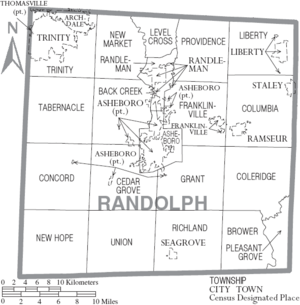
Cities
- Archdale (part of it)
- Asheboro (the main town and county seat)
- High Point (part of it)
- Randleman
- Thomasville (part of it)
- Trinity
Towns
Townships
- Asheboro
- Archdale
- Back Creek
- Brower
- Cedar Grove
- Coleridge
- Columbia
- Concord
- Farmer
- Franklinville
- Grant
- Level Cross
- Liberty
- New Hope
- New Market
- Pleasant Grove
- Providence
- Randleman
- Richland
- Tabernacle
- Trinity
- Union
Unincorporated Communities
These are smaller communities that are not officially cities or towns.
Notable People from Randolph County
- Sam Ard, a NASCAR race car driver
- Jerry Bledsoe, an author
- Heidi N Closet, a famous drag queen
- Braxton Craven, an educator and the second president of Duke University
- Heaven Fitch, a wrestler
- Rufus Hussey, a skilled marksman
- Henderson Luelling, a Quaker who was against slavery and grew plants
- Gideon Morris, a pioneer who helped settle areas west of the Appalachian Mountains
- Adam Petty, a NASCAR driver
- Kyle Petty, a NASCAR driver
- Lee Petty, a pioneer in NASCAR racing
- Richard Petty, a famous NASCAR driver
- Naomi Wise, a person who was murdered
- Jonathan Worth, a former Governor of North Carolina
See also
 In Spanish: Condado de Randolph (Carolina del Norte) para niños
 | Misty Copeland |
 | Raven Wilkinson |
 | Debra Austin |
 | Aesha Ash |


