Rocky River (North Carolina) facts for kids
Quick facts for kids Rocky River |
|
|---|---|

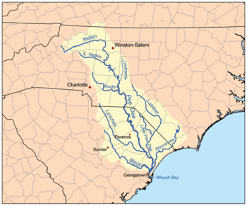
Map of the Pee Dee River watershed showing the Rocky River
|
|
|
Location of Rocky River mouth
|
|
| Other name(s) | Tributary to Pee Dee River |
| Country | United States |
| State | North Carolina |
| County | Anson Cabarrus Iredell Mecklenburg Richmond Stanly Union |
| Physical characteristics | |
| Main source | divide between Rocky River and Catawba River Mooresville, North Carolina 885 ft (270 m) 35°35′01″N 080°47′15″W / 35.58361°N 80.78750°W |
| River mouth | Pee Dee River about 3 miles northeast of Ansonville, North Carolina 190 ft (58 m) 35°08′36″N 080°04′35″W / 35.14333°N 80.07639°W |
| Length | 94.16 mi (151.54 km) |
| Basin features | |
| Progression | generally southeast |
| River system | Pee Dee River |
| Basin size | 1,471.3 square miles (3,811 km2) |
| Tributaries |
|
The Rocky River is a river in North Carolina, about 95 miles (153 km) long. It flows through the Piedmont region. The river starts in Iredell County near Mooresville. It then flows south into Cabarrus County.
The Rocky River is the main waterway in Cabarrus County. It continues flowing southeast. The river forms the border between Stanly, Union, and Anson counties. It eventually joins the Pee Dee River near Norwood, North Carolina. This meeting point is at the base of the Uwharrie Mountains.
Exploring the Rocky River
The Rocky River is a great place for outdoor fun. People are working to make it even better for visitors. They want to encourage activities like canoeing and kayaking.
The Rocky River Blueway
The river is part of something called the "Rocky River Blueway." This Blueway is a special water trail. It is part of the larger Carolina Thread Trail project. This project aims to connect communities with greenways and blueways.
River Access and Parks
Groups that are not part of the government have helped create parks along the river. These parks make it easier for people to get to the river. They help everyone enjoy the natural beauty of the area.
 | Emma Amos |
 | Edward Mitchell Bannister |
 | Larry D. Alexander |
 | Ernie Barnes |


