Stanly County, North Carolina facts for kids
Quick facts for kids
Stanly County
|
|||
|---|---|---|---|
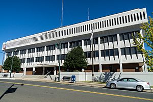
Stanly County Courthouse in Albemarle
|
|||
|
|||
| Motto(s):
"Water, Air, Land, Success"
|
|||
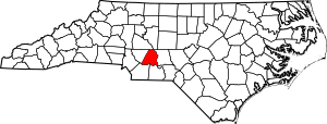
Location within the U.S. state of North Carolina
|
|||
 North Carolina's location within the U.S. |
|||
| Country | |||
| State | |||
| Founded | 1841 | ||
| Named for | John Stanly | ||
| Seat | Albemarle | ||
| Largest municipality | Albemarle | ||
| Area | |||
| • Total | 404.81 sq mi (1,048.5 km2) | ||
| • Land | 395.08 sq mi (1,023.3 km2) | ||
| • Water | 9.73 sq mi (25.2 km2) 2.40% | ||
| Population
(2020)
|
|||
| • Total | 62,504 | ||
| • Estimate
(2023)
|
65,699 | ||
| • Density | 158.21/sq mi (61.09/km2) | ||
| Time zone | UTC−5 (Eastern) | ||
| • Summer (DST) | UTC−4 (EDT) | ||
| Congressional district | 8th | ||
Stanly County is a county located in the state of North Carolina in the United States. In 2020, about 62,504 people lived here. The main town and county seat is Albemarle.
Stanly County is part of a larger area called the Albemarle, NC Micropolitan Statistical Area. This area is also connected to the Charlotte-Concord, NC-SC Combined Statistical Area.
Contents
History of Stanly County
The land where Stanly County is today was first home to small groups of people who hunted and gathered food. There were also "Mound Builders" who created large earth mounds. We know this from artifacts and settlements found that are nearly 10,000 years old!
Later, in the mid-1700s, many European settlers came to this region. Some came from Pennsylvania and New Jersey. They were Dutch, Scots-Irish, and German, and they were looking for more freedom to practice their religion and have a say in government. Others came from Virginia and eastern North Carolina. These settlers were mostly of English background.
In the early days of the English colonies, the Stanly County area was part of a larger region called New Hanover Precinct. This area was later divided, and in 1734, Bladen Precinct was created. Bladen County was then divided to create Anson County in 1750. Finally, Montgomery County was formed from Anson County in 1779.
Stanly County was officially created in 1841. It was formed from the western part of Montgomery County, located west of the Pee Dee River. The county was named after John Stanly. He was a politician from New Bern (1774–1834). John Stanly served in the North Carolina House of Commons and also for two terms in the United States House of Representatives.
Geography and Location
The United States Census Bureau says that Stanly County covers about 405 square miles. Most of this (about 395 square miles) is land, and about 9.8 square miles (2.4%) is water.
Neighboring Counties
Stanly County shares its borders with several other counties:
- Rowan County to the north
- Davidson County to the northeast
- Montgomery County to the east
- Anson County to the south
- Union County to the south
- Cabarrus County to the west
Main Roads and Highways
Many important roads pass through Stanly County, connecting it to other areas:
 US 52
US 52 NC 8
NC 8 NC 24
NC 24 NC 27
NC 27 NC 73
NC 73 NC 109
 NC 49
NC 49 NC 138
 NC 200
 NC 205
 NC 731
 NC 740
 NC 742
Population and People
| Historical population | |||
|---|---|---|---|
| Census | Pop. | %± | |
| 1850 | 6,922 | — | |
| 1860 | 7,801 | 12.7% | |
| 1870 | 8,315 | 6.6% | |
| 1880 | 10,505 | 26.3% | |
| 1890 | 12,136 | 15.5% | |
| 1900 | 15,220 | 25.4% | |
| 1910 | 19,909 | 30.8% | |
| 1920 | 27,429 | 37.8% | |
| 1930 | 30,216 | 10.2% | |
| 1940 | 32,834 | 8.7% | |
| 1950 | 37,130 | 13.1% | |
| 1960 | 40,873 | 10.1% | |
| 1970 | 42,822 | 4.8% | |
| 1980 | 48,517 | 13.3% | |
| 1990 | 51,765 | 6.7% | |
| 2000 | 58,100 | 12.2% | |
| 2010 | 60,600 | 4.3% | |
| 2020 | 62,504 | 3.1% | |
| 2023 (est.) | 65,699 | 8.4% | |
| U.S. Decennial Census 1790–1960 1900–1990 1990–2000 2010–2020 |
|||
2020 Census Information
The 2020 United States census counted 62,504 people living in Stanly County. There were 23,332 households and 16,569 families.
| Race | Number | Percentage |
|---|---|---|
| White (non-Hispanic) | 48,645 | 77.83% |
| Black or African American (non-Hispanic) | 7,000 | 11.2% |
| Native American | 210 | 0.34% |
| Asian | 1,140 | 1.82% |
| Pacific Islander | 9 | 0.01% |
| Other/Mixed | 2,414 | 3.86% |
| Hispanic or Latino | 3,086 | 4.94% |
Education in Stanly County
Stanly County has many schools for students of all ages, from elementary to college.
Elementary Schools
- Aquadale Elementary "Little Bulls"
- Badin Elementary "Watts"
- Carolina Christian School "Lions"
- Central Elementary "Bulldogs"
- East Albemarle Elementary "Bullpups"
- Endy Elementary "Redhawks"
- Locust Elementary "Colts"
- Millingport Elementary "Wildcats"
- Norwood Elementary "Patriots"
- Oakboro Elementary "Eagles"
- Richfield Elementary "Tigers"
- Stanfield Elementary "Wildcats"
Middle Schools
- Albemarle Middle School "Bulldogs"
- Carolina Christian School "Lions"
- North Stanly Middle School "Comets"
- South Stanly Middle School "Rebels"
- West Stanly Middle School "Colts"
High Schools
- Carolina Christian School "Lions"
- Gray Stone Day School "Knights"
- North Stanly High School "Comets"
- South Stanly High School "Bulls"
- Albemarle High School "Bulldogs"
- Stanly Early College "Tigers"
- West Stanly High School "Colts"
- Stanly Academy Learning Center
Colleges and Universities
- Pfeiffer University "Falcons"
- Stanly Community College "Eagles"
Local News and Media
Stanly County has its own local newspapers and radio stations.
- The Weekly Post is a newspaper published once a week.
- The Stanly News and Press is a newspaper published three times a week. It also shares local news on its website.
There are two radio stations owned by Stanly Communications, Inc.:
- WSPC broadcasts on 1010 AM and 107.3 FM. It mainly plays news and talk radio.
- WZKY broadcasts on 1580 AM and 103.3 FM. It mostly plays music from the 1950s, 1960s, and 1970s.
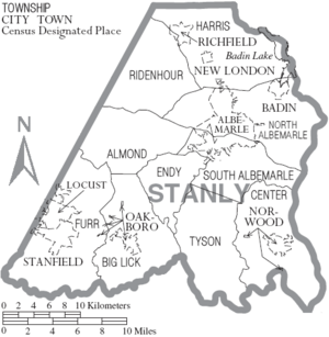
Towns and Communities
Cities
Towns
Townships
- Almond
- Big Lick
- Center
- Endy
- Furr
- Harris
- North Albemarle
- Ridenhour
- South Albemarle
- Tyson
Census-Designated Places
These are areas that are like towns but are not officially incorporated as cities or towns.
Other Small Communities
- Beetsville
- Big Lick
- Cottonville
- Endy
- Finger
- Frog Pond
- Lambert
- Palestine
- Palmerville
- Plyler
- Porter
- Ridgecrest
- Tuckertown
- Kingville
See also
 In Spanish: Condado de Stanly para niños
 | Kyle Baker |
 | Joseph Yoakum |
 | Laura Wheeler Waring |
 | Henry Ossawa Tanner |


