
Albemarle, North Carolina facts for kids
Quick facts for kids
Albemarle, North Carolina
|
||
|---|---|---|

Downtown Albemarle
|
||
|
||
| Motto(s):
"Water. Air. Land. Opportunity."
|
||

Location in the U.S. state of North Carolina
|
||

Albemarle, North Carolina
Location in North Carolina

Albemarle, North Carolina
Location in the United States

Albemarle, North Carolina
Location in North America
|
||
| Country | United States | |
| State | North Carolina | |
| County | Stanly | |
| Area | ||
| • Total | 17.83 sq mi (46.19 km2) | |
| • Land | 17.71 sq mi (45.86 km2) | |
| • Water | 0.13 sq mi (0.33 km2) | |
| Elevation | 545 ft (152 m) | |
| Population
(2020)
|
||
| • Total | 16,432 | |
| • Density | 928.05/sq mi (358.33/km2) | |
| Time zone | UTC-5 (EST) | |
| • Summer (DST) | UTC-4 (EDT) | |
| ZIP codes |
28001-28002
|
|
| Area codes | 704 | |
| FIPS code | 37-00680 | |
| GNIS feature ID | 2403073 | |

Albemarle is a city in North Carolina, United States. It is the main town, or county seat, of Stanly County. In 2020, about 16,432 people lived there.
Contents
History of Albemarle
Where Did the Name Albemarle Come From?
The name Albemarle comes from an old English family name. It was specifically named after General George Monck. He was the first Duke of Albemarle. He was also one of the first owners, called proprietors, of the Carolina colony. This colony included the area where Albemarle is today.
Early Days and Colonial Times
Long ago, nearly 10,000 years ago, small groups of hunter-gatherers and mound builders lived where Albemarle is now. They were people who hunted animals and gathered plants for food. They also built large mounds of earth.
In the mid-1700s, many European settlers moved to this area. Some came from Pennsylvania and New Jersey. They were looking for more freedom to practice their religion and have their own political ideas. Others came from Virginia and eastern North Carolina.
In the early colonial period, the Albemarle area was part of a larger region. This region was divided into smaller areas over time. Eventually, it became part of Montgomery County.
How Stanly County and Albemarle Were Formed
.jpg)


The first post office in the Albemarle area opened in 1826. It was known as Smith's Store back then. The area became an important place for trade. This was because two main roads crossed there. One road went from Fayetteville to Salisbury. The other connected Charlotte and Raleigh.
For many years, this region was part of Montgomery County. But in 1841, people living west of the Yadkin River wanted their own county. They asked the North Carolina government to create Stanly County. Their request was approved.
After the new county was formed, leaders needed to choose a main town, or county seat. They chose a spot near where the old roads crossed. A man named Nehemiah Hearne's family gave 51 acres of land for the new town. The town's leaders planned the streets and lots. They sold the first lots to help pay for public buildings. The first courthouse was built in 1842. The City of Albemarle officially became a city in 1857.
Albemarle's Economy Over Time
In its early days, Albemarle grew thanks to farming, especially cotton. People also traded goods in the area. There was even a short "gold rush" in the nearby Uwharrie Mountains. Later, making textiles (cloth and fabric) became very important. Many textile mills opened in Albemarle, like Efird Manufacturing Co. and Wiscasset Mill Company.
In 1891, the Yadkin Railroad started train service to Albemarle from Salisbury. Later, in 1911, the Winston-Salem Southbound Railway built its own line. This helped the growing textile business. Today, this railway still carries freight, but passenger trains stopped in 1933. An old train station has been fixed up and is now a popular farmer's market.
In 1923, the first paved highway, NC-24/27, was built from Albemarle to Charlotte. In 1950, Stanly County Memorial Hospital opened. The land for the hospital was given by Wiscassett Mills.
Albemarle got its first indoor shopping center in 1966. It was called Quenby Mall. Later, in 1993, this building was changed to hold government offices.
In 2024, a new type of digital money was created in Albemarle. This was part of a fundraiser to help a local restaurant, "Jay's Seafood," after it was damaged in a fire.
Saving Historic Places


Albemarle was recognized in 1993 for its efforts to preserve its historic downtown. Many old buildings in the downtown area have been restored. There's also a plan to create a greenway. This path will connect many of the city's parks and historic sites.
The Freeman-Marks House is thought to be the oldest house still standing in Albemarle. It was likely built in the 1820s. Other important historic places include the Opera House/Starnes Jewelers Building and several historic districts downtown. The Isaiah W. "Buck" Snuggs House is another old home. The Stanly County Museum in Albemarle helps people learn about and protect the area's history.
Many buildings and areas in Albemarle are listed on the National Register of Historic Places. This means they are important to history and should be protected. These include the Albemarle Graded School-Central Elementary School and the Downtown Albemarle Historic District.
Geography of Albemarle
Albemarle covers about 15.8 square miles (40.9 square kilometers). Most of this area is land, with a small part being water.
The city is located where two main roads meet: U.S. Route 52 and NC-24/27. It's in the Piedmont Region of North Carolina. The land here has rolling hills, forests with trees that lose their leaves, and small, fast-flowing streams. These streams flow into the Yadkin River/Pee Dee River system.
What the Land is Made Of
Albemarle is in an area called the Carolina Slate Belt. The rocks here are mostly meta-mudstone and meta-argillite. These are types of rock that have been changed by heat and pressure. You can also find meta-sandstone, meta-conglomerate, and meta-volcanic rock.
Albemarle's Climate
Albemarle has a humid subtropical climate. This means it has cool to mild winters and hot, humid summers.
| Climate data for Albemarle, North Carolina (1991-2020 normals, extremes 1911–present) | |||||||||||||
|---|---|---|---|---|---|---|---|---|---|---|---|---|---|
| Month | Jan | Feb | Mar | Apr | May | Jun | Jul | Aug | Sep | Oct | Nov | Dec | Year |
| Record high °F (°C) | 82 (28) |
84 (29) |
92 (33) |
95 (35) |
102 (39) |
106 (41) |
109 (43) |
107 (42) |
105 (41) |
102 (39) |
88 (31) |
81 (27) |
109 (43) |
| Mean daily maximum °F (°C) | 50.9 (10.5) |
54.7 (12.6) |
62.5 (16.9) |
71.5 (21.9) |
78.7 (25.9) |
85.5 (29.7) |
88.6 (31.4) |
87.2 (30.7) |
81.3 (27.4) |
72.6 (22.6) |
62.0 (16.7) |
53.8 (12.1) |
70.8 (21.5) |
| Mean daily minimum °F (°C) | 30.9 (−0.6) |
33.3 (0.7) |
40.4 (4.7) |
48.3 (9.1) |
57.3 (14.1) |
65.7 (18.7) |
69.2 (20.7) |
68.1 (20.1) |
61.5 (16.4) |
49.6 (9.8) |
39.6 (4.2) |
34.2 (1.2) |
49.8 (9.9) |
| Record low °F (°C) | −7 (−22) |
1 (−17) |
5 (−15) |
20 (−7) |
29 (−2) |
40 (4) |
47 (8) |
44 (7) |
33 (1) |
21 (−6) |
11 (−12) |
0 (−18) |
−7 (−22) |
| Average rainfall inches (mm) | 3.80 (97) |
2.96 (75) |
3.99 (101) |
3.74 (95) |
3.50 (89) |
4.74 (120) |
5.23 (133) |
4.85 (123) |
4.62 (117) |
3.59 (91) |
3.34 (85) |
3.92 (100) |
48.28 (1,226) |
| Average snowfall inches (cm) | 0.4 (1.0) |
0 (0) |
0.4 (1.0) |
0 (0) |
0 (0) |
0 (0) |
0 (0) |
0 (0) |
0 (0) |
0 (0) |
0 (0) |
0 (0) |
0.8 (2) |
| Source: NOAA | |||||||||||||
People of Albemarle
| Historical population | |||
|---|---|---|---|
| Census | Pop. | %± | |
| 1890 | 248 | — | |
| 1900 | 1,382 | 457.3% | |
| 1910 | 2,116 | 53.1% | |
| 1920 | 2,691 | 27.2% | |
| 1930 | 3,493 | 29.8% | |
| 1940 | 4,060 | 16.2% | |
| 1950 | 11,798 | 190.6% | |
| 1960 | 12,261 | 3.9% | |
| 1970 | 11,126 | −9.3% | |
| 1980 | 15,110 | 35.8% | |
| 1990 | 14,939 | −1.1% | |
| 2000 | 15,680 | 5.0% | |
| 2010 | 15,903 | 1.4% | |
| 2020 | 16,432 | 3.3% | |
| 2022 (est.) | 16,766 | 5.4% | |
| U.S. Decennial Census | |||
Population in 2020
| Race | Number | Percentage |
|---|---|---|
| White (not Hispanic) | 10,205 | 62.1% |
| Black or African American (not Hispanic) | 3,873 | 23.57% |
| Native American | 44 | 0.27% |
| Asian | 452 | 2.75% |
| Pacific Islander | 1 | 0.01% |
| Other/Mixed | 853 | 5.19% |
| Hispanic or Latino | 1,004 | 6.11% |
In 2020, there were 16,432 people living in Albemarle. There were 6,220 households and 4,108 families.
Population in 2010
In 2010, Albemarle had 15,489 people. There were 6,291 households and 4,158 families.
Most people were White (72.85%), followed by African American (20.50%). About 4.16% were Asian. People of Hispanic or Latino background made up 1.87% of the population.
About 30.6% of households had children under 18. The average household had 2.42 people. The average family had 3.02 people.
The median age in the city was 37 years old. About 26% of the population was under 18.
Parks and Fun Things to Do

Albemarle has a Parks and Recreation Department that started in 1963. It manages five parks in the city. There's also a soccer complex and a place for making pottery.
One of the newer places is City Lake, which opened in 2003. It's a 75-acre park with a 100-acre lake. Other parks include Rock Creek Park, Chuck Morehead Memorial Park, Roosevelt Ingram Memorial Park, and Don Montgomery Memorial Park.
Morrow Mountain State Park is a large state park just east of Albemarle. It's located on a high hill in the Uwharrie Mountains next to the Yadkin River. You can do many fun activities there. The park has a museum about nature and a restored old house from the 1800s.
Education in Albemarle

Students in Albemarle can attend:
- Albemarle High School
- Stanly Community College
Media and News
Albemarle has a local newspaper called the Stanly News and Press. It started in 1880. Another newspaper, The Weekly Post, focuses on local community events. You can also read The Charlotte Observer in Albemarle.
There are two local radio stations in Albemarle:
- WSPC at 1010 AM plays news and talk shows.
- WZKY at 1580 AM plays oldies music.
For television, people in Albemarle can watch stations from the Charlotte area. The local cable company also offers one station from Greensboro, WFMY-TV.
Famous People from Albemarle
- Denico Autry – A football player for the Houston Texans in the NFL. He went to Albemarle High School.
- W. Horace Carter – A journalist who won a special award called the Pulitzer Prize.
- Louis Cato – A musician who plays many instruments. He leads the band for The Late Show with Stephen Colbert.
- Willie Drye – A journalist and writer.
- Woody Durham – A radio announcer famous for calling games for the Carolina Tar Heels. He started his radio career at WZKY 1580 AM in Albemarle.
- Stuart Daniel Baker – Known as Unknown Hinson, he is a musician and voice actor.
- Danny Kepley – A former all-star football player in the Canadian Football League. He is in the Canadian Football Hall of Fame.
- T.A. McLendon – A football running back who holds several national high school records. He played at Albemarle High School.
- Monty Montgomery – A former Major League Baseball player.
- Kellie Pickler – A singer who was on American Idol in 2006. She is a country music artist and won Dancing with the Stars in 2013.
- Tommy Smith – A former Major League Baseball player.
- June Tyson – A musician and singer. She was the first female member of the band Sun Ra and his Arkestra.
- Rhett Lowder – A professional baseball player for the Cincinnati Reds organization. He was the 7th overall pick in the 2023 MLB Draft.
Images for kids
-
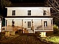
Historic Snuggs House
-
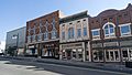
Looking down West Main Street, Albemarle Downtown Historic District
-
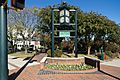
Courthouse Square Park
-
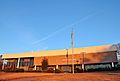
Patterson Building, Stanly Community College
See also
 In Spanish: Albemarle (Carolina del Norte) para niños
