Montgomery County, North Carolina facts for kids
Quick facts for kids
Montgomery County
|
|||
|---|---|---|---|

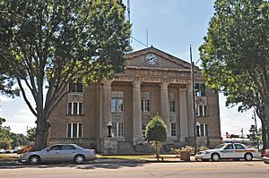
Montgomery County Courthouse
|
|||
|
|||
| Motto(s):
"The Golden Opportunity"
|
|||

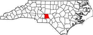
Location within the U.S. state of North Carolina
|
|||
 North Carolina's location within the U.S. |
|||
| Country | |||
| State | |||
| Founded | 1779 | ||
| Named for | Richard Montgomery | ||
| Seat | Troy | ||
| Largest community | Troy | ||
| Area | |||
| • Total | 501.54 sq mi (1,299.0 km2) | ||
| • Land | 491.54 sq mi (1,273.1 km2) | ||
| • Water | 10.00 sq mi (25.9 km2) 1.99% | ||
| Population
(2020)
|
|||
| • Total | 25,751 | ||
| • Estimate
(2023)
|
26,085 | ||
| • Density | 52.68/sq mi (20.34/km2) | ||
| Time zone | UTC−5 (Eastern) | ||
| • Summer (DST) | UTC−4 (EDT) | ||
| Congressional district | 8th | ||
Montgomery County is a rural county located in the southern Piedmont region of North Carolina. A "county" is a part of a state, like a district. In 2020, about 25,751 people lived here. The main town and government center, called the county seat, is Troy.
Contents
History of Montgomery County
Early Settlers and County Creation
The first people to live in the area that became Montgomery County were Keyauwee and Cheraw Native Americans. Later, the first European settlers arrived. They came from Germany and Scotland.
Montgomery County was officially created in 1779. It was formed from a part of Anson County. The county was named after Richard Montgomery. He was an important general in the American Revolutionary War. He died in 1775 while trying to capture Quebec City in Canada.
Establishing the County Seat
When the county was formed, leaders were told to find a central spot for a courthouse and prison. Many residents did not like the first location chosen. After some time, a courthouse was built in Henderson in 1794. This community was where the Yadkin and Uwharrie rivers met.
In 1816, the old courthouse was sold. A new one was built in a community called Laurenceville. In 1841, the western part of Montgomery County became Stanly County. Two years later, new leaders were chosen to move the courthouse again. They moved it to the center of Montgomery County. In 1844, Troy was established as the new county seat.
Modern Times and Challenges
The county's first paved roads were built in the 1920s. The Great Depression started in 1929. This was a very difficult time for the economy. It greatly affected farming and factories in the county. By 1933, about 30 out of every 100 people living there did not have jobs.
Geography of Montgomery County
Montgomery County covers about 501.54 square miles. Most of this area, about 491.54 square miles, is land. The remaining 10.00 square miles, or about 2%, is water.
Neighboring Counties
Montgomery County shares its borders with several other counties. These include Davidson, Moore, Richmond, Randolph, and Stanly counties.
Rivers and Natural Areas
Most of the county is part of the Yadkin–Pee Dee River Basin. This means that rivers and streams in this area flow into the Yadkin-Pee Dee River system. Smaller parts of the county are in the Cape Fear and Lumber River basins. A large part of the county is covered by the Uwharrie National Forest.
State and Local Protected Areas
- Pee Dee River Game Land (part)
- Roy J. Maness Nature Preserve
- Town Creek Indian Mound State Historic Site
- Uwharrie Game Land (part)
- Yadkin River Game Land (part)
Major Water Bodies
- Badin Lake
- Big Creek
- Big Mountain Creek
- Densons Creek
- Drowning Creek
- Great Pee Dee River
- Jackson Creek
- Lake Tillery
- Little River
- Rocky Creek
- Spencer Creek
- Tuckertown Reservoir
- Uwharrie River
- Yadkin River
Population and People
| Historical population | |||
|---|---|---|---|
| Census | Pop. | %± | |
| 1790 | 5,039 | — | |
| 1800 | 7,677 | 52.4% | |
| 1810 | 8,430 | 9.8% | |
| 1820 | 8,693 | 3.1% | |
| 1830 | 10,919 | 25.6% | |
| 1840 | 10,780 | −1.3% | |
| 1850 | 6,872 | −36.3% | |
| 1860 | 7,649 | 11.3% | |
| 1870 | 7,487 | −2.1% | |
| 1880 | 9,374 | 25.2% | |
| 1890 | 11,239 | 19.9% | |
| 1900 | 14,197 | 26.3% | |
| 1910 | 14,967 | 5.4% | |
| 1920 | 14,607 | −2.4% | |
| 1930 | 16,218 | 11.0% | |
| 1940 | 16,280 | 0.4% | |
| 1950 | 17,260 | 6.0% | |
| 1960 | 18,408 | 6.7% | |
| 1970 | 19,267 | 4.7% | |
| 1980 | 22,469 | 16.6% | |
| 1990 | 23,346 | 3.9% | |
| 2000 | 26,822 | 14.9% | |
| 2010 | 27,798 | 3.6% | |
| 2020 | 25,751 | −7.4% | |
| 2023 (est.) | 26,085 | −6.2% | |
| U.S. Decennial Census 1790–1960 1900–1990 1990–2000 2010 2020 |
|||
2020 Census Information
The 2020 census counted 25,751 people living in Montgomery County. There were 10,195 households, which are groups of people living together. There were also 6,788 families.
| Race | Number | Percentage |
|---|---|---|
| White (non-Hispanic) | 16,504 | 64.0% |
| Black or African American (non-Hispanic) | 4,192 | 16.28% |
| Native American | 76 | 0.3% |
| Asian | 391 | 1.52% |
| Pacific Islander | 2 | 0.01% |
| Other/Mixed | 662 | 2.57% |
| Hispanic or Latino | 3,924 | 15.24% |
Economy and Jobs
One of the largest lumber mills in the United States is located near Mt. Gilead. This is a Jordan Lumber & Supply facility. It plays a big role in the county's economy.
Transportation in Montgomery County
Roads and Highways
Interstate 73/Interstate 74 passes through the eastern part of Montgomery County. The main road that goes from east to west across the county is North Carolina Highway 27.
Major Highways
 US 220


 US 220 Alt.
 NC 24
NC 24
 NC 24 Bus. (business route)
 NC 27 Bus.
 NC 73
NC 73 NC 109
 NC 109 Bus. (Mount Gilead)
 NC 109 Bus. (Troy)
 NC 134
 NC 211
 NC 731
Rail and Air Travel
Freight train service is provided by the Aberdeen, Carolina and Western Railway. This railway has an east-to-west line through the county. It connects to bigger cities like Charlotte and Raleigh. Another line goes south to the Southern Pines/Pinehurst area. For corporate and private airplanes, there is the Montgomery County Airport. It is located in the eastern part of the county.
Education in Montgomery County
The public school system in Montgomery County offers several schools. There are five elementary schools: Star, Mt. Gilead, Candor, Page Street, and Green Ridge. There are also two middle schools: West Montgomery and East Montgomery.
For high school, there is Montgomery Central High. This school was formed in 2020 when East Montgomery High and West Montgomery High joined together. For education after high school, students can attend Montgomery Community College.
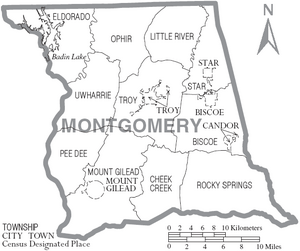
Communities in Montgomery County
Towns
- Biscoe
- Candor
- Mount Gilead
- Star
- Troy (This is the county seat and the largest community.)
Townships
- Biscoe
- Cheek Creek
- Eldorado
- Little River
- Mount Gilead
- Ophir
- Pee Dee
- Rocky Springs
- Star
- Troy
- Uwharrie
Unincorporated Communities
- Abner
- Black Ankle
- Blaine
- Chip
- Dry Creek
- Eldorado
- Emery
- Ether
- Harrisville
- Love Joy
- Okeewemee
- Ophir
- Pee Dee
- Pekin
- Steeds
- Thickety Creek
- Uwharrie
- Wadeville
- Windblow
Notable People
- Beulah Parson Davis (1896–1948), a fortune-telling witch.
- Henry F. Warner (1923–1944), a soldier in the United States Army. He received the Medal of Honor during World War II.
See also
 In Spanish: Condado de Montgomery (Carolina del Norte) para niños
 | Claudette Colvin |
 | Myrlie Evers-Williams |
 | Alberta Odell Jones |


