
Chatham County, Georgia facts for kids
Quick facts for kids
Chatham County
|
||
|---|---|---|

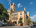
Chatham County Administrative and Legislative Center in Savannah
|
||
|
||

Location within the U.S. state of Georgia
|
||
 Georgia's location within the U.S. |
||
| Country | ||
| State | ||
| Founded | February 5, 1777 | |
| Named for | William Pitt, 1st Earl of Chatham | |
| Seat | Savannah | |
| Largest city | Savannah | |
| Area | ||
| • Total | 632 sq mi (1,640 km2) | |
| • Land | 426 sq mi (1,100 km2) | |
| • Water | 206 sq mi (530 km2) 32.6%% | |
| Population
(2020)
|
||
| • Total | 295,291 |
|
| • Density | 470/sq mi (180/km2) | |
| Time zone | UTC−5 (Eastern) | |
| • Summer (DST) | UTC−4 (EDT) | |
| Congressional district | 1st | |

Chatham County is a county in Georgia, located right on the Atlantic Ocean coast. Its main city, and where the county government is, is Savannah. Chatham County is one of Georgia's original counties. It was created on February 5, 1777. The county is named after William Pitt, 1st Earl of Chatham, a famous British leader.
In 2020, about 295,291 people lived in Chatham County. This was a good increase from the 2010 population. Chatham is the sixth largest county in Georgia by population. It is also the largest county in Georgia outside of the big Atlanta metropolitan area. Chatham County is the main part of the Savannah metropolitan area.
Contents
Geography
Chatham County covers a total area of about 632 square miles. A big part of this area, about 206 square miles (32.6%), is covered by water.
Chatham County is the northernmost of Georgia's counties that touch the Atlantic Ocean. The Savannah River forms its northeastern border. The Ogeechee River forms its southwestern border. Most of Chatham County is in the Ogeechee River basin. The northern part is in the Savannah River basin.
Major Roads
Many important roads run through Chatham County. These roads help people travel easily within the county and to other places.
 I-16 (Interstate 16)
 I-95 (Interstate 95)
 I-516 (Interstate 516)
 US 17
US 17 US 80
US 80 SR 17
SR 17 SR 21
SR 21 SR 21 Spur
 SR 25
SR 25 SR 26
SR 26 SR 26 Conn.
 SR 30
SR 30 SR 204
 SR 204 Spur (No longer used)
 SR 307
 SR 404 (This is another name for I-16)
 SR 404 Spur
 SR 405 (This is another name for I-95)
 SR 421 (This is another name for I-516)
 SR 565 (Savannah River Parkway)
Neighboring Counties
Chatham County shares its borders with several other counties:
- Jasper County, South Carolina – to the northeast
- Bryan County – to the west and southwest
- Liberty County - to the southeast
- Effingham County – to the northwest
Protected Natural Areas
Chatham County is home to important natural and historical sites:
- Fort Pulaski National Monument: A historic fort.
- Savannah National Wildlife Refuge (part): A place for wildlife.
- Wassaw National Wildlife Refuge: Another wildlife refuge.
Communities
Chatham County has many different towns and cities where people live.
Cities
- Bloomingdale
- Garden City
- Pooler
- Port Wentworth
- Savannah (This is the county seat)
- Tybee Island
Towns
Census-Designated Places
These are areas that are like towns but don't have their own local government.
Other Communities
These are smaller areas that are not officially cities or towns.
Population Information
The population of Chatham County has grown a lot over the years. Here's how it has changed:
| Historical population | |||
|---|---|---|---|
| Census | Pop. | %± | |
| 1790 | 10,769 | — | |
| 1800 | 12,946 | 20.2% | |
| 1810 | 13,540 | 4.6% | |
| 1820 | 14,737 | 8.8% | |
| 1830 | 14,127 | −4.1% | |
| 1840 | 18,801 | 33.1% | |
| 1850 | 23,901 | 27.1% | |
| 1860 | 31,043 | 29.9% | |
| 1870 | 41,279 | 33.0% | |
| 1880 | 45,023 | 9.1% | |
| 1890 | 57,740 | 28.2% | |
| 1900 | 71,239 | 23.4% | |
| 1910 | 79,690 | 11.9% | |
| 1920 | 100,032 | 25.5% | |
| 1930 | 105,431 | 5.4% | |
| 1940 | 117,970 | 11.9% | |
| 1950 | 151,481 | 28.4% | |
| 1960 | 188,299 | 24.3% | |
| 1970 | 187,767 | −0.3% | |
| 1980 | 202,226 | 7.7% | |
| 1990 | 216,935 | 7.3% | |
| 2000 | 232,048 | 7.0% | |
| 2010 | 265,128 | 14.3% | |
| 2020 | 295,291 | 11.4% | |
| 2023 (est.) | 303,655 | 14.5% | |
| U.S. Decennial Census 1790-1880 1890-1910 1920-1930 1930-1940 1940-1950 1960-1980 1980-2000 2010 2020 |
|||
Chatham County is a diverse place with people from many different backgrounds. The table below shows the mix of different groups living in the county over the years.
| Race / Ethnicity (NH = Non-Hispanic) | Pop 2000 | Pop 2010 | Pop 2020 | % 2000 | % 2010 | % 2020 |
|---|---|---|---|---|---|---|
| White alone (NH) | 125,802 | 133,492 | 139,433 | 54.21% | 50.35% | 47.22% |
| Black or African American alone (NH) | 93,463 | 105,274 | 108,011 | 40.28% | 39.71% | 36.58% |
| Native American or Alaska Native alone (NH) | 517 | 587 | 619 | 0.22% | 0.22% | 0.21% |
| Asian alone (NH) | 3,992 | 6,229 | 10,620 | 1.72% | 2.35% | 3.60% |
| Pacific Islander alone (NH) | 128 | 224 | 408 | 0.06% | 0.08% | 0.14% |
| Other race alone (NH) | 311 | 476 | 1,447 | 0.13% | 0.18% | 0.49% |
| Mixed race or Multiracial (NH) | 2,432 | 4,476 | 10,963 | 1.05% | 1.69% | 3.71% |
| Hispanic or Latino (any race) | 5,403 | 14,370 | 23,790 | 2.33% | 5.42% | 8.06% |
| Total | 232,048 | 265,128 | 295,291 | 100.00% | 100.00% | 100.00% |
In 2020, there were 295,291 people living in the county. These people lived in about 107,987 households, which included 65,889 families.
Education

Public schools in Chatham County are managed by Savannah-Chatham County Public Schools. This school district covers the entire county.
Libraries
The Live Oak Public Libraries system provides library services to Chatham County. It also serves two other Georgia counties: Effingham and Liberty. The system used to be called "Chatham Effingham Liberty Regional Library." In 2002, its name changed to Live Oak. This new name reflects the local area and how the libraries have grown.
The idea for a public library in Savannah started in the early 1900s. The Georgia Historical Society and the city of Savannah worked together to create the Savannah Public Library in 1903. This library became very important for the community. However, it's important to know that this library did not serve all citizens at first.
Images for kids
-
Chatham County Administrative and Legislative Center in Savannah
See also
 In Spanish: Condado de Chatham (Georgia) para niños
