Montgomery, Georgia facts for kids
Quick facts for kids
Montgomery, Georgia
|
|
|---|---|

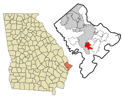
Location in Chatham County and the state of Georgia
|
|
| Country | United States |
| State | Georgia |
| County | Chatham |
| Area | |
| • Total | 6.10 sq mi (15.81 km2) |
| • Land | 5.21 sq mi (13.51 km2) |
| • Water | 0.89 sq mi (2.30 km2) |
| Elevation | 13 ft (4 m) |
| Population
(2020)
|
|
| • Total | 4,443 |
| • Density | 851.97/sq mi (328.95/km2) |
| Time zone | UTC-5 (Eastern (EST)) |
| • Summer (DST) | UTC-4 (EDT) |
| FIPS code | 13-52332 |
| GNIS feature ID | 0332411 |
Montgomery is a community in Chatham County, Georgia, United States. It is known as a census-designated place (CDP). This means it's an area that the government counts for statistics, but it doesn't have its own city government. Montgomery is a suburb of Savannah and is part of the larger Savannah metropolitan area. In 2020, about 4,443 people lived there.
History of Montgomery
Montgomery is thought to be where one of the first settlements in the Savannah area was located. This was even before General Oglethorpe received his land grant in 1733. Three British brothers named William, James, and Robert Montgomery started this settlement. They received a special permission, called a land grant, in 1677.
However, they couldn't keep their settlement going. The location wasn't good, and people got sick. Because of this, they lost their land grant. The brothers then moved to the Virginia Colony, which was already more established. Even though their settlement didn't last, the name "Montgomery" is still used in this part of Chatham County. You can find places like Old Montgomery Road, Montgomery Street, and Montgomery Cross Road.
Geography and Location
Montgomery is located in the southern part of Chatham County. Its exact location is 31°56′36″N 81°6′24″W / 31.94333°N 81.10667°W. It sits on a piece of land surrounded by rivers. The Vernon River is to the west, the Moon River is to the east, and the Burnside River is to the south. All these rivers are tidal, meaning their water levels change with the ocean's tides.
The northeast edge of Montgomery is next to Georgia SR 204 Spur. This road leads to Skidaway Island. Downtown Savannah is about 13 miles (21 km) (about 21 kilometers) north of the center of Montgomery.
The United States Census Bureau says that Montgomery covers a total area of 6.1 square miles (15.7 km2). Most of this area, 5.2 square miles (13.5 km2), is land. The rest, 0.85 square miles (2.2 km2) or about 13.94%, is water.
Population Changes
Montgomery was first counted as a census-designated place (CDP) in the 1990 U.S. Census. The population has changed a bit over the years:
| Historical population | |||
|---|---|---|---|
| Census | Pop. | %± | |
| 1990 | 4,327 | — | |
| 2000 | 4,134 | −4.5% | |
| 2010 | 4,523 | 9.4% | |
| 2020 | 4,443 | −1.8% | |
| U.S. Decennial Census | |||
As of the 2020 United States census, there were 4,443 people living in Montgomery. These people lived in 1,609 households, and 1,161 of these were families.
Notable People
- Henry McKenzie (died 1974) was a well-known person from Montgomery. He was a newspaper publisher, meaning he helped create and print newspapers. He was also a politician, which means he was involved in government and public affairs.
See also
 In Spanish: Montgomery (Georgia) para niños
 | Sharif Bey |
 | Hale Woodruff |
 | Richmond Barthé |
 | Purvis Young |

