
Bakers Creek (Cape Fear River tributary) facts for kids
Quick facts for kids Bakers Creek |
|
|---|---|


Location of Bakers Creek mouth
|
|
| Other name(s) | Tributary to Cape Fear River |
| Country | United States |
| State | North Carolina |
| County | Bladen |
| Physical characteristics | |
| Main source | Bear Ford Swamp divide Dublin, North Carolina 126 ft (38 m) 34°39′52″N 078°42′46″W / 34.66444°N 78.71278°W |
| River mouth | Cape Fear River about 1 mile south of Yorick, North Carolina 24 ft (7.3 m) 34°39′19″N 078°35′21″W / 34.65528°N 78.58917°W |
| Length | 4.81 mi (7.74 km) |
| Basin features | |
| Progression | southeast |
| River system | Cape Fear River |
| Basin size | 9.03 square miles (23.4 km2) |
| Tributaries |
|
| Bridges | McDaniel Lane, Lyon Landing Road, Rice Pond Road, Owen Hill Road |
Bakers Creek is a small stream, about 4.81 mi (7.74 km) long, located in Bladen County, North Carolina. It's like a smaller helper stream that flows into a bigger river. For Bakers Creek, its waters eventually join the famous Cape Fear River.
Contents
Where Bakers Creek Flows
Bakers Creek starts its journey near the town of Dublin, North Carolina. It begins in an area where the land divides water flow, known as the Bear Ford Swamp divide.
From there, the creek flows mostly towards the southeast. After its short trip, Bakers Creek meets and joins the Cape Fear River. This meeting point is about 1 mile southwest of a place called Yorick, North Carolina.
The Land Around Bakers Creek
The area that Bakers Creek drains is called its watershed. This watershed covers about 9.03 square miles (23.4 km2) of land. Think of it as all the land where rain falls and eventually flows into Bakers Creek.
This region gets a good amount of rain, about 49.1 inches each year. A significant part of the land around the creek, about 21%, is covered by forests. These forests help keep the water clean and provide homes for many plants and animals.
Bridges Over Bakers Creek
Even though Bakers Creek is a smaller stream, several roads cross over it. These bridges help people travel easily around the area. Some of the roads with bridges over Bakers Creek include:
- McDaniel Lane
- Lyon Landing Road
- Rice Pond Road
- Owen Hill Road
Images for kids
-
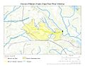
Course of Bakers Creek (Cape Fear River tributary)
-
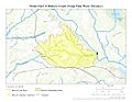
Watershed of Bakers Creek (Cape Fear River tributary)


