
Smith River (Virginia) facts for kids
Quick facts for kids Smith River |
|
|---|---|


|
|
| Physical characteristics | |
| Main source | 36°45′21″N 80°20′56″W / 36.7559687°N 80.3489478°W |
| River mouth | 36°28′50″N 79°45′04″W / 36.4806937°N 79.7511464°W |

The Smith River is a river that flows through the U.S. states of Virginia and North Carolina. It eventually joins the Dan River in Eden, North Carolina. This river has also been known by other names like Irvin River, Irvine River, and Smith's River.
The Smith River gets its water from Philpott Lake. It is a special type of stream called a "tailrace stream." This means its water flow is controlled by Philpott Dam. The dam helps manage the water for making electricity, keeping the water temperature right downstream, and making sure there's enough water for fun activities like boating. The river starts at Philpott Dam and flows for about 44.5 miles through Franklin County and Henry County in Virginia. Then, it crosses into Rockingham County, North Carolina and flows for another 5.25 miles before meeting the Dan River.
Contents
Discovering the Smith River's Past
Archaeologists have found clues that show people first visited the Smith River a very long time ago. These early visitors were hunter-gatherers. They came during the late PaleoIndian period (around 9,000-8,000 B.C.) and the Early Archaic period (8,000-6,000 B.C.).
Early Visitors and Settlements
From these very early times until about A.D. 1200, small groups of hunters would visit the Smith River Valley during different seasons. They came to hunt the many animals living near the river. Later, around A.D. 1250 to A.D. 1450, Native American groups from the Late Woodland period began to settle permanently along the river. These groups, who spoke a language called Siouan, built farming villages.
Archaeological finds show that these villages were often protected by wooden palisades, which were like tall fences. The people living there grew a lot of maize (corn). One of these villages, called the Philpott site, was home to the Sara Indians until the 1650s.

How the River Got Its Name
One of the first Europeans to see the Smith River was William Byrd II. He was leading a group in 1728 to map the border between Virginia and North Carolina. On October 18, 1728, Byrd named the river "the river Irvine." He did this to honor Alexander Irvine, who was a surveyor in his group and also a math professor at the College of William and Mary.
William Byrd wrote about the river in his book, The History of the Dividing Line. He described how they had to cross the river, which was difficult because of the rocky bottom. He said the river was "full and limpid" (clear) and made a "murmur" (soft sound) as it flowed over the rocks. He also noted that small boats could travel on the river, except for some larger waterfalls further downstream.
The name Irvine River was used in official land records as early as the 1730s. It also appeared on a map drawn by Edward Moseley in 1737. This name was common among colonial leaders in Virginia until the late 1700s. For example, it was on the important Fry-Jefferson map of 1755.
However, by 1743, people started using the name "Smith's River" in land records. Historians believe this name came from two important landowners from the 1740s, Gideon and Daniel Smith. For many years, both "Smith's River" and "Irvine River" were used. "Smith's River" was more of a local name, while "Irvine River" was used in official documents. But by the late 1800s, "Smith River" became the most common name, and "Irvine River" was no longer used.
Smith River's Role in Industry
In the late 1800s and early 1900s, the Smith River became very important for its water power. This power was used for lumber and textile (fabric) mills. At first, these mills made wooden ties for the new Norfolk and Western railroad. After the railroad was finished, some lumber mills started making wood furniture instead. A famous furniture company, Bassett Furniture, started in 1902 on its original mill site along the Smith River. It is still in business today!
Images for kids
-
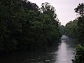
Evening view of the Smith River
-
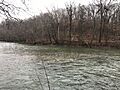
The Smith River in Eden, North Carolina
