
Motes Creek (Haw River tributary) facts for kids
Quick facts for kids Motes Creek |
|
|---|---|


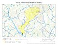
Location of Motes Creek mouth
|
|
| Other name(s) | Tributary to Haw River |
| Country | United States |
| State | North Carolina |
| County | Alamance |
| Physical characteristics | |
| Main source | divide between Motes Creek and Cane Creek about 4 miles northeast of Saxapahaw, North Carolina 640 ft (200 m) 35°59′48″N 079°17′13″W / 35.99667°N 79.28694°W |
| River mouth | Haw River Saxapahaw, North Carolina 413 ft (126 m) 35°56′34″N 079°18′56″W / 35.94278°N 79.31556°W |
| Length | 5.39 mi (8.67 km) |
| Basin features | |
| Progression | southwest |
| River system | Haw River |
| Basin size | 5.62 square miles (14.6 km2) |
| Tributaries |
|
| Waterbodies | unnamed waterbody |
| Bridges | Dodson Lane, NC 54, Salem Church Road, Saxapahaw Salem Church Road |
Motes Creek is a small stream, about 5.39 mi (8.67 km) long. It flows into the Haw River in Alamance County, North Carolina. This creek is an important part of the local water system.
Contents
Motes Creek: A North Carolina Waterway
Where Does Motes Creek Flow?
Motes Creek starts in Alamance County, North Carolina. Its source is about 4 miles northeast of a town called Saxapahaw, North Carolina. The creek then flows east. It eventually joins the larger Haw River right in Saxapahaw.
The Land Motes Creek Drains
Motes Creek helps drain an area of about 5.62 square miles (14.6 km2). This area is called its watershed. The watershed gets about 46.5 inches of rain each year. About 39% of the land in this watershed is covered by forests.
Images for kids
-
This map shows the path of Motes Creek in Alamance County, North Carolina.
-
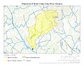
This map shows the area of land that Motes Creek drains.
.jpg)
.jpg)
