
Mountains-to-Sea Trail facts for kids
Quick facts for kids Mountains-to-Sea Trail |
|
|---|---|

Sunset view from Clingman's Dome, the western end of the trail
|
|
| Length | 1,175 mi (1,891 km) |
| Location | North Carolina, United States |
| Designation | National Recreation Trail North Carolina State Trail |
| Trailheads | Jockey's Ridge, Clingman's Dome |
| Use | Hiking |
| Elevation change | 6,684 ft (2,037 m) |
| Highest point | Mount Mitchell |
| Lowest point | Pamlico Sound |
| Difficulty | Moderate to Strenuous |
| Sights | Appalachian Mountains Sauratown Mountains Multiple rivers Outer Banks |
| Hazards | American alligator American black bear Biting flies Chiggers Diarrhea from water Dog attacks Limited water Mosquitos Poison ivy Severe weather Steep grades Tick-borne diseases Traffic collisions Venomous snakes Yellowjackets |
| Surface | Natural, sand, gravel, boardwalk, asphalt |
| Website | https://mountainstoseatrail.org/ |
The Mountains-to-Sea State Trail (MST) is a very long path for hiking and backpacking. It stretches across North Carolina from the Great Smoky Mountains all the way to the Outer Banks. Imagine walking from high mountains to sandy beaches!
The trail starts in the west at Clingman's Dome. Here, it connects with the famous Appalachian Trail. Its eastern end is at Jockey's Ridge State Park. This park has the tallest sand dune on the East Coast. The MST is like a main path that connects many other trails and beautiful natural spots across North Carolina. More than half of this amazing trail is already finished.
The Mountains-to-Sea State Park Trail became an official part of North Carolina's state park system on August 2, 2000. Since then, the trail has grown to include over 691 acres of land. This land is managed by local groups as nature parks. The trail is also part of the North Carolina State Trails System. As of January 2019, about 669 miles of the MST have been officially marked.
Some parts of the MST that follow the Blue Ridge Parkway were named a National Recreation Trail in 2005. This trail is special because it reaches the highest point of any long-distance trail in the eastern United States. It crosses Mount Mitchell at 6,684 feet high!
Contents
What Other Trails Does the MST Connect With?
The Mountains-to-Sea Trail uses parts of several other well-known trails. This helps hikers explore even more of North Carolina's beauty.
- The MST shares a few miles with the Appalachian Trail near its western start.
- It includes the Art Loeb Trail.
- The MST follows most of the Tanawha Trail.
- It also shares most of the Sauratown Trail. This is a special trail for both hikers and horseback riders. It connects two state parks and is the longest trail on private land in North Carolina.
- A newer part of the trail is the Haw River Trail. This section is still being reviewed.
- The trail follows paths in Eno River State Park. It then connects to the Falls Lake Trail.
- It follows the entire Neuse River Trail.
- The MST also uses the whole Neusiok Trail.
Camping Along the Trail
If you plan to camp on the Mountains-to-Sea Trail, it's important to know the rules. The trail goes through many different types of land. This means camping rules can change from one area to another. Always check the rules for where you plan to stay!
Camping in the Mountains
In the mountain section, especially in the Great Smoky Mountains National Park, you can camp at special campsites. You will need a permit to do this. Make sure to contact the park for permit and reservation details.
Camping along the Blue Ridge Parkway is usually not allowed. However, there are some official campgrounds you can use. These include Doughton Park, Julian Price Park, Linville Falls, Crabtree Meadows, and Mt. Pisgah. Sometimes, hikers can find campsites just outside the parkway boundaries in national forests. There is one special backpack site open in Julian Price Park.
Camping in the Piedmont and East
In the Piedmont section of North Carolina, camping is not allowed on the Sauratown Trail. This part of the trail is on land leased from private owners. You can find a list of nearby campgrounds and places to stay on the Sauratown Trails Association Website. There are also three private campgrounds close to the Sauratown Trail.
Inside North Carolina State Parks, you can only camp at marked campsites. Large parts of the Falls Lake State Recreation Area also do not allow camping.
It's very important not to camp illegally along the MST. If you are caught, you could face fines. Always follow the rules to keep the trail safe and open for everyone.
Special Park Lands Along the MST
The MST includes 691 acres of land that are part of the state park system. These areas are managed by local governments as nature parks.
Shallow Ford Natural Area
The Shallow Ford Natural Area is a 191-acre park in Alamance County. It sits along the Haw River. This area has trails built by volunteers, a few simple campsites, and a place to launch a canoe. It also has a picnic area. This natural area was added to help complete a section of the MST.
Richardson-Taylor Preserve
The Richardson-Taylor Preserve is a new 440-acre nature preserve. It was bought by Guilford County and the State of North Carolina. This preserve helps protect the Greensboro Watershed and provides a path for the MST. It connects the watershed trails to Haw River State Park. The preserve is managed by the Greensboro Parks & Recreation Department.
Clayton River Walk
A third piece of land is used for the Clayton River Walk in the Town of Clayton. This River Walk extends the Neuse River Trail into Johnston County. It is also part of the East Coast Greenway route. The northernmost part of this River Walk is owned by the state park system.
Places You Can See Along the Trail
The Mountains-to-Sea Trail goes through or near many interesting natural areas in North Carolina. Here are some of them, listed from west to east:
- Great Smoky Mountains National Park (Where the trail starts in the west)
- The Blue Ridge Parkway (The trail often follows this scenic road in the mountains.)
- Nantahala National Forest
- Middle Prong Wilderness
- Pisgah National Forest
- Mount Pisgah Recreation Area (Blue Ridge Parkway)
- Bent Creek Experimental Forest
- Craggy Gardens Recreation Area (Blue Ridge Parkway)
- Mount Mitchell State Park
- Lake James State Park (connected by a special path)
- Linville Gorge Wilderness
- Harper Creek Wilderness Study Area
- Lost Cove Wilderness Study Area
- Grandfather Mountain State Park
- Julian Price Memorial Park (Blue Ridge Parkway)
- Moses H. Cone Memorial Park (Blue Ridge Parkway)
- E. B. Jeffress Park (Blue Ridge Parkway)
- Doughton Park (Blue Ridge Parkway)
- Stone Mountain State Park
- Pilot Mountain State Park
- Hanging Rock State Park
- Greensboro Watershed
- Richardson-Taylor Preserve (Part of the State Park Trail)
- Haw River State Park
- Occoneechee Mountain State Natural Area
- Eno River State Park
- Falls Lake State Recreation Area
- Cliffs of the Neuse State Park
- Cherry Branch – Minnesott Ferry
- Croatan National Forest
- Cedar Island National Wildlife Refuge
- Cedar Island – Ocracoke Ferry
- Cape Hatteras National Seashore
- Hatteras – Ocracoke Ferry
- Pea Island National Wildlife Refuge
- Jockey's Ridge State Park (Where the trail ends in the east)
Photo gallery
These are images of or along the MST going from west to east:
-
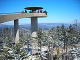
The western trail head, Clingman's Dome, on a snowy day.
-
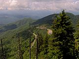
Waterrock Knob on the Blue Ridge Parkway.
-
Near the Blue Ridge Parkway in Pisgah National Forest, the MST shares a short stretch with the Art Loeb Trail
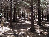
-
The MST follows the Camp Alice Trail through Mount Mitchell State Park.
-
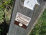
A MST sign post on the Blue Ridge Parkway.
-
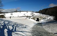
The MST crossing under a snowy Blue Ridge Parkway in Moses H. Cone Memorial Park.
-
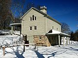
The carriage house at Moses H. Cone Memorial Park, which the trail passes by.
-
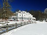
The trail switchbacks near Flat Top Manor at Moses H. Cone Memorial Park.
(The trail is not visible from this angle.) -
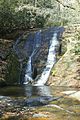
Widow Creek Falls in Stone Mountain State Park is a short spur walk off the trail.
-
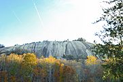
Stone Mountain of Stone Mountain State Park.
-
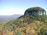
View from the Little Pinnacle at Pilot Mountain State Park. The MST follows the Sauratown Trail from the Pilot to the mountains seen in the distance.
-
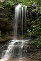
Lower drop of Window Falls at Hanging Rock State Park.
-
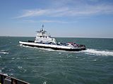
A ferry on the Hatteras – Ocracoke ferry route, which the MST utilizes.
-
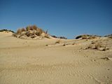
Jockey's Ridge State Park, the eastern trail head.


