
Waterrock Knob facts for kids
Quick facts for kids Waterrock Knob |
|
|---|---|

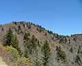
Waterrock Knob viewed from the Blue Ridge Parkway
|
|
| Highest point | |
| Elevation | 6,292 ft (1,918 m) |
| Prominence | 1,947 ft (593 m) |
| Geography | |
| Location | Haywood / Jackson Counties, North Carolina, U.S. |
| Parent range | Plott Balsams Blue Ridge Mountains |
| Topo map | USGS Sylva North |
| Climbing | |
| Easiest route | Hike |
Waterrock Knob is a tall mountain peak in the beautiful state of North Carolina, United States. It is the highest point in the Plott Balsams mountain range. This makes it one of the tallest mountains in the eastern part of the country.
This mountain is a popular spot for visitors and people who enjoy hiking. It's easy to reach from the famous Blue Ridge Parkway. There's a special visitors' center near the top. From there, a fun hiking trail leads right to the mountain's summit. The National Park Service helps take care of the trail and the visitors' center.
Contents
Waterrock Knob: A Mountain Adventure
What's in a Name?
Waterrock Knob got its interesting name from a spring located close to its peak. Long ago, hunters would stop at this spring to refill their water bottles. It was a handy and important spot for them!
Where is Waterrock Knob?
Waterrock Knob stands at an impressive height of 6,292 feet (1,918 m) (about 1,918 meters). It is the highest peak in the Plott Balsams mountains. This makes it one of the tallest mountains in the Eastern United States.
The mountain is located in the western part of North Carolina. It sits right on the border between Haywood and Jackson counties. The very top of the mountain is inside the Blue Ridge Parkway area. The town of Cherokee is about 10 miles (16 km) to the west. Another mountain, Richland Balsam, is about 10 miles (16 km) to the southeast.
Hiking to the Top
You can start your hike to the summit of Waterrock Knob from the Waterrock Knob Visitor Center. This center is found at milepost 451.2 on the Blue Ridge Parkway. The hiking trail is about 0.6 miles (0.97 km) long.
It climbs over 400 feet (120 m) (about 122 meters) from the parking lot. The first part of the trail is even paved, making it easier to start your adventure!
Images for kids
-
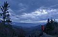
From the visitor center parking lot
-
Taken from the summit of Waterrock Knob
-
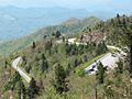
View of the Waterrock Knob parking lot and the Blue Ridge Parkway from the summit of Waterrock Knob
-
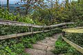
Waterrock Knob Trail


See also
