Plott Balsams facts for kids
Quick facts for kids Plott Balsams |
|
|---|---|

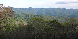
The Plott Balsams viewed from the Blue Ridge Parkway
|
|
| Highest point | |
| Peak | Waterrock Knob |
| Elevation | 6,292 ft (1,918 m) |
| Geography | |
| Country | United States |
| State | North Carolina |
| Range coordinates | 35°26′53″N 83°09′29″W / 35.4481567°N 83.1579218°W |
| Parent range | Blue Ridge Mountains |
| Borders on | Great Smoky Mountains Great Balsam Mountains |
The Plott Balsams are a beautiful mountain range in western North Carolina, in the southeastern United States. These mountains are part of the larger Appalachian Mountains, specifically the Blue Ridge Mountains. The Plott Balsams stretch from the town of Sylva in the southwest to Maggie Valley in the northeast.
To the north, the Plott Balsams are next to the famous Great Smoky Mountains. To the south, they border the Great Balsam Mountains. This mountain range is located in parts of Jackson County and Haywood County.
Contents
Tallest Peaks
The Plott Balsams are home to several tall mountains.
Waterrock Knob
Waterrock Knob is the highest mountain in the Plott Balsam Range. It stands at about 6,292 feet (1,918 m) tall. You can visit an overlook and a park service station near its top.
Other High Mountains
Four other mountains in this range are also over 6,000 feet high. These include:
- Mount Lyn Lowry (about 6,240 feet (1,900 m))
- Browning Knob (about 6,240 feet (1,900 m))
- Plott Balsam Mountain (about 6,088 feet (1,856 m))
- Yellow Face (about 6,032 feet (1,839 m))
Other important mountains include the Pinnacle, which looks over the Sylva area. There is also Blackrock Mountain (about 5,810 feet (1,770 m)) and Campbell Lick (about 5,875 feet (1,791 m)), which overlooks Maggie Valley.
Exploring the Plott Balsams
There are many ways to explore and enjoy the Plott Balsams.
Blue Ridge Parkway
The famous Blue Ridge Parkway winds through the highest parts of the Plott Balsam Range. This scenic road connects Soco Gap and Balsam Gap. It offers amazing views of the mountains and valleys.
Natural Areas
A large part of the south side of the Plott Balsam Range is protected by the Nantahala National Forest. This is a special area where nature is preserved. The Qualla Boundary is a reservation for the Eastern Band of Cherokee Indians. It includes parts of the mountains in the northwest, along Soco Creek. The town of Sylva also has a park along Fisher Creek in the southeast part of the range.
Lyn Lowry Memorial
On top of Mount Lyn Lowry, there is a special memorial. It honors Lyn Lowry, who passed away in 1962. The memorial includes a 60 feet (18 m) cross that lights up at night. You can see this cross from many miles away in the nearby towns.
Unique Forests
The higher parts of the Plott Balsams are covered by a special type of forest. It is called a Southern Appalachian spruce-fir forest. These forests are home to unique plants and animals.
Who Are the Plott Balsams Named After?
The Plott Balsams are named after the Plott family. An ancestor of this family, George Plott, came to North Carolina from Germany in the late 1700s. The Plott Hound, a special breed of hunting dog, is also named after this family.
 | Victor J. Glover |
 | Yvonne Cagle |
 | Jeanette Epps |
 | Bernard A. Harris Jr. |

