
Marys Creek (Haw River tributary) facts for kids
Quick facts for kids Marys Creek |
|
|---|---|


Location of Marys Creek mouth
|
|
| Other name(s) | Tributary to Haw River |
| Country | United States |
| State | North Carolina |
| County | Alamance |
| Physical characteristics | |
| Main source | divide between Marys Creek and Varnals Creek about 5 miles southeast of Rock Creek, North Carolina on the west side of Bass Mountain 735 ft (224 m) 35°56′27″N 079°24′06″W / 35.94083°N 79.40167°W |
| River mouth | Haw River about 3 miles southeast of Saxapahaw, North Carolina 407 ft (124 m) 35°55′28″N 079°17′56″W / 35.92444°N 79.29889°W |
| Length | 9.74 mi (15.68 km) |
| Basin features | |
| Progression | east |
| River system | Haw River |
| Basin size | 12.51 square miles (32.4 km2) |
| Tributaries |
|
| Bridges | Thompson Mill Road, Snow Camp Road, Jewell Road, Lindley Mill Road, Stockland Road, NC 87, Whitney Road |
Marys Creek is a small river, or creek, located in Alamance County, North Carolina. It flows for about 9.74 miles (15.68 km) before joining the larger Haw River. It's an important part of the local water system.
Where Marys Creek Flows
Marys Creek begins on the western side of Bass Mountain. This is about 5 miles southeast of a place called Rock Creek in Alamance County, North Carolina. From there, the creek flows generally towards the east.
Its journey ends when it meets the Haw River. This meeting point is about 3 miles southeast of Saxapahaw, North Carolina. The creek drops from an elevation of about 735 feet (224 meters) at its start to about 407 feet (124 meters) where it joins the Haw River.
The Marys Creek Watershed
A watershed is like a big bowl that collects all the rain and snowmelt in an area, and then drains it into a specific river or creek. The Marys Creek watershed covers an area of about 12.51 square miles (32.4 square kilometers).
This area gets a good amount of rain each year, around 46.6 inches (118 cm). A large part of the watershed, about 44%, is covered by forests. These forests help keep the water clean by filtering out pollutants and slowing down runoff.
Images for kids
-
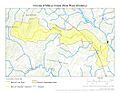
This map shows the path of Marys Creek in Alamance County, North Carolina.
-
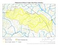
This map highlights the watershed area that drains into Marys Creek.
.jpg)
.jpg)
