McLeansville, North Carolina facts for kids
Quick facts for kids
McLeansville, North Carolina
|
|
|---|---|

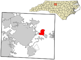
Where McLeansville is located in Guilford County and North Carolina
|
|
| Country | United States |
| State | North Carolina |
| County | Guilford |
| Named for | The McLean family |
| Area | |
| • Total | 6.21 sq mi (16.08 km2) |
| • Land | 6.13 sq mi (15.89 km2) |
| • Water | 0.07 sq mi (0.19 km2) |
| Elevation | 742 ft (226 m) |
| Population
(2020)
|
|
| • Total | 1,113 |
| • Density | 181.45/sq mi (70.06/km2) |
| Time zone | UTC-5 (Eastern (EST)) |
| • Summer (DST) | UTC-4 (EDT) |
| ZIP code |
27301
|
| Area code(s) | 336 |
| FIPS code | 37-40460 |
| GNIS feature ID | 2403270 |
McLeansville is a small community in Guilford County, North Carolina, United States. It's known as an unincorporated community, which means it doesn't have its own local government like a city or town. It's also a census-designated place (CDP), which is an area the U.S. Census Bureau defines for gathering population data. In 2010, about 1,021 people lived there.
Contents
Where is McLeansville?
McLeansville is located in the eastern part of Guilford County. To its west, you'll find the city of Greensboro. There's even a small part of Greensboro completely surrounded by McLeansville.
The center of McLeansville is about 9 miles (14 km) east of Greensboro. It's very close to US 70, also known as Burlington Road.
According to the United States Census Bureau, McLeansville covers a total area of about 6.2 square miles (16.2 square kilometers). Most of this area is land, with only a small part (about 0.07 square miles or 0.2 square kilometers) being water. South Buffalo Creek forms the western border of the community. This creek flows north into Buffalo Creek, which is part of a larger river system that eventually leads to the Cape Fear River.
Life in McLeansville
McLeansville has a grocery store, a post office, and several small businesses. You'll also find a few churches here. US 70 is a main road that connects McLeansville to nearby communities. These include Greensboro, Sedalia, Gibsonville, Whitsett, and Burlington.
Interstate 785 also goes through a small part of McLeansville. This highway connects the community north to US 29. McLeansville is also home to a large Publix Supermarket distribution center. This big building, finished in 2022, helps deliver groceries to stores. It's located right along US 70.
Areas around McLeansville, especially to the north, have rolling farmlands and wooded areas. You'll also see suburban homes and some shopping centers with grocery stores. The northern edge of McLeansville can be reached from Greensboro using US 29 and Hicone Road (Exit 136). In this area, you can find Northeast Guilford Middle and High Schools. There's also Boldmoon Preserve, a park with nature trails and signs about the local environment. It has frontage along Reedy Fork Creek.
Who Lives in McLeansville?
The population of McLeansville has changed over the years:
- 1980: 1,176 people
- 1990: 1,154 people
- 2000: 1,080 people
- 2010: 1,021 people
- 2020: 1,113 people
In 2000, there were 1,080 people living in McLeansville. Most of the people were White (94.54%). There were also African American (2.96%), Native American (0.37%), and Asian (0.09%) residents. About 1.85% of the population was Hispanic or Latino.
Many households (32.8%) had children under 18 living with them. Most households (59.7%) were married couples. The average household had about 2.46 people, and the average family had about 2.84 people.
The population was spread out by age. About 24.2% were under 18 years old. The median age was 40 years. This means half the people were younger than 40 and half were older.
Famous People from McLeansville
Some well-known people have connections to McLeansville:
- Daughtry - A popular rock band.
- Chris Daughtry - The lead singer of the band Daughtry, who was also a contestant on American Idol.
- Brandon Jones - An actor and musician.
See also
In Spanish: McLeansville (Carolina del Norte) para niños
 | Stephanie Wilson |
 | Charles Bolden |
 | Ronald McNair |
 | Frederick D. Gregory |

