
Mount Ulla Township, Rowan County, North Carolina facts for kids
Quick facts for kids
Mount Ulla
|
||
|---|---|---|
|
Township
|
||
|
||
| Motto(s):
Faith. Family. Farms
|
||

Location of Mount Ulla Township in Rowan County, N.C.
|
||

Mount Ulla
Location in the United States
|
||
| Country | United States | |
| State | North Carolina | |
| County | Rowan | |
| Settled | 1740s | |
| Named for | Ulaid | |
| Time zone | Eastern (EST) (UTC-5) | |
| ZIP code |
28125
|
|
| Area code(s) | 704, 980 | |
| GNIS feature ID | 990591, 1027149 | |

Mount Ulla Township is one of fourteen townships in Rowan County, North Carolina, United States. It is currently the smallest township in Rowan County by population.
Contents
Exploring Mount Ulla's Geography
Mount Ulla can mean different things. It might refer to the small, unnamed community. It could also mean the larger Mount Ulla Township, which was created in 1868. Sometimes, it refers to the area that shares the Mount Ulla zip code.
The Mount Ulla Township is an older administrative area. It is used for voting, taxes, and census counts. It includes smaller communities like Mount Ulla itself and part of Bear Poplar. This township was formed after the American Civil War in 1868. Before that, areas were called "Captain's Districts."
The Mount Ulla zip code area is different from the township. It stretches into other counties and townships. This means some historic communities are now considered part of the larger Mount Ulla area.
Where is Mount Ulla Located?
Mount Ulla Township is in the Piedmont region of western Rowan County, North Carolina. Its borders are marked by natural and man-made features. The northern border is near Knox Road and Beaverdam Creek. The eastern border follows North Carolina Highway 801 and other roads. The southern border follows North Carolina Highway 150. The western border is the line between Iredell and Rowan counties. Mount Ulla Township covers about 28.52 square miles (73.87 square kilometers).
Mount Ulla's Landscape and Land
The land in Mount Ulla is typical of the Piedmont plateau. It has rolling hills that reach up to 800 feet (250 meters) above sea level. Many springs feed into creeks like Beaverdam and Sills creeks. These creeks flow into the South Yadkin River.
Mount Ulla is in the Charlotte Belt of the Piedmont Plateau. Its geology includes old rock formations from the Paleozoic era. These rocks are granite, quartz, and diorite. The soils are mostly yellowish-red sandy clay and dark brown clay.
Mount Ulla's Climate and Weather
Mount Ulla has a temperate humid subtropical climate. This means it has four clear seasons. The area is in Plant Hardiness Zone 7b.
| Climate data for Mount Ulla, N.C. (1983-2018) | |||||||||||||
|---|---|---|---|---|---|---|---|---|---|---|---|---|---|
| Month | Jan | Feb | Mar | Apr | May | Jun | Jul | Aug | Sep | Oct | Nov | Dec | Year |
| Mean daily maximum °F (°C) | 49 (9) |
54 (12) |
61 (16) |
70 (21) |
78 (26) |
85 (29) |
86 (30) |
87 (31) |
81 (27) |
69 (21) |
60 (16) |
51 (11) |
69 (21) |
| Mean daily minimum °F (°C) | 26 (−3) |
30 (−1) |
36 (2) |
45 (7) |
55 (13) |
64 (18) |
65 (18) |
66 (19) |
59 (15) |
44 (7) |
35 (2) |
28 (−2) |
46 (8) |
| Average precipitation inches (mm) | 3.42 (87) |
3.17 (81) |
4.05 (103) |
3.78 (96) |
3.56 (90) |
3.98 (101) |
3.37 (86) |
3.99 (101) |
3.79 (96) |
3.26 (83) |
3.21 (82) |
3.33 (85) |
42.91 (1,091) |
| Source: Rowan Research Station | |||||||||||||
Plants of Mount Ulla
Mount Ulla is a farming community with many fields and pastures. Farming has changed the native plant life. Some foreign plants have been introduced and have become invasive. In the 1750s, the area was described as a "vast prairie" with lots of grass and few shrubs.
Native Plants
The natural forests here once had red, white, and post oak trees. Other native trees included shortleaf pine, hickory, poplar, and elm. Common native flowers include common blue violet and passion flower.
Farm and Garden Plants
Farming crops have changed over time. In the early 1900s, farmers grew cotton and tobacco. Today, Mount Ulla farmers grow corn, barley, wheat, soy, and sorghum.
Weed Plants
Weeds in Mount Ulla include non-native plants that spread easily. Some common pasture weeds from Europe are Canada thistle and dandelion. Invasive grasses include crabgrass and Bermuda grass. Invasive vines like kudzu and Japanese honeysuckle are also found.
Mount Ulla's Past: A Look at History
How Mount Ulla Got Its Name
Mount Ulla might be named after a village in Ireland called Oola. Another idea is that Rev. Andrew Y. Lockridge named the community in 1830. He was a big reader, so some think the name came from a book. There's also a new idea that it was named after Ulaid, an old kingdom in Ireland. This was the homeland of many early settlers.
The Mount Ulla Post Office started on April 22, 1843. It was first called Wood Grove Post Office.
Mount Ulla's Emblem
In December 2019, the Mount Ulla Historic Preservation Society showed a new sign. It honors the history of Mount Ulla. A Ukrainian designer named Nazar Burega created it. The emblem has symbols that honor the Scots-Irish Presbyterians and German Lutherans. These groups settled the area in the mid-1700s.
Early Settlements and Colonization
Before Europeans arrived, Native Americans lived in western Rowan County, where Mount Ulla is now. In 1567, a Spanish explorer named Juan Pardo visited a Native American village nearby. Later, war and disease caused the native people to disappear from the area.
The Carolina Charters
In 1629, King Charles I of England gave land in the New World to Sir Robert Heath. This land was called Province of Carolana. Plans to settle it didn't work out.
In 1663, King Charles II of England gave a new charter for a large territory to eight English noblemen. They were called Lords Proprietor. They had the power to start colonies and create laws. However, settling the Province of Carolina was hard. The Proprietors didn't visit the colony and faced many problems. In 1712, the Carolina colony split into North and South Carolina.
The Granville District
By 1729, most of North Carolina became a royal colony. But one Lord Proprietor, John Carteret, 2nd Earl Granville, kept his land rights. His share became known as the Granville District. This area was described as fertile and well-watered. Early settlers often built homes near creeks with fresh springs. Withrow Creek and Sills Creek in Mount Ulla are named after these early pioneers.
The Irish Settlement
The first recorded settlement in Mount Ulla was called "The Irish Settlement" around 1747-1749. Settlers built homes near creeks like Beaverdam and Sills Creeks. By 1750, there were enough people to form a new area called Anson County. In 1753, residents asked to form Rowan County, where Mount Ulla is today.
Many settlers in Mount Ulla were Scotch-Irish. These were Scottish people who had moved to Ireland and then to America. They traveled down the Great Wagon Road from Pennsylvania and Virginia. German settlers, also known as Pennsylvania Dutch, came too.
The Revolutionary Era
In 1774, people from Rowan County met in Salisbury. They created the Rowan Resolves. These resolutions stated that they were loyal to the King but opposed taxes without their consent. They believed this was unfair and made the colonies like slaves. They supported the people of Boston and called for unity among all colonies. They also called for a boycott of British goods. Some landowners from the Mount Ulla area, like George Cathy and Samuel Young, signed these resolves.
Records show that some people in this area owned enslaved people. For example, Abel Cowan owned 36 enslaved people in 1840. In the summer of 1868, political groups formed in Mount Ulla to deal with changes after the Civil War.
People of Mount Ulla
Population Details
| Historical population | ||
|---|---|---|
| Year | Pop. | ±% |
| 1870 | 1,720 | — |
| 1880 | 1,803 | +4.8% |
| 1890 | 1,389 | −23.0% |
| 1900 | 1,109 | −20.2% |
| 1910 | 1,237 | +11.5% |
| 1920 | 1,282 | +3.6% |
| 1930 | 1,389 | +8.3% |
| 1940 | 1,381 | −0.6% |
| 1950 | 1,112 | −19.5% |
| 1960 | 1,164 | +4.7% |
| 1970 | 1,214 | +4.3% |
| 1980 | 1,038 | −14.5% |
| 1990 | 1,116 | +7.5% |
| 2000 | 1,397 | +25.2% |
| 2010 (est.) | 2,525 | +80.7% |
In 2010, about 2,525 people lived in the Mount Ulla zip code area. About 25.5% of residents were ages 0–19. People over 65 made up 14.9% of the population. The average age was around 42 years old. About 51% of the population was male and 49% female. Nearly 63% of homes were husband and wife families.
Most residents (almost 96%) are White. About 2% are Black, and almost 2% are Hispanic/Latino. Eighty percent of residents have finished high school. Fifteen percent have a bachelor's degree or higher.
Language and Dialect
Mount Ulla residents speak a rural dialect of Southern American English. This dialect was influenced by the Scots-Irish settlers. Because people lived on isolated farms, there are small differences in how people speak. You might hear phrases like "over yonder." Some words might sound different, like "feller" instead of "fellow."
Religion and Churches
Most Mount Ulla residents are Protestant Christians. Several churches have served the community for many years:
- Back Creek Presbyterian Church (founded 1805)
- Centenary Methodist Church (established 1884)
- Ebenezer Church of Mt. Ulla (established 1853)
- Mount Tabor Presbyterian Church (founded 1867)
- Mount Zion Missionary Baptist Church (established 1853)
- St. Luke's Evangelical Lutheran Church (founded 1869)
- Thyatira Presbyterian Church (established before 1750)
How Mount Ulla is Governed
Mount Ulla does not have its own local government. It is governed at the county level by Rowan County.
Elections and Voting
Mount Ulla Township is a voting area called Mt.Ulla voting precinct 24. The polling place is at the West Rowan Fire Department. It is part of North Carolina Congressional district 13.
Schools in Mount Ulla
Since the 1960s, Mount Ulla has been served by Mount Ulla Elementary and West Rowan High School. These schools are part of the Rowan-Salisbury School System. Mount Ulla Elementary and West Rowan High School are located within the community. West Rowan Middle School is nearby but has a Salisbury address.
Historically, schools like Pine Grove School and Knox School were in the township. In early times, churches often ran schools. Rev. Andrew Lockridge, a pastor, taught a classical school. He also helped start Davidson College. Public schools began in the 1850s. Back Creek Academy was a private school operating in 1868.
German Lutherans started a school in 1872 at St. Luke's Lutheran Church. This school served the community until 1897. Public schools in the area improved over time. Mount Ulla Elementary School was accredited in 1937, and Mount Ulla High School in 1927. Schools became integrated in 1961.
Fire Departments and Safety
As Mount Ulla grew, the need for fire protection increased. In 1953, the first volunteer fire department opened. In 2001, the Mount Ulla-Bear Poplar Volunteer Fire Department joined with Centenary VFD. They formed the West Rowan Volunteer Fire Department. It has four fire stations covering 49 square miles. They serve about 3,000 people.
The West Rowan Fire Department is a volunteer group. It is funded by fire taxes. They respond to many calls, including medical emergencies. Firefighters are trained to help with medical emergencies when EMS is called.
Getting Around Mount Ulla
 NC 150
 NC 801
Miller Air Park is a private airport in the area.
In 1898, a railroad line connected Winston-Salem to Charlotte, passing through Mount Ulla. This line transported goods like furniture and tobacco. Passenger trains also stopped in Mount Ulla until the 1960s. Today, Norfolk Southern operates a freight line through Mount Ulla.
Mount Ulla's Economy
Mount Ulla has always been a farming community and still is today. Many notable farms and farm stores are in the area:
- Back Creek Farm
- Bear Poplar Farm (also a solar energy farm)
- Brown Farm (established 1835)
- Evans Family Farm
- Patterson Farm Market & Tours
- Owen Plantation
- Webster Family Farm (a flower and llama farm protected by The LandTrust for Central North Carolina)
- West Rowan Farm, Home & Garden
There are also plans to build a solar farm in Mount Ulla.
Culture and Community Life
Historic Places and Communities
Modern Mount Ulla includes many smaller historic communities. These show how local communities grew when travel was harder. Some communities fully or partly in Mount Ulla are:
- Bear Poplar
- Centenary
- Mazeppa
- Millbridge
- Miranda
- Mount Ulla
The Mill Bridge Scenic Byway, a special road for sightseeing, goes through a large part of Mount Ulla.
The Lazy 5 Ranch is a drive-through zoo in Mount Ulla. It opened in 1993 and is home to 750 animals from six continents.
Historic Buildings
Mount Ulla has many important historic buildings. Some are listed on the National Register of Historic Places:
- Back Creek Presbyterian Church and Cemetery
- Hall Family House
- Kerr Mill
- Knox Chapel Methodist Church
- Rankin-Sherrill House
- Wood Grove (a historic plantation)
Other historic properties include:
- Dr. George Alexander Brown House (built 1912)
- Hart's Post Office and Hart House (built 1880s)
- Lockridge-Goodman House (built 1830s by Rev. Andrew Y. Lockridge, who named Mount Ulla)
- St. Luke's Lutheran Church
Protecting Mount Ulla's Heritage
People in Mount Ulla work to preserve the community's history and farming traditions. Several farms, like Hoffner Brothers Dairy Farm, are protected by the Three Rivers Land Trust.
Tower Controversy (2005–2014)
In 2005, a company wanted to put a radio tower in Mount Ulla. Citizens formed the Mount Ulla Historic Preservation Society (MUHPS) in 2006. They wanted to protect the rural landscape and farming. The MUHPS and Miller Air Park Association stopped the tower. They argued it would be dangerous for local planes and ruin the view. This fight lasted from 2005 to 2014.
Dollar General Opposition
In March 2019, residents learned that Dollar General wanted to build a store in the community. This would change the land zoning from rural farming to commercial. About 150 citizens attended a meeting to show their strong opposition. A month later, the Mount Ulla Historic Preservation Society learned that the contract for the store was canceled. The landowner said the friendly people of Mount Ulla helped him decide to void the contract.
Community Clubs and Groups
Mount Ulla has several active civic clubs and organizations:
- John Knox Chapter, Daughters of the American Revolution
- Millbridge Ruritan Club
- Mount Ulla Historic Preservation Society
- Mount Ulla Lions Club
- West Rowan Future Farmers of America
Art in Mount Ulla
Barn Quilt Trail

In 2014-15, Adele Goodman started a Barn Quilt Trail in Mount Ulla. Barn quilts are large painted quilt patterns on barns. In July 2019, residents installed the largest community barn quilt in the United States. It is 500 square feet and is on a building in Bear Poplar. In November 2019, Elsie Bennett and Adele Goodman published a book about the stories behind the barn quilt squares.
Mount Ulla in Popular Culture
Mount Ulla was a filming location for Banshee. This was an American action TV series.
Notable People from Mount Ulla
Many interesting people have lived in or were born near Mount Ulla:
- Thomas Cowan, a Captain in the American Revolutionary War.
- Thomas Gillespie, a leader during the American Revolution and great-grandfather of President James K. Polk.
- Samuel Eusebius McCorkle, a pioneer preacher and teacher. He helped establish the University of North Carolina at Chapel Hill.
- Robert Hall “Hall” Steele, a Rowan County official who worked to protect farmland and history.
- Daniel and Will Thrailkill, award-winning bluegrass and jazz musicians.
- Natalie Wilson, a breastfeeding advocate and researcher. She helped start La Leche League in the former USSR.
- Margaret Ella Wilson Thomas, a gardener known for growing irises. An iris was named "Margaret Wilson Thomas" in her honor.
- Ashton White, the first woman to win first place in a national masonry competition.
Nearby Townships
Mount Ulla Township is next to these other townships:
- Atwell – to the south
- Barringer Township, Iredell County – to the southwest
- Chambersburg Township, Iredell County – to the northwest
- Cleveland – to the north
- Steele – to the east
 |
Chambersburg Township, Iredell County | Cleveland Township | |
|
| Steele Township | ||||
| Barringer Township, Iredell County | Atwell Township |
Images for kids
-
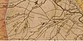
Area of Rowan County in 1833 where Mount Ulla township was created in 1868.
-
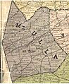
1903 Map of homes, churches, and schools in Mount Ulla Township


See also
 In Spanish: Municipio de Mount Ulla para niños
