Davie County, North Carolina facts for kids
Quick facts for kids
Davie County
|
|||||
|---|---|---|---|---|---|

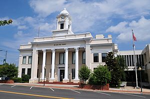
Davie County Courthouse
|
|||||
|
|||||
| Motto(s):
"You Belong Here"
|
|||||

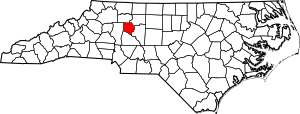
Location within the U.S. state of North Carolina
|
|||||
 North Carolina's location within the U.S. |
|||||
| Country | |||||
| State | |||||
| Founded | 1836 | ||||
| Named for | William R. Davie | ||||
| Seat | Mocksville | ||||
| Largest community | Mocksville | ||||
| Area | |||||
| • Total | 266.60 sq mi (690.5 km2) | ||||
| • Land | 263.70 sq mi (683.0 km2) | ||||
| • Water | 2.90 sq mi (7.5 km2) 1.09% | ||||
| Population
(2020)
|
|||||
| • Total | 42,712 | ||||
| • Estimate
(2023)
|
44,599 | ||||
| • Density | 161.97/sq mi (62.54/km2) | ||||
| Time zone | UTC−5 (Eastern) | ||||
| • Summer (DST) | UTC−4 (EDT) | ||||
| Congressional district | 5th | ||||
Davie County is a special area called a county in the state of North Carolina, USA. It's like a district with its own local government. In 2020, about 42,712 people lived here. The main town and center of the county is Mocksville.
Davie County is part of a larger area around Winston-Salem. This bigger area is known as the Piedmont Triad, which includes Greensboro and High Point.
Contents
History of Davie County
Davie County was created in 1836. It was formed from a part of Rowan County. The county got its name from William R. Davie. He was the Governor of North Carolina from 1798 to 1799.
At first, many people in Davie County supported the idea of staying with the United States, even during the American Civil War. However, 1,147 soldiers from Davie County later fought for the Confederate States of America.
In 2023, Davie County won a special award called the All-America City Award. This award recognized the county for how well it involved young people. It also praised their programs for health and wellness. Some cool youth groups included the SURF Board, Ignite Davie, and the Davie Respect Initiative.
Exploring Davie County's Geography
Davie County covers a total area of about 266.60 square miles (690.5 square kilometers). Most of this area, about 263.70 square miles (683.0 square kilometers), is land. Only a small part, about 2.90 square miles (7.5 square kilometers), is water.
Protected Natural Areas
Davie County has some special places for nature and wildlife:
- Perkins Game Land
- Yadkin River Game Land (a part of it)
Important Rivers and Creeks
Many streams and rivers flow through Davie County, including:
- Bear Creek
- Buffalo Creek
- Carter Creek
- Chinquapin Creek
- Dutchman Creek
- Fourth Creek
- Greasy Creek
- Hunting Creek
- Little Bear Creek
- Little Creek
- Second Creek
- South Yadkin River
- Sugar Creek
- Third Creek
- Yadkin River
- Withrow Creek
Neighboring Counties
Davie County shares its borders with these other counties:
- Yadkin County to the north
- Forsyth County to the northeast
- Davidson County to the east
- Rowan County to the south
- Iredell County to the west
Main Roads and Highways
Several important roads help people travel through Davie County:
 I-40
I-40 US 64
US 64 US 158
 US 601
 NC 801
 NC 901
People of Davie County (Demographics)
| Historical population | |||
|---|---|---|---|
| Census | Pop. | %± | |
| 1840 | 7,574 | — | |
| 1850 | 7,866 | 3.9% | |
| 1860 | 8,494 | 8.0% | |
| 1870 | 9,620 | 13.3% | |
| 1880 | 11,096 | 15.3% | |
| 1890 | 11,621 | 4.7% | |
| 1900 | 12,115 | 4.3% | |
| 1910 | 13,394 | 10.6% | |
| 1920 | 13,578 | 1.4% | |
| 1930 | 14,386 | 6.0% | |
| 1940 | 14,909 | 3.6% | |
| 1950 | 15,420 | 3.4% | |
| 1960 | 16,728 | 8.5% | |
| 1970 | 18,855 | 12.7% | |
| 1980 | 24,599 | 30.5% | |
| 1990 | 27,859 | 13.3% | |
| 2000 | 34,835 | 25.0% | |
| 2010 | 41,240 | 18.4% | |
| 2020 | 42,712 | 3.6% | |
| 2023 (est.) | 44,599 | 8.1% | |
| U.S. Decennial Census 1790–1960 1900–1990 1990–2000 2010 2020 |
|||
The population of Davie County has grown a lot over the years. In 1840, there were about 7,574 people. By 2020, the population had reached 42,712. Experts estimate that in 2023, the population was around 44,599 people.
2020 Census Information
According to the 2020 census, there were 42,712 people living in Davie County. These people made up 16,405 households and 11,586 families.
Here's a look at the different groups of people in Davie County in 2020:
| Race | Number | Percentage |
|---|---|---|
| White (not Hispanic) | 34,809 | 81.5% |
| Black or African American (not Hispanic) | 2,413 | 5.65% |
| Native American | 96 | 0.22% |
| Asian | 277 | 0.65% |
| Pacific Islander | 5 | 0.01% |
| Other/Mixed | 1,737 | 4.07% |
| Hispanic or Latino | 3,375 | 7.9% |
Yadkin Valley Wine Region
Some parts of Davie County are in a special area called the Yadkin Valley AVA. This is an American Viticultural Area, which means it's recognized for growing grapes for wine. Wines made from grapes grown here can use "Yadkin Valley" on their labels.
Towns and Communities
Towns in Davie County
Davie County has several towns:
- Bermuda Run
- Cooleemee
- Mocksville (This is the county seat and the biggest town.)
Townships
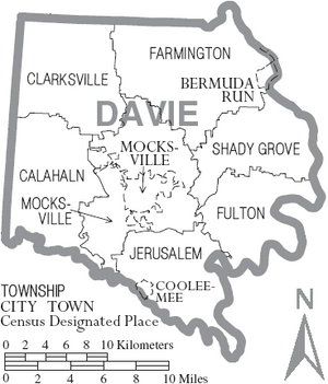
Since 1868, all counties in North Carolina have been divided into smaller areas called townships. These townships help with things like the U.S. Census. Here are the townships in Davie County:
- Calahaln Township
- Clarksville Township
- Farmington Township
- Fulton Township
- Jerusalem Township
- Mocksville Township
- Shady Grove Township
Other Communities
There are also some smaller, unincorporated communities in the county:
Census-Designated Place
- Advance is a place that the U.S. Census Bureau counts as a specific area, but it's not an officially incorporated town.
Local Post Offices
Davie County has had these main post offices for a long time:
- Advance (since 1877)
- Cooleemee (since 1900)
- Mocksville (since 1830, even before Davie County was formed)
See also
 In Spanish: Condado de Davie para niños
 | Jessica Watkins |
 | Robert Henry Lawrence Jr. |
 | Mae Jemison |
 | Sian Proctor |
 | Guion Bluford |


