
Mocksville, North Carolina facts for kids
Quick facts for kids
Mocksville, North Carolina
|
||
|---|---|---|

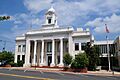
Davie County Courthouse, Courthouse Square, September 2013
|
||
|
||
| Motto(s):
"Time Well Spent"
|
||

Location of Mocksville, North Carolina
|
||
| Country | United States | |
| State | North Carolina | |
| County | Davie | |
| Area | ||
| • Total | 7.79 sq mi (20.17 km2) | |
| • Land | 7.77 sq mi (20.12 km2) | |
| • Water | 0.02 sq mi (0.05 km2) | |
| Elevation | 810 ft (250 m) | |
| Population
(2020)
|
||
| • Total | 5,900 | |
| • Density | 759.53/sq mi (293.25/km2) | |
| Time zone | UTC-5 (Eastern (EST)) | |
| • Summer (DST) | UTC-4 (EDT) | |
| ZIP code |
27028
|
|
| Area code(s) | 336 | |
| FIPS code | 37-43720 | |
| GNIS feature ID | 1021506 | |

Mocksville is a town in Davie County, North Carolina, USA. In 2020, about 5,900 people lived here. It's the main town, or county seat, of Davie County. Big roads like I-40 and Route 64 help people travel to nearby cities like Winston-Salem and Statesville.
Contents
History of Mocksville
Mocksville became an official town in 1839. It was named after a person who owned the land a long time ago. People used to call the area "Mocks Old Field."
Many old buildings and areas in Mocksville are special. They are listed on the National Register of Historic Places. This means they are important to history and are protected. Some of these places include:
- George E. Barnhardt House
- Boxwood Lodge
- Cana Store and Post Office
- Jesse Clement House
- Cooleemee
- Davie County Courthouse
- Davie County Jail
- Downtown Mocksville Historic District
- Hinton Rowan Helper House
- Hodges Business College
- McGuire-Setzer House
- North Main Street Historic District
- Salisbury Street Historic District
Geography and Climate of Mocksville
Mocksville is located in the southern part of Davie County. Important roads like US 64 and US 601 go through the town. U.S. Route 158 also starts in the town center.
Interstate 40 is a big highway that passes about 3 miles northwest of Mocksville. You can get to it from Exits 168 (US 64) and 170 (US 601).
The town covers about 7.79 square miles (20.17 square kilometers). Most of this area is land. Only a very small part, about 0.02 square miles (0.05 square kilometers), is water.
Mocksville is also home to a special rock formation. It's called the Mocksville complex. This area has different types of rocks, including Farmington Gabbro.
Mocksville's Weather
Mocksville has a humid subtropical climate. This means it has hot, humid summers and mild winters. It's known as "Cfa" on climate maps.
The hottest temperature ever recorded in Mocksville was 103°F (39°C). This happened on August 20-21, 1983, and again on August 10, 2007. The coldest temperature ever recorded was -7°F (-22°C) on February 5, 1996.
| Climate data for Mocksville, North Carolina, 1991–2020 normals, extremes 1893–present | |||||||||||||
|---|---|---|---|---|---|---|---|---|---|---|---|---|---|
| Month | Jan | Feb | Mar | Apr | May | Jun | Jul | Aug | Sep | Oct | Nov | Dec | Year |
| Record high °F (°C) | 77 (25) |
81 (27) |
89 (32) |
97 (36) |
98 (37) |
99 (37) |
101 (38) |
103 (39) |
97 (36) |
96 (36) |
83 (28) |
80 (27) |
103 (39) |
| Mean maximum °F (°C) | 69.7 (20.9) |
72.8 (22.7) |
80.3 (26.8) |
85.7 (29.8) |
89.6 (32.0) |
93.7 (34.3) |
95.7 (35.4) |
94.9 (34.9) |
91.1 (32.8) |
85.6 (29.8) |
77.8 (25.4) |
70.9 (21.6) |
96.8 (36.0) |
| Mean daily maximum °F (°C) | 49.3 (9.6) |
53.1 (11.7) |
61.0 (16.1) |
70.5 (21.4) |
77.2 (25.1) |
84.2 (29.0) |
87.7 (30.9) |
86.2 (30.1) |
80.4 (26.9) |
71.2 (21.8) |
61.3 (16.3) |
52.6 (11.4) |
69.6 (20.9) |
| Daily mean °F (°C) | 37.1 (2.8) |
40.1 (4.5) |
47.1 (8.4) |
56.3 (13.5) |
64.8 (18.2) |
72.8 (22.7) |
76.7 (24.8) |
75.5 (24.2) |
69.1 (20.6) |
57.7 (14.3) |
47.3 (8.5) |
40.4 (4.7) |
57.1 (13.9) |
| Mean daily minimum °F (°C) | 24.8 (−4.0) |
27.0 (−2.8) |
33.2 (0.7) |
42.2 (5.7) |
52.5 (11.4) |
61.3 (16.3) |
65.7 (18.7) |
64.8 (18.2) |
57.8 (14.3) |
44.2 (6.8) |
33.3 (0.7) |
28.1 (−2.2) |
44.6 (7.0) |
| Mean minimum °F (°C) | 8.5 (−13.1) |
12.5 (−10.8) |
17.7 (−7.9) |
26.8 (−2.9) |
36.8 (2.7) |
49.4 (9.7) |
56.8 (13.8) |
54.9 (12.7) |
44.2 (6.8) |
28.6 (−1.9) |
19.1 (−7.2) |
14.9 (−9.5) |
6.7 (−14.1) |
| Record low °F (°C) | −6 (−21) |
−7 (−22) |
4 (−16) |
12 (−11) |
29 (−2) |
40 (4) |
50 (10) |
42 (6) |
35 (2) |
21 (−6) |
11 (−12) |
1 (−17) |
−7 (−22) |
| Average precipitation inches (mm) | 3.75 (95) |
3.27 (83) |
4.20 (107) |
4.11 (104) |
3.61 (92) |
4.10 (104) |
4.27 (108) |
4.63 (118) |
4.07 (103) |
3.31 (84) |
3.58 (91) |
3.98 (101) |
46.88 (1,190) |
| Average snowfall inches (cm) | 1.9 (4.8) |
0.5 (1.3) |
0.4 (1.0) |
0.0 (0.0) |
0.0 (0.0) |
0.0 (0.0) |
0.0 (0.0) |
0.0 (0.0) |
0.0 (0.0) |
0.0 (0.0) |
0.1 (0.25) |
1.6 (4.1) |
4.5 (11.45) |
| Average precipitation days (≥ 0.01 in) | 8.7 | 8.5 | 10.1 | 9.6 | 10.5 | 10.6 | 9.8 | 10.4 | 8.6 | 7.0 | 7.8 | 9.1 | 110.7 |
| Average snowy days (≥ 0.1 in) | 0.8 | 0.6 | 0.3 | 0.0 | 0.0 | 0.0 | 0.0 | 0.0 | 0.0 | 0.0 | 0.0 | 0.4 | 2.1 |
| Source 1: NOAA | |||||||||||||
| Source 2: National Weather Service | |||||||||||||
People of Mocksville
Mocksville has grown quite a bit over the years. Here's how the population has changed:
| Historical population | |||
|---|---|---|---|
| Census | Pop. | %± | |
| 1860 | 710 | — | |
| 1870 | 300 | −57.7% | |
| 1880 | 562 | 87.3% | |
| 1900 | 745 | — | |
| 1910 | 1,063 | 42.7% | |
| 1920 | 1,146 | 7.8% | |
| 1930 | 1,503 | 31.2% | |
| 1940 | 1,607 | 6.9% | |
| 1950 | 1,909 | 18.8% | |
| 1960 | 2,379 | 24.6% | |
| 1970 | 2,529 | 6.3% | |
| 1980 | 2,637 | 4.3% | |
| 1990 | 3,399 | 28.9% | |
| 2000 | 4,178 | 22.9% | |
| 2010 | 5,051 | 20.9% | |
| 2020 | 5,900 | 16.8% | |
| U.S. Decennial Census | |||
Mocksville's Population in 2020
In 2020, there were 5,900 people living in Mocksville. These people made up 2,062 households and 1,307 families.
Here's a look at the different groups of people living in Mocksville in 2020:
| Group | Number | Percentage |
|---|---|---|
| White (not Hispanic) | 3,790 | 64.24% |
| Black or African American (not Hispanic) | 834 | 14.14% |
| Native American | 16 | 0.27% |
| Asian | 58 | 1.15% |
| Pacific Islander | 1 | 0.02% |
| Other/Mixed | 305 | 5.17% |
| Hispanic or Latino | 886 | 15.02% |
Famous People from Mocksville
Many interesting people have connections to Mocksville:
- Daniel Boone – A famous explorer who lived near Mocksville from 1750 to 1766. His father, Squire Boone Sr., was a local judge. Both his parents are buried in Mocksville's Joppa Cemetery.
- Clint Bowyer – A well-known NASCAR race car driver.
- Andrew Brock – A former state Senator in North Carolina.
- Thomas Ferebee – He was the bombardier on the Enola Gay plane during World War II.
- Joe Gibbs – A very successful coach in the NFL (football) and a NASCAR team owner. He is in the Pro Football Hall of Fame.
- Bob Gosse – A film producer and director.
- Hinton Rowan Helper – An important writer who was against slavery. His home in Mocksville, Hinton Rowan Helper House, is now a special monument.
- Julia C. Howard – A member of the North Carolina General Assembly, which makes laws for the state.
- Caleb Martin – An NBA basketball player for the Miami Heat.
- Cody Martin – An NBA basketball player for the Charlotte Hornets.
- Whit Merrifield – A MLB player for the Atlanta Braves.
Images for kids
-
Davie County Courthouse, Courthouse Square, September 2013
-
Town Seal of Mocksville, North Carolina
-

Location of Mocksville, North Carolina
See also
 In Spanish: Mocksville para niños
