South Mountains State Park facts for kids
Quick facts for kids South Mountains State Park |
|
|---|---|
|
IUCN Category III (Natural Monument)
|
|

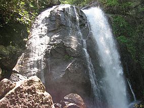
High Shoals Falls at South Mountains State Park
|
|
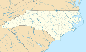
| Location | Burke, North Carolina, United States |
| Area | 20,949 acres (84.78 km2) |
| Established | 1975 |
| Named for | South Mountains |
| Governing body | North Carolina Division of Parks and Recreation |
| Website | South Mountains State Park |
South Mountains State Park is a large state park in Burke County, North Carolina, United States. It is located near Connellys Springs. The park covers about 20,949 acres (84.78 km²) and is part of the South Mountains. These mountains are a branch of the larger Blue Ridge Mountains. One of the most popular spots in the park is High Shoals Falls.
Contents
Park History and Nature
The South Mountains are a group of peaks and hills. They were formed by erosion from the Blue Ridge Mountains. These mountains cover a large area of 100,000 acres (404 km²). They stretch across Burke, Cleveland, and Rutherford counties.
Early Inhabitants and Gold Rush
Long ago, the Catawba Valley was an important travel route. The South Mountains acted as a safe zone between the Cherokee and Catawba Indians. The first European settlers farmed the rich land along the Catawba River.
In 1828, people found gold at Brindle Creek. It is said that gold was first seen in mud used to seal a log cabin. This discovery led to a gold rush. Many people came to the area, including immigrants and mining companies. Gold mining continued into the early 1900s. However, the mining activity eventually slowed down.
Park Creation and Development
Work on what is now South Mountains State Park started in the 1930s. A camp called Camp Dryer was set up at Enola. This camp was part of the Civilian Conservation Corps (CCC). The CCC was a program that helped people find jobs during tough economic times. Workers at the camp built roads, cleaned streams, and built a forest observation tower. Some of these roads, like the Lower and Upper CCC roads, are still used in the park today.
The idea for the park began in the 1940s. However, it was not until 1974 that money was set aside to buy the land. The first purchase was 5,779 acres (23.39 km²). More land has been added since then. Today, the park is 20,949 acres (84.78 km²) in size.
Mountains and Waterfalls
Most high points in the park are about 2,000 feet (609 m tall). But Buzzard's Roost is much taller, reaching about 3,000 feet (914 m). This makes it a very high point in the area. The park's elevation ranges from less than 1,200 feet (365 m) along the Jacob's Fork River to 3,000 feet (914 m) on Buzzard's Roost.
Water flows through the park and into the Catawba River. This water carves deep into the land, creating steep slopes. A special part of the park is High Shoals Falls on the Jacob's Fork River. Here, a lot of water drops 80 feet (24 m) over a bare rock cliff. It is a beautiful sight to see.
Park Hours
The park is open every day except Christmas Day. The main park gate is locked overnight.
- December, January, and February: Open until 7 PM
- November: Open until 8 PM
- March, April, and October: Open until 9 PM
- May - September: Open until 10 PM
- Closed: Christmas Day
 | Emma Amos |
 | Edward Mitchell Bannister |
 | Larry D. Alexander |
 | Ernie Barnes |


