Valdese, North Carolina facts for kids
Quick facts for kids
Valdese, North Carolina
|
|||
|---|---|---|---|

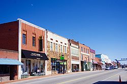
Main Street (US 70)
|
|||
|
|||

Location of Valdese, North Carolina
|
|||
| Country | United States | ||
| State | North Carolina | ||
| County | Burke | ||
| Incorporated | 1920 | ||
| Area | |||
| • Total | 7.87 sq mi (20.39 km2) | ||
| • Land | 7.86 sq mi (20.36 km2) | ||
| • Water | 0.01 sq mi (0.03 km2) | ||
| Elevation | 1,194 ft (364 m) | ||
| Population
(2020)
|
|||
| • Total | 4,689 | ||
| • Density | 596.56/sq mi (230.35/km2) | ||
| Time zone | UTC-5 (Eastern (EST)) | ||
| • Summer (DST) | UTC-4 (EDT) | ||
| ZIP code |
28690
|
||
| Area code(s) | 828 | ||
| FIPS code | 37-69520 | ||
| GNIS feature ID | 2406784 | ||
Valdese (/ˈvældis/ VAL-dees) is a town in Burke County, North Carolina, United States. In 2020, about 4,689 people lived there. It is part of a larger area that includes the cities of Hickory, Lenoir, and Morganton.
Valdese was founded by a group of people called Waldensians. They came from the Cottian Alps in the Piedmont region of Italy. Today, one of the biggest Waldensian churches in the United States is in Valdese. It is called the Waldensian Presbyterian Church.
Contents
History of Valdese
Valdese was first settled in 1893 by Waldensians from Northern Italy. The town officially became a town in 1920. The story of how the town started is told in an outdoor play. This play is called From This Day Forward. It has been performed every year in Burke County since 1968.
Two important buildings in Valdese are listed on the National Register of Historic Places. These are the Jean-Pierre Auguste Dalmas House and the Valdese Elementary School. These places are recognized for their historical importance.
Geography and Location
Valdese is located in the eastern part of Burke County. To its east, it shares a border with the town of Rutherford College. The town's northern edge reaches Rhodhiss Lake, which is part of the Catawba River. The town limits follow the southern side of the lake for about 4 miles (6 km) to the west.
U.S. Route 70 runs through Valdese. It is known as Main Street in town. This road goes west about 7 miles (11 km) to Morganton, which is the county seat. It goes east about 14 miles (23 km) to Hickory. Interstate 40 is a major highway that runs along the southern edge of Valdese. You can get to Valdese from exits 111 and 112 on I-40.
The town covers a total area of about 7.7 square miles (20.0 km2). Only a very small part, about 0.012 square miles (0.03 km2) or 0.17%, is water.
People of Valdese
| Historical population | |||
|---|---|---|---|
| Census | Pop. | %± | |
| 1930 | 1,816 | — | |
| 1940 | 2,615 | 44.0% | |
| 1950 | 2,730 | 4.4% | |
| 1960 | 2,941 | 7.7% | |
| 1970 | 3,182 | 8.2% | |
| 1980 | 3,364 | 5.7% | |
| 1990 | 3,914 | 16.3% | |
| 2000 | 4,485 | 14.6% | |
| 2010 | 4,490 | 0.1% | |
| 2020 | 4,689 | 4.4% | |
| U.S. Decennial Census | |||
Valdese Population in 2020
| Group | Number | Percentage |
|---|---|---|
| White (not Hispanic) | 4,097 | 87.37% |
| Black or African American (not Hispanic) | 77 | 1.64% |
| Native American | 1 | 0.02% |
| Asian | 160 | 3.41% |
| Pacific Islander | 10 | 0.21% |
| Other/Mixed | 183 | 3.9% |
| Hispanic or Latino | 161 | 3.43% |
In 2020, there were 4,689 people living in Valdese. There were 1,545 households and 1,104 families.
Valdese has a large community of people with Italian heritage. It also has a big Hmong-American community. Hmong people are an ethnic group from Southeast Asia, with roots in countries like Laos, Thailand, China, and Vietnam. You can find Italian restaurants and bakeries in the Valdese area. There is also a Hmong/Southeast Asian store called Xieng Khouang Market Place in Valdese.
Notable People from Valdese
Here are some well-known people who are from Valdese:
- Hugh Blackwell – a member of the North Carolina House of Representatives.
- Bill Cline – a player in the CFL.
- Doug Cline – an AFL linebacker for the Houston Oilers and San Diego Chargers.
- J. Bazzel Mull – a Christian minister and religious broadcaster.
- Stanley Pons – a scientist who studies electrochemistry.
- Tyler Shatley – an NFL offensive guard for the Jacksonville Jaguars.
- George Shuffler – a bluegrass musician.
- Alabama Pitts – a professional athlete.
Sister City Connection
Valdese has one sister city. A sister city is a town or city that forms a special bond with another city in a different country. This helps people from both places learn about each other's cultures.
See also
 In Spanish: Valdese para niños
 | Misty Copeland |
 | Raven Wilkinson |
 | Debra Austin |
 | Aesha Ash |


