Henderson County, North Carolina facts for kids
{{Infobox U.S. county | county = Henderson County | state = North Carolina | seal = Henderson County Seal.png | founded = 1838 | named for = Leonard Henderson | seat wl = Hendersonville | largest city wl = Hendersonville | city type = community | area_total_sq_mi = 375.09 | area_land_sq_mi = 372.95 | area_water_sq_mi = 2.14 | area percentage = 0.57 | population_as_of = 2020 | population_total = 116281 | pop_est_as_of = 2023 | population_est = 119230 ![]() | density_sq_mi = auto | coordinates = 35°20′N 82°29′W / 35.34°N 82.48°W | time zone = Eastern | web = www.hendersoncountync.gov | ex image = Henderson courthouse 9239.JPG | ex image cap = Henderson County Courthouse | district = 11th | flag = Henderson County Flag.gif
| density_sq_mi = auto | coordinates = 35°20′N 82°29′W / 35.34°N 82.48°W | time zone = Eastern | web = www.hendersoncountync.gov | ex image = Henderson courthouse 9239.JPG | ex image cap = Henderson County Courthouse | district = 11th | flag = Henderson County Flag.gif
Henderson County is a county located in the U.S. state of North Carolina. In 2020, about 116,281 people lived here. The main town and county seat is Hendersonville. Henderson County is part of the larger Asheville, NC Metropolitan Statistical Area.
Contents
History of Henderson County
Henderson County was created in 1838. It was formed from the southern part of Buncombe County. The county was named after Leonard Henderson. He was a very important judge, serving as the Chief Justice of the North Carolina Supreme Court from 1829 to 1833.
Over time, parts of Henderson County were used to create other counties. In 1855, some land from Henderson County and Rutherford County became Polk County. Later, in 1861, parts of Henderson County and Jackson County formed Transylvania County.
During the American Civil War, Henderson County had about 10,000 people. Many soldiers from the county joined the Confederate States Army. A smaller number also joined the Union troops.
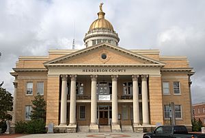
For many years, the county government was located in the 1905 county courthouse in Hendersonville. A new courthouse was built around 1995. The old building is now used as a museum.
In 1879, the first train tracks reached Hendersonville. This made it easier for people and goods to travel in and out of the area. Before this, some parts of the county were already popular getaway spots. For example, Flat Rock was known as "Little Charleston." Wealthy families from South Carolina had second homes there since the early 1800s.
The county saw a big increase in land sales in the 1920s. However, this boom ended with the economic crash of 1929. This caused prices to drop a lot. Since the 1960s, many people from other states have moved to Henderson County. This has led to fast population growth and new housing developments.
Some other important historical places in Henderson County include the Woodfield Inn (built in 1852). There's also Connemara, which was the last home of the famous writer Carl Sandburg. Today, Flat Rock is home to Blue Ridge Community College. It also has the Flat Rock Playhouse, which is North Carolina's state theater.
Geography and Nature
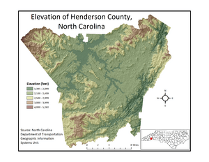
Henderson County is located in the Blue Ridge Mountains in southwestern North Carolina. It shares a border with South Carolina. The Eastern Continental Divide runs through the county. This divide separates rivers that flow to the Atlantic Ocean from those that flow to the Gulf of Mexico.
The county has a total area of about 375 square miles. Most of this (373 square miles) is land, and about 2.2 square miles (0.6%) is water. The biggest lake in the county is Lake Summit. This lake was created by Duke Power Company to make electricity.
Major rivers and streams in the county include the French Broad River, Mills River, Green River, and the headwaters of the Broad River. The French Broad River eventually flows into the Tennessee River, then the Ohio River, and finally the Mississippi River to the Gulf of Mexico. The Broad River flows into the Congaree River in South Carolina and then to the Atlantic Ocean.
The lowest point in the county is about 1,394 feet high, along the Broad River. The highest point is on Little Pisgah Mountain, which is about 5,278 feet high.
Weather and Landscape
Henderson County has a wide range of temperatures and rainfall. This is because of its location along the Eastern Continental Divide and its varied landscape. Higher areas are usually cooler and get more rain. Lower valleys are warmer and drier.
The average yearly temperature in the county is about 55.1°F. July is the warmest month, with an average temperature of about 72.6°F. January is the coolest month, with an average of about 36.9°F.
The county gets about 56.2 inches of rain each year on average. March usually has the most rain, while October has the least.
Farming in Henderson County
Henderson County's different landscapes and climates make it great for growing many kinds of crops. The area between the Pisgah National Forest and Polk County is known as the "Crest of the Blue Ridge Agricultural Area." This area has special conditions for growing plants.
Many fruits and berries are grown here, including:
- Apples
- Blackberries
- Blueberries
- Peaches
- Strawberries
Apples are the most important crop in the county. They need cold winters and don't like hot, humid summers. Henderson County's cooler climate is perfect for apple orchards. It's the southernmost place in the eastern United States where apples are grown on a large scale. Each year, the county celebrates its apple industry with the North Carolina Apple Festival. This festival happens around Labor Day and includes the "King Apple Parade."
Many vegetables are also grown in Henderson County, such as:
- Green beans
- Broccoli
- Cabbage
- Corn
- Tomatoes
- Pumpkins
Farmers also produce meat, eggs, and dairy products. These include beef, mountain trout, pork, poultry, and cheese.
Protected Natural Areas
Henderson County is home to several important natural areas:
- Blue Ridge Parkway (part)
- Carl Sandburg Home National Historic Site
- Pisgah National Forest (part)
There are also state and local protected areas:
- Chimney Rock State Park (part)
- DuPont State Recreational Forest (part)
- Florence Nature Preserve
- Holmes Educational State Forest (part)
Major Rivers and Lakes
Neighboring Counties
Henderson County shares borders with these counties:
- Buncombe County – to the north
- Rutherford County – to the northeast
- Polk County – to the east
- Greenville County, South Carolina – to the south
- Transylvania County – to the west
- Haywood County – to the northwest
Main Roads
 I-26
I-26 US 25
US 25 US 64
US 64 US 74
US 74 US 176
 NC 9
NC 9 NC 191
 NC 280
People of Henderson County
| Historical population | |||
|---|---|---|---|
| Census | Pop. | %± | |
| 1840 | 5,129 | — | |
| 1850 | 6,853 | 33.6% | |
| 1860 | 10,448 | 52.5% | |
| 1870 | 7,706 | −26.2% | |
| 1880 | 10,281 | 33.4% | |
| 1890 | 12,589 | 22.4% | |
| 1900 | 14,104 | 12.0% | |
| 1910 | 16,262 | 15.3% | |
| 1920 | 18,248 | 12.2% | |
| 1930 | 23,404 | 28.3% | |
| 1940 | 26,049 | 11.3% | |
| 1950 | 30,921 | 18.7% | |
| 1960 | 36,163 | 17.0% | |
| 1970 | 42,804 | 18.4% | |
| 1980 | 58,580 | 36.9% | |
| 1990 | 69,285 | 18.3% | |
| 2000 | 89,173 | 28.7% | |
| 2010 | 106,740 | 19.7% | |
| 2020 | 116,281 | 8.9% | |
| 2023 (est.) | 119,230 | 11.7% | |
| U.S. Decennial Census 1790–1960 1900–1990 1990–2000 2010 2020 |
|||
Population in 2020
In 2020, there were 116,281 people living in Henderson County. There were 51,115 households and 33,992 families.
| Group | Number | Percentage |
|---|---|---|
| White (not Hispanic) | 91,747 | 78.9% |
| Black or African American (not Hispanic) | 3,299 | 2.84% |
| Native American | 284 | 0.24% |
| Asian | 1,296 | 1.11% |
| Pacific Islander | 241 | 0.21% |
| Other/Mixed backgrounds | 4,415 | 3.8% |
| Hispanic or Latino | 14,999 | 12.9% |
Ancestry and Backgrounds
As of 2015, the largest groups of people based on their family history were:
| Ancestry | Percent (2015) |
|---|---|
| English |
15.4% |
| American |
13.9% |
| German |
13.4% |
| Irish |
12.2% |
| Scotch-Irish |
4.7% |
| Scottish |
4.0% |
| Italian |
3.5% |
| French |
2.1% |
| Polish |
1.8% |
| Dutch |
1.5% |
Religious Groups
As of 2018, the largest religious groups in Henderson County were:
| Religion | Percent (2018) |
|---|---|
| Unaffiliated (no specific religion) | 44% |
| Baptist | 23% |
| Other | 15% |
| Methodist | 13.4% |
| Catholic | 4.0% |
| Presbyterian | 3.0% |
| Anglican | 2.0% |
| Seventh-day Adventist | 2.0% |
| Lutheran | 1.0% |
| Pentecostal | 1.0% |
Historically, Henderson County was part of the Cherokee Nation. The Cherokee people were later forced to leave their lands in 1837–38 during the Trail of Tears.
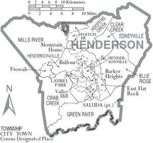
Towns and Communities
Cities
- Hendersonville (This is the county seat and the largest community.)
- Saluda
Towns
- Fletcher
- Laurel Park
- Mills River
Village
Census-designated places
These are areas that are like towns but are not officially incorporated:
Unincorporated communities
These are smaller communities that are not part of any city or town:
Townships
Townships are smaller divisions of the county, often used for local administration:
- Blue Ridge
- Clear Creek
- Crab Creek
- Edneyville
- Green River
- Hendersonville
- Hoopers Creek
- Mills River
See also
 In Spanish: Condado de Henderson (Carolina del Norte) para niños
 | Janet Taylor Pickett |
 | Synthia Saint James |
 | Howardena Pindell |
 | Faith Ringgold |


