Transylvania County, North Carolina facts for kids
Quick facts for kids
Transylvania County
|
|||
|---|---|---|---|

Transylvania County Courthouse in Brevard
|
|||
|
|||
| Nickname(s):
Land of Waterfalls
|
|||
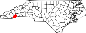
Location within the U.S. state of North Carolina
|
|||
 North Carolina's location within the U.S. |
|||
| Country | |||
| State | |||
| Founded | 1861 | ||
| Named for | Latin word meaning "Across the Woods" | ||
| Seat | Brevard | ||
| Largest community | Brevard | ||
| Area | |||
| • Total | 380.33 sq mi (985.1 km2) | ||
| • Land | 378.36 sq mi (979.9 km2) | ||
| • Water | 1.97 sq mi (5.1 km2) 0.52% | ||
| Population
(2020)
|
|||
| • Total | 32,986 | ||
| • Estimate
(2023)
|
33,549 | ||
| • Density | 87.18/sq mi (33.66/km2) | ||
| Time zone | UTC−5 (Eastern) | ||
| • Summer (DST) | UTC−4 (EDT) | ||
| Congressional district | 11th | ||
Transylvania County is a county located in the beautiful state of North Carolina, USA. It's known for its stunning natural beauty and many waterfalls. In 2020, about 32,986 people lived here. The main town and county seat is Brevard.
This county is part of the Brevard, NC Micropolitan Statistical Area. It's also included in the larger Asheville-Waynesville-Brevard, NC Combined Statistical Area.
Contents
History of Transylvania County
Transylvania County was officially created on February 15, 1861. It was formed from parts of nearby Jackson and Henderson counties. Joseph P. Jordan, a representative, gave the county its name. For many years, most people in Transylvania County were farmers. They grew crops like potatoes and cabbage to make a living.
In the early 1900s, the county started to develop factories. Joseph Silverstein opened a tannery in a place that became known as Rosman in 1905. These factories used timber and other products from the Pisgah National Forest. In the 1930s, Harry Straus opened a paper mill. This mill, called Ecusta Paper, became very important. By the mid-1900s, it employed over 3,000 local people. During the 1950s, a company called DuPont also had a factory here, providing jobs for nearly 1,000 more residents.
Over time, Brevard College and the town of Brevard grew a lot. The Brevard Music Center also started its summer music festival. This event began to attract musicians and music lovers from all over the country to Transylvania County.
Since the late 1900s, the county's economy has changed again. Many factories, like Ecusta and DuPont, closed or moved their operations to other countries. Because of this, Transylvania County has focused on tourism. It has become a popular place for summer and winter visitors in the Appalachian Mountains.
Exploring Transylvania County's Geography
Transylvania County covers about 380 square miles. Most of this area, about 378 square miles, is land. The rest is water.
The county is home to the main starting points of the French Broad River. These are called the North Fork, West Fork, East Fork, and Middle Fork. All these smaller rivers begin right here in the county. The French Broad River then flows mostly east and north into Henderson County.
The northern border of the county follows the mountain ridges near the Blue Ridge Parkway. The southern border mostly follows the Eastern Continental Divide. This is a line where water on one side flows to the Atlantic Ocean and water on the other side flows to the Gulf of Mexico.
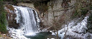
Transylvania County is famous as the "Land of Waterfalls." It has more than 250 waterfalls! This is because it gets a lot of rain and is located on the Blue Ridge Escarpment, a steep slope. Some famous waterfalls include Looking Glass Falls, Moore Cove Falls, Rainbow Falls, and Whitewater Falls. Whitewater Falls is the tallest waterfall east of the Mississippi River. The county receives over 90 inches of rain each year, making it the wettest county in North Carolina. The Blue Ridge Parkway also runs through parts of the county. It offers amazing views of the Appalachian Mountains, which reach over 6,000 feet high here.
Protected Natural Areas
Transylvania County has several important protected areas. These places help keep the natural environment safe and beautiful.
National Protected Areas
- Blue Ridge Parkway (part of it is in the county)
- Nantahala National Forest (part of it is in the county)
- Pisgah National Forest (part of it is in the county)
State and Local Protected Areas
- Biltmore Forest School
- Bracken Preserve
- Davidson River Recreational Area
- Dupont State Forest Game Land (part)
- DuPont State Recreational Forest (part)
- Gorges State Park
- Headwaters State Forest
- Headwaters State Forest Game Land
- Pisgah National Forest Game Land (part)
- Southern Highlands Reserve (part)
- Sycamore Flats Recreational Area
- Toxaway Game Land
Major Water Bodies
The county is home to many lakes and rivers.
- Atagahi Lake
- Camp Creek Falls
- Cascade Lake
- Dupont Lake
- French Broad River
- Horsepasture River
- Kings Creek
- Lake Jocassee
- Lake Julia
- Lake Toxaway
- Lake Wanteska
- Little River
- North Fork French Broad River
- Shoal Creek
- South Fork Flat Creek
- Thunder Lake
- Thompson River
- Ticoa Lake
- Toxaway Creek
Neighboring Counties
Transylvania County shares borders with several other counties:
- Henderson County – to the east
- Greenville County, South Carolina – to the southeast
- Pickens County, South Carolina – to the south
- Oconee County, South Carolina – to the southwest
- Jackson County – to the west
- Haywood County – to the northwest
- Buncombe County – to the northeast
Main Roads and Highways
These are the major roads that help people travel through Transylvania County:
 US 64
US 64
 US 64 Bus.
 US 178
 US 276
 NC 215
 NC 280
 NC 281
People and Population (Demographics)
| Historical population | |||
|---|---|---|---|
| Census | Pop. | %± | |
| 1870 | 3,536 | — | |
| 1880 | 5,340 | 51.0% | |
| 1890 | 5,881 | 10.1% | |
| 1900 | 6,620 | 12.6% | |
| 1910 | 7,191 | 8.6% | |
| 1920 | 9,303 | 29.4% | |
| 1930 | 9,589 | 3.1% | |
| 1940 | 12,241 | 27.7% | |
| 1950 | 15,194 | 24.1% | |
| 1960 | 16,372 | 7.8% | |
| 1970 | 19,713 | 20.4% | |
| 1980 | 23,417 | 18.8% | |
| 1990 | 25,520 | 9.0% | |
| 2000 | 29,334 | 14.9% | |
| 2010 | 33,090 | 12.8% | |
| 2020 | 32,986 | −0.3% | |
| 2023 (est.) | 33,549 | 1.4% | |
| U.S. Decennial Census 1790–1960 1900–1990 1990–2000 2010 2020 |
|||
Population in 2020
| Race / Ethnicity (NH = Non-Hispanic) | Pop 2000 | Pop 2010 | Pop 2020 | % 2000 | % 2010 | % 2020 |
|---|---|---|---|---|---|---|
| White alone (NH) | 27,305 | 30,049 | 28,542 | 93.08% | 90.81% | 86.53% |
| Black or African American alone (NH) | 1,228 | 1,279 | 1,027 | 4.19% | 3.87% | 3.11% |
| Native American or Alaska Native alone (NH) | 76 | 93 | 102 | 0.26% | 0.28% | 0.31% |
| Asian alone (NH) | 111 | 143 | 173 | 0.38% | 0.43% | 0.52% |
| Native Hawaiian or Pacific Islander alone (NH) | 7 | 8 | 22 | 0.02% | 0.02% | 0.07% |
| Other race alone (NH) | 13 | 33 | 115 | 0.04% | 0.10% | 0.35% |
| Mixed race or Multiracial (NH) | 296 | 521 | 1,307 | 1.01% | 1.57% | 3.96% |
| Hispanic or Latino (any race) | 298 | 964 | 1,698 | 1.02% | 2.91% | 5.15% |
| Total | 29,334 | 33,090 | 32,986 | 100.00% | 100.00% | 100.00% |
In 2020, there were 32,986 people living in Transylvania County. There were 14,567 households and 9,978 families.
Population in 2010
In 2010, the county had 33,090 people. There were 14,394 households and 8,660 families. The population density was about 83 people per square mile. There were 15,553 housing units.
Most people in the county were White (92.4%). About 3.9% were Black or African American. About 0.3% were Native American, and 0.4% were Asian. About 1.12% of people were from two or more races. About 2.9% of the population identified as Hispanic or Latino.
About 25.10% of households had children under 18 living with them. About 58.60% were married couples. About 26.10% of all households were single individuals. About 12.40% had someone living alone who was 65 or older. The average household had 2.30 people. The average family had 2.74 people.
The population was spread out by age. About 20.40% were under 18. About 21.40% were 65 or older. The average age was 44 years.
Fun Places to Visit (Points of Interest)
Transylvania County has many interesting places to see and things to do:
- Biltmore Forest School: This was the very first school in North America for studying forestry.
- Blue Ridge Community College: It has a campus in Transylvania County.
- Blue Ridge Parkway: A famous scenic road with amazing views.
- Brevard College: A local college.
- Brevard Little Theater: A place to watch plays and performances.
- Brevard Music Center: A well-known music school and festival.
- DuPont State Forest: A large forest perfect for hiking and exploring.
- Gorges State Park: A state park with beautiful gorges and waterfalls.
- Lake Toxaway: A large, beautiful lake.
- Looking Glass Falls: A popular and easy-to-access waterfall.
- Nantahala National Forest: Another large national forest.
- Pisgah Astronomical Research Institute: A place for studying space.
- Pisgah National Forest: A vast forest with many outdoor activities.
- Sliding Rock: A natural rock waterslide, very popular in summer.
- Transylvania Arts Council: Supports arts and culture in the county.
- Transylvania County Schools: The local school system.
- Whitewater Falls: The tallest waterfall in North Carolina.
Communities in Transylvania County
Here are the different towns and communities you can find in Transylvania County:
City
- Brevard: This is the county seat and the largest community.
Town
Townships
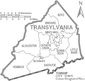
- Boyd
- Brevard
- Cathey's Creek
- Dunn's Rock
- Eastatoe
- Gloucester
- Hogback
- Little River
Unincorporated Communities
These are smaller communities that are not officially towns or cities.
- Balsam Grove
- Cathey's Creek
- Cedar Mountain
- Connestee Falls
- Dunn's Rock
- Lake Toxaway
- Little River
- Penrose
- Pisgah Forest
- Quebec
- Sapphire
See also
 In Spanish: Condado de Transilvania para niños
 | Claudette Colvin |
 | Myrlie Evers-Williams |
 | Alberta Odell Jones |


