Rosman, North Carolina facts for kids
Quick facts for kids
Rosman, North Carolina
|
|
|---|---|

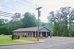
Town hall
|
|

Location of Rosman, North Carolina
|
|
| Country | United States |
| State | North Carolina |
| County | Transylvania |
| Incorporated | 1901 |
| Named for | Joseph Rosenthal and Morris Ormansky |
| Area | |
| • Total | 0.55 sq mi (1.41 km2) |
| • Land | 0.55 sq mi (1.41 km2) |
| • Water | 0.00 sq mi (0.00 km2) |
| Elevation | 2,290 ft (700 m) |
| Population
(2020)
|
|
| • Total | 701 |
| • Density | 1,283.88/sq mi (495.75/km2) |
| Time zone | UTC−5 (Eastern (EST)) |
| • Summer (DST) | UTC−4 (EDT) |
| ZIP code |
28772
|
| Area code(s) | 828 |
| FIPS code | 37-58020 |
| GNIS feature ID | 2407248 |
Rosman is a small town in Transylvania County, North Carolina, United States. In 2020, about 701 people lived there. A major road, U.S. Route 178, ends near Rosman, connecting to U.S. Route 64.
About six miles north of Rosman, you can find the Pisgah Astronomical Research Institute. This is a special place where scientists study space.
Contents
History of Rosman's Name
Rosman has had a few different names over the years! When European Americans first settled here, it was called Jeptha.
From Toxaway to Eastatoe
In the early 1900s, the settlement was known as "Toxaway." However, this caused confusion with another nearby town called Lake Toxaway. To avoid mix-ups, the name was changed in 1903 to "Eastatoe." This name came from a historic Cherokee town in the area. It was also the name for a nearby gap and falls. The Cherokee word eastatoe means "Carolina parakeet," a type of bird.
How Rosman Got Its Name
The people living in the town wanted another name change. In 1905, a local businessman named Joseph Silversteen suggested "Rosman." He named it after two of his business partners, Joseph Rosenthal and Morris Osmansky. This new name was approved, and the town has been called Rosman ever since.
Geography and Nature
Rosman is a small town. It covers about 0.55 square miles (1.41 square kilometers) of land.
Highways and Forests
Inside Rosman and to its south, U.S. Route 178 is known as Pickens Highway. This road leads to Pickens, South Carolina. South of Rosman, the highway goes through mountains with many winding curves. Rosman is also right next to the eastern edge of Pisgah National Forest, a large forest area.
The French Broad River
The French Broad River flows right through the town of Rosman. The river actually starts just west of town. This is where two smaller streams, the North Fork French Broad and the West Fork French Broad, join together to form the main river. There is a special station in Rosman that measures the river's water levels.
Rainy Climate
Rosman has a very wet climate. Since 1936, the town has received an average of about 79.54 inches (2020 mm) of rain each year. This is one of the highest rainfall amounts in the eastern United States. In 1964, Rosman had a record 129.60 inches (3292 mm) of rain. This was almost as much as the record set by Mount Washington in 1969.
People of Rosman
As of the 2020 United States census, 701 people lived in Rosman. There were 240 households and 104 families in the town. Most residents were White (81.03%), with smaller percentages of Black or African American (2.14%), Native American (1.0%), and other races (6.28%). About 9.56% of the population was Hispanic or Latino.
Camps in the Area
Rosman is home to a couple of camps. These include The Wilds Christian Camp and Conference Center and Ridge Haven. Many young people visit these camps for activities and events.
Schools in Rosman
Students in the Rosman area attend local schools. These include Rosman Elementary, TC Henderson Elementary, Rosman Middle, and Rosman High School. The sports teams at Rosman High School are known as the Tigers.
See also
 In Spanish: Rosman para niños
 | Madam C. J. Walker |
 | Janet Emerson Bashen |
 | Annie Turnbo Malone |
 | Maggie L. Walker |


