Pickens, South Carolina facts for kids
Quick facts for kids
Pickens, South Carolina
|
||
|---|---|---|

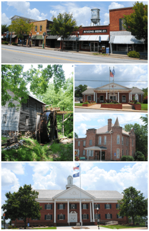
Top, left to right: Downtown Pickens, Hagood Mill, Pickens City Hall, Old Pickens Jail, Pickens County Courthouse
|
||
|
||
| Motto(s):
"Where the Mountains Begin"
|
||

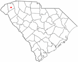
Location of Pickens, South Carolina
|
||
| Country | United States | |
| State | South Carolina | |
| County | Pickens | |
| Area | ||
| • Total | 3.06 sq mi (7.93 km2) | |
| • Land | 3.04 sq mi (7.87 km2) | |
| • Water | 0.02 sq mi (0.06 km2) | |
| Elevation | 1,109 ft (338 m) | |
| Population
(2020)
|
||
| • Total | 3,388 | |
| • Density | 1,114.84/sq mi (430.43/km2) | |
| Time zone | UTC−5 (Eastern (EST)) | |
| • Summer (DST) | UTC−4 (EDT) | |
| ZIP code |
29671
|
|
| Area codes | 864, 821 | |
| FIPS code | 45-56140 | |
| GNIS feature ID | 1250078 | |
| Website | www.cityofpickens.com | |
Pickens is a city in Pickens County, South Carolina, United States. It is the main city of the county. The city was once called Pickens Courthouse. In 2020, about 3,388 people lived there.
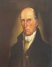
Pickens was named after Andrew Pickens. He was a soldier in the American Revolutionary War and a US Congressman. Pickens is part of a larger group of cities called the Greenville–Mauldin–Easley Metropolitan Statistical Area.
Contents
History of Pickens

The area where Pickens is today used to be land of the Cherokee people. During the American Revolutionary War, the Cherokee sided with Great Britain. After Great Britain lost the war, the Cherokee had to give up their land.
In 1791, the state created Washington District. This district included what are now Greenville, Anderson, Oconee, and Pickens Counties. In 1798, Washington District was split into Greenville and Pendleton districts.
Later, the Pendleton district was divided into Anderson, Oconee, and Pickens counties. In 1828, Pendleton District was split into Anderson and Pickens. A courthouse was built by the Keowee River. A town called Pickens Court House grew around it. The Hagood-Mauldin House, built around 1856, is one of the old buildings in Pickens County.
In 1868, the Pickens District was divided one last time into Pickens and Oconee counties. The Pickens Court House moved to its current spot, and the town was renamed Pickens. The Pickens Railway was started in 1898. It was a short train line from Easley to Pickens.
Geography and Climate
Pickens is located at 34°52′54″N 82°42′27″W / 34.88167°N 82.70750°W. The city covers about 3.06 square miles (7.93 km2). Most of this area is land, with a small part being water.
Pickens is surrounded by several small mountains. Glassy Mountain is to the east of Pickens. It is a special type of mountain called a piedmont monadnock. These are rare in South Carolina. Sixty-five acres of Glassy Mountain are protected. They have many rare plants.
One of the most famous mountains nearby is Table Rock State Park. It is just north of Pickens. Table Rock Mountain is a symbol for Pickens. You can see it from Pickens and nearby cities like Easley and Greenville. The park also has Pinnacle Mountain. This is the highest mountain completely within South Carolina.
| Climate data for Pickens, South Carolina (1991–2020 normals, extremes 1941–present) | |||||||||||||
|---|---|---|---|---|---|---|---|---|---|---|---|---|---|
| Month | Jan | Feb | Mar | Apr | May | Jun | Jul | Aug | Sep | Oct | Nov | Dec | Year |
| Record high °F (°C) | 80 (27) |
81 (27) |
89 (32) |
93 (34) |
98 (37) |
102 (39) |
106 (41) |
105 (41) |
101 (38) |
97 (36) |
85 (29) |
78 (26) |
106 (41) |
| Mean daily maximum °F (°C) | 52.5 (11.4) |
56.1 (13.4) |
63.7 (17.6) |
72.9 (22.7) |
79.8 (26.6) |
86.4 (30.2) |
89.8 (32.1) |
88.2 (31.2) |
82.9 (28.3) |
73.4 (23.0) |
63.1 (17.3) |
54.9 (12.7) |
72.0 (22.2) |
| Daily mean °F (°C) | 41.4 (5.2) |
44.4 (6.9) |
51.3 (10.7) |
59.8 (15.4) |
68.2 (20.1) |
75.8 (24.3) |
79.3 (26.3) |
78.2 (25.7) |
72.3 (22.4) |
61.3 (16.3) |
50.7 (10.4) |
44.0 (6.7) |
60.6 (15.9) |
| Mean daily minimum °F (°C) | 30.4 (−0.9) |
32.4 (0.2) |
39.0 (3.9) |
46.8 (8.2) |
56.6 (13.7) |
65.1 (18.4) |
68.9 (20.5) |
68.1 (20.1) |
61.8 (16.6) |
49.2 (9.6) |
38.2 (3.4) |
33.1 (0.6) |
49.2 (9.6) |
| Record low °F (°C) | −6 (−21) |
0 (−18) |
7 (−14) |
24 (−4) |
34 (1) |
43 (6) |
51 (11) |
52 (11) |
35 (2) |
26 (−3) |
9 (−13) |
0 (−18) |
−6 (−21) |
| Average precipitation inches (mm) | 5.24 (133) |
4.54 (115) |
4.92 (125) |
4.68 (119) |
3.98 (101) |
5.02 (128) |
4.75 (121) |
5.07 (129) |
4.54 (115) |
4.06 (103) |
4.20 (107) |
5.67 (144) |
56.67 (1,439) |
| Average snowfall inches (cm) | 0.4 (1.0) |
0.2 (0.51) |
0.0 (0.0) |
0.0 (0.0) |
0.0 (0.0) |
0.0 (0.0) |
0.0 (0.0) |
0.0 (0.0) |
0.0 (0.0) |
0.0 (0.0) |
0.0 (0.0) |
0.4 (1.0) |
1.0 (2.5) |
| Average precipitation days (≥ 0.01 in) | 9.8 | 9.5 | 10.3 | 9.4 | 9.1 | 11.1 | 11.3 | 11.3 | 8.2 | 7.4 | 8.1 | 10.1 | 115.6 |
| Average snowy days (≥ 0.1 in) | 0.2 | 0.0 | 0.0 | 0.0 | 0.0 | 0.0 | 0.0 | 0.0 | 0.0 | 0.0 | 0.0 | 0.2 | 0.4 |
| Source: NOAA | |||||||||||||
Population Data
| Historical population | |||
|---|---|---|---|
| Census | Pop. | %± | |
| 1880 | 212 | — | |
| 1890 | 283 | 33.5% | |
| 1900 | 449 | 58.7% | |
| 1910 | 897 | 99.8% | |
| 1920 | 895 | −0.2% | |
| 1930 | 1,130 | 26.3% | |
| 1940 | 1,637 | 44.9% | |
| 1950 | 1,961 | 19.8% | |
| 1960 | 2,198 | 12.1% | |
| 1970 | 2,954 | 34.4% | |
| 1980 | 3,199 | 8.3% | |
| 1990 | 3,042 | −4.9% | |
| 2000 | 3,012 | −1.0% | |
| 2010 | 3,126 | 3.8% | |
| 2020 | 3,388 | 8.4% | |
| U.S. Decennial Census | |||
2020 Census Information
In 2020, the city of Pickens had 3,388 people living there. There were 1,190 households and 764 families.
Here's a look at the different groups of people in Pickens:
| Race | Number of People | Percentage |
|---|---|---|
| White (not Hispanic) | 2,589 | 76.42% |
| Black or African American (not Hispanic) | 447 | 13.19% |
| Native American | 6 | 0.18% |
| Asian | 10 | 0.3% |
| Other/Mixed | 198 | 5.84% |
| Hispanic or Latino | 138 | 4.07% |
Historical Places to Visit
Three miles north of downtown Pickens, you can find Hagood Mill. This old grist mill was built in 1845. It worked until the 1960s. Today, it is on the National Register of Historic Places. Monthly festivals are held there to celebrate southern history. You can also buy stone-ground cornmeal and grits.
In 2003, ancient rock carvings called petroglyphs were found at Hagood Mill. They are thought to be 1,500 to 2,000 years old. They might have been made by the Hopewell culture. A museum is planned for this important historical site.
The Old Pickens Jail is another historical building. It was built in 1903. It was used as a jail and also had offices and living space for the county sheriff. This building is also on the National Register of Historic Places. Now, it is a museum for the community.
Education in Pickens
The main office for the School District of Pickens County is in Easley. Pickens city has three elementary schools, one middle school, and one high school.
- Pickens Elementary
- Hagood Elementary
- Pickens Middle
- Pickens High School
Pickens also has a public library. It is part of the Pickens County Library System.
Famous People from Pickens
- Bobby Baker
- Browning Bryant
- Sam Wyche
See also
 In Spanish: Pickens (Carolina del Sur) para niños
 | Chris Smalls |
 | Fred Hampton |
 | Ralph Abernathy |


