Mount Craig (North Carolina) facts for kids
Quick facts for kids Mount Craig |
|
|---|---|

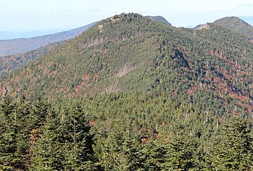
Mount Craig viewed from the summit of Mount Mitchell in 2016
|
|
| Highest point | |
| Elevation | 6,647 ft (2,026 m) |
| Prominence | 287 ft (87 m) |
| Geography | |
| Location | Yancey County, North Carolina, U.S. |
| Parent range | Appalachian Mountains |
| Topo map | USGS Mount Mitchell |
| Climbing | |
| Easiest route | Hike |
Mount Craig is a really tall mountain in North Carolina, USA! It stands at about 6,647 feet (2,026 meters) high. This makes it the second highest peak in the entire Appalachian Mountains. It's also the second highest mountain in eastern mainland North America. Only Mount Mitchell, which is super close by, is a little bit taller.
You can find Mount Craig in the Black Mountains. It's located within Yancey County, North Carolina. The mountain is about one mile (2 kilometers) north of Mount Mitchell. It's also part of both Mount Mitchell State Park and the Pisgah National Forest.
Contents
Why is it Called Mount Craig?
Mount Craig got its name from a special person named Locke Craig. He was the governor of North Carolina from 1913 to 1917. Governor Craig was very important because he helped create Mount Mitchell State Park in 1915. This park was the very first state park in North Carolina! It helped protect the beautiful mountain area from too much logging.
Hiking Trails on Mount Craig
If you love hiking, Mount Craig is a great place to visit! You can easily reach the top by taking a hike on the Deep Gap Trail. This trail starts near the picnic area below the summit of Mount Mitchell. You can get to Mount Mitchell's summit area from N.C. Highway 128. The hike to Mount Craig usually takes about 45 minutes.
From the top of Mount Craig, you get amazing views. You can see much of the southern part of the Black Mountain Range. There's even a special marker on the summit. This marker is from the North Carolina Geodetic Survey. The Deep Gap Trail continues past Mount Craig. It leads to other high peaks in North Carolina. These include Big Tom, Cattail Peak, Balsam Cone, and Potato Knob. It also goes through Deep Gap to Winter Star Mountain, Gibbs Mountain, and Celo Knob.
How Tall is Mount Craig?
Mount Craig is currently known as the second highest point in eastern mainland North America. It used to be considered the third highest. However, its elevation was updated in 1993. This update used satellite GPS technology. GPS measurements are very accurate, down to about 4 inches (10 centimeters).
There's another tall mountain called Kuwohi in the Great Smoky Mountains. Kuwohi is only 4 feet (1 meter) shorter than Mount Craig. Kuwohi's height was measured a long time ago in 1920. Until Kuwohi can be measured again with GPS, Mount Craig keeps its title as the second highest peak.
See also
- Mount Mitchell State Park
- Mountain peaks of North America
- Mountain peaks of the United States
- List of mountains in North Carolina
 | Janet Taylor Pickett |
 | Synthia Saint James |
 | Howardena Pindell |
 | Faith Ringgold |

