
Tuckasegee, North Carolina facts for kids
Quick facts for kids
Tuckasegee, North Carolina
|
|
|---|---|

Tuckasegee, North Carolina
Location in North Carolina

Tuckasegee, North Carolina
Location in the United States
|
|
| Country | United States |
| State | North Carolina |
| County | Jackson |
| Elevation | 2,165 ft (660 m) |
| Time zone | UTC-5 (Eastern (EST)) |
| • Summer (DST) | UTC-4 (EDT) |
| ZIP code |
28783
|
| Area code(s) | 828 |
| GNIS feature ID | 996296 |
Tuckasegee (which is Dvkasigi in the Cherokee language) is a small, unnamed community in Jackson County, North Carolina, USA. It's named after an old Cherokee town that used to be here. This community is located where the East and West forks of the Tuckaseegee River meet.
Today, two main roads, North Carolina Highway 107 and North Carolina Highway 281, cross paths in Tuckasegee. You can find a post office and a few stores here. Most of the area is made up of homes.
A Look at Tuckasegee's Past


This land was once part of the Cherokee homelands. Native American people lived here for thousands of years. Many Cherokee towns were built along the Tuckaseegee River. One very old town, Kituwa, is believed to be where the Cherokee first settled. It is located further down the river.
The old Cherokee town of Tuckasegee was shown on a map from 1730. This map was made by George Hunter, who was a surveyor for South Carolina. On his map, the town's name was spelled "Tucosegee."
During the American Revolutionary War, many Cherokee towns were destroyed. This happened in September 1776. Soldiers from Virginia, North Carolina, South Carolina, and Georgia attacked these towns. The Cherokee had joined forces with the British. They hoped to push European settlers out of their lands.
Tuckasegee was rebuilt by the Cherokee after the war. But later, they were forced to give up their land. European settlers then moved into this area in the 1800s.
Tuckasegee in the 1900s and Today
The community of Tuckasegee has often had floods. This is because it is located where two parts of the river meet. Since the 1930s, dams have been built on the river. These dams help control floods.
Several lakes were created after the dams were built. These include Wolf, Tanasee Creek, Bear, and Cedar Cliff lakes on the East Fork. Glenville Lake is on the West Fork of the Tuckaseegee River.
Tuckasegee once had two schools. Canada Elementary was for grades K-8. It was built in 1952 and closed in 1982. Tuckasegee School was an elementary and high school. It was built in the 1940s after a fire destroyed the first school building. This school closed in 1958.
Today, students from Tuckasegee and nearby areas travel far for school. They take a bus for at least 45 minutes to get to Cullowhee Valley School. This school is in Cullowhee. Driving to Sylva, the county seat, also takes about the same amount of time.
Bear Lake Reserve is a special housing area near Bear Lake. This area offers fun activities. You can go boating, rafting, hiking, and mountain climbing. The people in the community do not want too much new building in the valley.
For a long time, the valley was used for farming. In the 1800s, European settlers grew crops here. There were also a couple of logging towns in the area. These towns are mostly gone now.
Tuckasegee has several old churches. These were built by early European settlers. They include the Tuckasegee Wesleyan Church and the East LaPorte Community Church. The Minnie Stephens Log House is thought to be the first house built by European Americans in the county.
The Tuckasegee Post Office serves many smaller communities. These include Caney Fork, East LaPorte, Cowarts, Little Canada, Shook Cove, and Bear Lake. They are all in the general area around Tuckasegee.
Images for kids
-
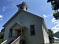
Tuckasegee Wesleyan Church (around 1900)
-
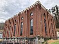
Lake Glenville Powerhouse (1941) is an Art Deco building near NC 107
