
Cullowhee, North Carolina facts for kids
Quick facts for kids
Cullowhee, North Carolina
|
|
|---|---|

Cullowhee, the Valley of the Lilies
|
|

Location of Cullowhee, North Carolina
|
|
| Country | United States |
| State | North Carolina |
| County | Jackson |
| Area | |
| • Total | 3.81 sq mi (9.86 km2) |
| • Land | 3.81 sq mi (9.86 km2) |
| • Water | 0.00 sq mi (0.00 km2) |
| Elevation | 2,156 ft (657 m) |
| Population
(2020)
|
|
| • Total | 7,682 |
| • Density | 2,017.33/sq mi (778.91/km2) |
| Time zone | UTC-5 (Eastern (EST)) |
| • Summer (DST) | UTC-4 (EDT) |
| ZIP code |
28723
|
| Area code(s) | 828 |
| FIPS code | 37-15880 |
| GNIS feature ID | 2402390 |
Cullowhee (say it: /ˈkʌləhwiː/) is a small community in Jackson County, North Carolina, USA. It's located right by the Tuckasegee River. In 2020, about 7,682 people lived here. This was more than the 6,228 people who lived here in 2010.
Cullowhee is famous for being home to Western Carolina University. This university is part of the University of North Carolina system. It started as a high school and a school for teachers. Now, it has about 12,000 students. The university plays a big role in the community. The Jackson County Airport is also very close by.
The area where Cullowhee is today used to be a historic Cherokee town. This town was built around a special earth mound called Cullowhee Mound. For a long time, people thought the name "Cullowhee" meant "Valley of the Lilies." But it actually comes from a Cherokee phrase, joolth-cullah-wee. This means "Judacullah's Place." Judacullah was a giant warrior and hunter. The Cherokee people believe he lived in this area. He is a very important figure in their culture and beliefs.
Contents
Geography of Cullowhee
Cullowhee is in the middle of Jackson County. It sits in the valley of the Tuckasegee River. North Carolina Highway 107 goes through the community. This highway leads north about 6 miles (10 km) to Sylva. Sylva is the main town in Jackson County. The highway also goes southeast about 7 miles (11 km) to Tuckasegee.
The Cullowhee area covers about 3.5 square miles (9.1 km2) of land. There is no water area within its official boundaries.
Cullowhee's Weather
Cullowhee usually has mild winters. In the summer, temperatures can get quite warm. They can reach into the 90s Fahrenheit (over 32 degrees Celsius).
| Climate data for Cullowhee, North Carolina (1991–2020 normals, extremes 1909–present) | |||||||||||||
|---|---|---|---|---|---|---|---|---|---|---|---|---|---|
| Month | Jan | Feb | Mar | Apr | May | Jun | Jul | Aug | Sep | Oct | Nov | Dec | Year |
| Record high °F (°C) | 79 (26) |
79 (26) |
87 (31) |
91 (33) |
92 (33) |
98 (37) |
99 (37) |
98 (37) |
97 (36) |
97 (36) |
82 (28) |
80 (27) |
99 (37) |
| Mean daily maximum °F (°C) | 48.5 (9.2) |
52.8 (11.6) |
60.8 (16.0) |
70.3 (21.3) |
77.0 (25.0) |
82.4 (28.0) |
85.3 (29.6) |
84.3 (29.1) |
79.1 (26.2) |
70.0 (21.1) |
59.9 (15.5) |
51.1 (10.6) |
68.5 (20.3) |
| Daily mean °F (°C) | 37.1 (2.8) |
40.5 (4.7) |
47.4 (8.6) |
55.9 (13.3) |
63.8 (17.7) |
70.5 (21.4) |
74.0 (23.3) |
73.0 (22.8) |
67.5 (19.7) |
56.9 (13.8) |
46.4 (8.0) |
39.9 (4.4) |
56.1 (13.4) |
| Mean daily minimum °F (°C) | 25.6 (−3.6) |
28.2 (−2.1) |
34.0 (1.1) |
41.6 (5.3) |
50.5 (10.3) |
58.6 (14.8) |
62.7 (17.1) |
61.7 (16.5) |
55.8 (13.2) |
43.8 (6.6) |
33.0 (0.6) |
28.7 (−1.8) |
43.7 (6.5) |
| Record low °F (°C) | −19 (−28) |
−14 (−26) |
−1 (−18) |
17 (−8) |
26 (−3) |
33 (1) |
43 (6) |
38 (3) |
27 (−3) |
14 (−10) |
4 (−16) |
−11 (−24) |
−19 (−28) |
| Average precipitation inches (mm) | 4.85 (123) |
4.56 (116) |
4.64 (118) |
4.72 (120) |
4.34 (110) |
5.12 (130) |
5.01 (127) |
4.30 (109) |
4.31 (109) |
3.22 (82) |
4.04 (103) |
5.07 (129) |
54.18 (1,376) |
| Average snowfall inches (cm) | 1.3 (3.3) |
0.7 (1.8) |
0.7 (1.8) |
0.0 (0.0) |
0.0 (0.0) |
0.0 (0.0) |
0.0 (0.0) |
0.0 (0.0) |
0.0 (0.0) |
0.1 (0.25) |
0.0 (0.0) |
1.5 (3.8) |
4.3 (11) |
| Average precipitation days (≥ 0.01 in) | 11.1 | 11.0 | 12.1 | 10.9 | 12.0 | 13.9 | 14.0 | 12.6 | 9.7 | 7.7 | 9.2 | 11.3 | 135.5 |
| Average snowy days (≥ 0.1 in) | 0.8 | 0.5 | 0.3 | 0.0 | 0.0 | 0.0 | 0.0 | 0.0 | 0.0 | 0.0 | 0.0 | 1.0 | 2.6 |
| Source: NOAA | |||||||||||||
History of Cullowhee
Cullowhee grew up in a mountain river valley, next to a creek. It was once a historic Cherokee village. This village was built around a large earth mound. Experts believe this mound was built around 1000 CE. It was made by people from the South Appalachian Mississippian culture. Digs at Cullowhee Mound show that people have lived in this area since 3000 BCE. The Cherokee built large council houses on top of these mounds. These were important places for the community to meet.
In the early 1800s, the Cherokee people had to give up their land here. Then, European-American settlers moved in. They built their homes where the Cherokee village used to be. Cullowhee became one of the first European-American settlements in Jackson County. People say the first school in the area opened here in 1830. It was a one-room school. The settlers used the flat river areas for farming. They cleared more land than the Cherokee had.
In 1883, Roland A. Painter started the Painter Post Office. It was in his store on Old Cullowhee Road. Other businesses also opened nearby. In 1908, the post office was renamed "Cullowhee."

In 1889, Robert Lee Madison started Cullowhee High School. This school later grew into a "normal school." A normal school trains teachers. Over time, it became a four-year college. Eventually, it grew into today's Western Carolina University.
The school stopped being called a high school in 1923. A new brick building opened for grades 1–11. In 1940, a huge flood hit the area. It badly damaged the business district. Almost all the buildings on the north side of the river were destroyed. Buildings on the south side survived, but they were very wet. The flood waters rose 21 feet (6.4 m) above Cullowhee Dam. This was the highest flood ever recorded there.
After the flood, new dams were built to control flooding. These dams are on the East and West forks of the Tuckasegee River. When the town rebuilt, new buildings were put on higher ground. This was around Old Cullowhee Road. The area closer to the river was left empty.
Businesses on Old Cullowhee Road slowed down in the late 1900s. This happened when Highway N.C. 107 was moved in the late 1970s and early 1980s. But since the 1960s, Western Carolina University has grown a lot. This growth has helped the area around the campus. Today, the university has 12,000 students. It offers many sports and cultural events. Cullowhee has also become a popular place for people to retire. Many new homes have been built for them.
The university wants to create a new "Town Center." This would be on some of its land. Local business people are also working to improve Old Cullowhee Road. Many new homes are being built or planned in the area.
Cullowhee has had a public school since 1923. It has been in four different buildings. The school has always worked closely with the college (now university) to train teachers. It was first called Cullowhee Training School (until 1939). Then came McKee Training School (until 1964). Both of these were on the university campus. From 1964 to 1994, it was called Cordelia Camp Laboratory School. This school was still part of the university's education programs. Today, the Cullowhee Valley School is the newest building. It serves students from kindergarten to 8th grade. High school students go to Smoky Mountain High School in nearby Sylva.
The oldest European-American building still standing is St. David's in the Valley church. It was built in 1880. The Joyner Building and Judaculla Rock are both listed on the National Register of Historic Places. This means they are important historical sites.
A report by the Walton Family Foundation ranked Cullowhee's area (Jackson County) as number 13 in the United States. This is because it's a popular place for tourists. It also has good job growth, rising wages, and new businesses.
Population of Cullowhee
| Historical population | |||
|---|---|---|---|
| Census | Pop. | %± | |
| 2010 | 6,228 | — | |
| 2020 | 7,682 | 23.3% | |
| U.S. Decennial Census | |||
In 2020, there were 7,682 people living in Cullowhee. There were 1,269 households and 165 families.
Who Lives in Cullowhee?
| Group | Number | Percentage |
|---|---|---|
| White (not Hispanic) | 5,996 | 78.05% |
| Black or African American (not Hispanic) | 391 | 5.09% |
| Native American | 67 | 0.87% |
| Asian | 111 | 1.44% |
| Pacific Islander | 2 | 0.03% |
| Other/Mixed | 328 | 4.27% |
| Hispanic or Latino | 787 | 10.24% |
Education in Cullowhee
Western Carolina University is a big part of the University of North Carolina system. It is the fifth-oldest school in the UNC system. It started in 1889 with only a few hundred students. It was in a small, one-story wooden building. Today, it has more than 12,000 students. The university offers about 220 different majors for college students. It also has over 45 programs for graduate students. The campus is huge, covering about 600 acres (240 ha). It takes up a large part of the Cullowhee Valley.
The university has a special Cherokee Studies program. This program includes learning the Cherokee language. It works with the Eastern Band of Cherokee Indians. This is the only Native American tribe in the state that the U.S. government officially recognizes. The program is based in Cherokee, North Carolina, at Qualla Boundary. Teachers from the university also work with the Cherokee tribe. They survey old town sites and earth mounds. They create a database of these important places. They also do studies about history and people. They work with the Cherokee people to learn from their oral histories. More than 50 mound sites have been found in the western counties of North Carolina.
The public school for kids in kindergarten through 8th grade is Cullowhee Valley School. It opened in 1994. It replaced an older building that was on the university campus. Since 1988, Cullowhee no longer has its own high school. Students of high school age go to Smoky Mountain High School in nearby Sylva.
Future Plans for Cullowhee
Forest Hills is a village just south of Cullowhee. It is thinking about a plan from Western Carolina University. The university wants Cullowhee to become an official town or city. This would include adding areas along Old Cullowhee Road and NC 107. The university's plan suggests building a traditional downtown area. This would have mixed-use buildings (shops and homes). It would also have a city hall, homes, and places where people can walk easily. There would be a supermarket, and trails and parks along the river. The elementary school, post office, and other town services could move here. A "town center" is planned on about 35 acres (14 ha) of land owned by the university. This area is a target for new development.
This plan is causing some debate. Some worry it might take business away from Old Cullowhee Road. It might also bring in big chain stores instead of local small businesses. The "town center" could have up to 270,000 square feet (25,000 m2) of shops, homes, and offices. It would also have parking for 871 cars. A parking garage with 320 spaces is planned on 22 acres of university land. This land currently has the Cordelia Camp Outreach Center, sports fields, and parking lots. The plan would also include the business area on Old Cullowhee Road (S.R. 1002). This is near the old campus entrance.
Another idea for redevelopment comes from the Cullowhee Revitalization Endeavor (CuRvE). This group is made up of local business people and activists. They also want to bring life back to the old business center. CuRvE wants to make Cullowhee a "unique and highly attractive area." They imagine a mix of homes and businesses along the rivers and streams. CuRvE believes their plan has more support from the community. This is because it would help small businesses. It would also use the beautiful setting of Old Cullowhee Road along the mountain river.
Gallery
-
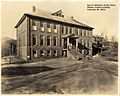
The Joyner Building was the main Western Carolina University building from 1916 until 1939.
-
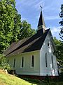
St. David's-in-The-Valley Church (1886)
-
Former McKee Training School (1939)
-
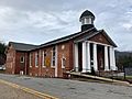
Cullowhee Baptist Church
-

The Ramsey Center hosts many local events, as well as many of the major Western Carolina University sports programs.
-
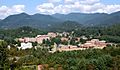
Western Carolina University in 2007, before work on the Quad, new dormitories, and Courtyard Cafeteria started
-
Cordelia Camp Building (ex-Cordelia Camp Laboratory School), Western Carolina University (1964)
-
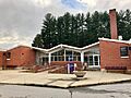
Cullowhee Valley K-8 School, located along NC 107
-
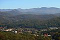
Cullowhee as seen from the Jackson County Airport on Berry Ridge above Little Savannah Road
-

A solar eclipse passed over Cullowhee on August 21, 2017. This is an image as viewed from the campus of WCU.


.jpg)
.jpg)


.jpg)


Famous People from Cullowhee
- Cal Raleigh, a professional baseball player for the Seattle Mariners
- Nick Searcy, an actor
See also
 In Spanish: Cullowhee para niños
