Addie, North Carolina facts for kids
Quick facts for kids
Addie, North Carolina
|
|
|---|---|
| Country | United States |
| State | North Carolina |
| County | Jackson |
| Elevation | 2,277 ft (694 m) |
| Time zone | UTC-5 (Eastern (EST)) |
| • Summer (DST) | UTC-4 (EDT) |
| Area code(s) | 828 |
| GNIS feature ID | 1018771 |
Addie is a small, unincorporated community in Jackson County, North Carolina. An unincorporated community is a place where people live and work, but it's not officially a town or city with its own local government.
Addie is located along U.S. Route 74, which is a major highway. It sits west of a place called Willets-Ochre Hill and east of the town of Sylva.
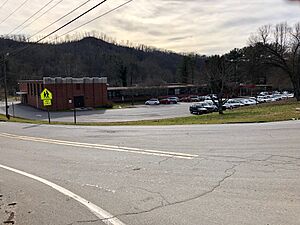
Important places in Addie include the Jackson County School of Alternatives, also known as the HUB. Scotts Creek Elementary School is also found here. A company called T&S Hardwoods runs a lumber yard in Addie. This lumber yard is right next to the railroad tracks that go through the area.
The community got its name from Nancy Adelaide Calhoun. Her father, John Philemon Calhoun, was the local postmaster at the time.
History
Addie started in the 1880s. This was when a work camp was set up nearby. The camp was for people building the Murphy Branch of the Western North Carolina Railroad. The community was named around this time.
Later, this location became a depot for the Southern Railway. A depot is a station where trains stop. It also served as a place where train crews would change shifts.
 | Delilah Pierce |
 | Gordon Parks |
 | Augusta Savage |
 | Charles Ethan Porter |


