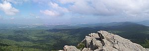
Humpback Rock facts for kids
Quick facts for kids Humpback Rock |
|
|---|---|
| Highest point | |
| Elevation | 3,080 ft (940 m) |
| Geography | |
| Location | Augusta / Nelson counties, Virginia, U.S. |
| Parent range | Blue Ridge Mountains |
| Topo map | USGS Sherando |
| Geology | |
| Age of rock | Precambrian |
| Mountain type | Granite |
| Climbing | |
| Easiest route | Hike |
Humpback Rock is a huge rock sticking out from Humpback Mountain. It's located in the Blue Ridge Mountains in Virginia, United States. This rock formation is special because it looks like a "hump" on the side of the mountain.
Humpback Rock is about 3,080 feet (939 meters) high. It stands out from other mountains in the Blue Ridge because its top is rocky and open. Many other nearby peaks are covered in thick trees. This spot is popular for visitors and has a well-kept trail and a visitor center. It's found about six miles (10 km) south of the northern entrance to the Blue Ridge Parkway.
Contents
How Humpback Rock Was Formed
Humpback Rock and the mountains around it are made of very old rock. About a billion years ago, deep under the ocean, a huge amount of granite formed. Later, about 400 million years after that, hot, melted rock called basalt flowed out. This basalt cooled and turned into a layer of green-colored rock called greenstone on top of the granite.
Over millions of years, sand and other tiny bits of rock settled on the ocean floor. This created layers of quartzite and sandstone. Even later, tiny sea creatures left behind their shells and skeletons. These formed a layer of limestone.
Then, about 700 million years after the granite first formed, the ocean started to close up. This caused huge pieces of granite and other rocks to slowly push westward. They eventually pushed up over the limestone layers. This incredible process created Humpback Rock and the Blue Ridge Mountains we see today.
Exploring Humpback Gap
From the 1850s until the early 1900s, people used a road called Howardsville Turnpike. Wagon drivers used it to carry goods between Howardsville and the Shenandoah Valley. They often camped at a spot called Humpback Gap.
Near Humpback Gap, there's a large area called the Humpback Rocks Recreation Area. You can see an old rock fence there. It's said to have been built by enslaved people who worked for a plantation owner. Just a bit further, at milepost 5.8 on the Blue Ridge Parkway, you'll find the Humpback Rocks themselves.
Early European settlers in the Appalachian Mountains used what they found in nature to live. Trees like hickory, chestnut, and oak gave them nuts for food. They used logs for building houses and a substance called tannin for treating animal hides. Rocks were used for house foundations, chimneys, and stone fences to keep their animals from wandering off. Many self-sufficient farms grew in the Humpback Mountain area.
Today, you can visit a collection of old farm buildings from the 1800s. The Mountain Farm trail lets you explore the cabin and other small buildings. There's also a visitor center with new exhibits, a picnic area, and more trails to explore.
Hiking Humpback Rocks
The Main Trail
Hiking to Humpback Rocks is a fairly quick adventure. The main trail is a loop about 2.0 miles (3.2 km) long. It usually takes about 45 minutes to hike up to the peak. You'll climb about 740 feet (226 meters) in elevation. The hike down is quicker, taking about 20-25 minutes. This makes it one of the shorter hikes along the Blue Ridge Parkway.
When you reach the top, you get an amazing 360-degree view! To the north, you can see into the southern part of Shenandoah National Park. To the east, you'll see a mix of farms. To the southwest, there are thick woods and mountain ridges of the George Washington National Forest.
You can keep following the trail for another 0.5 miles (0.8 km). This part of the trail goes along the top of a cliff, giving you more views to the south and east. Then, it goes down for about 1.2 miles (1.9 km) to a blue-marked trail. This blue trail leads 0.3 miles (0.5 km) into the Humpback Rocks Picnic Area. The total distance between Humpback Gap and the Humpback Rocks Picnic Area is 3.6 miles (5.8 km). You can find a map of the hike on the Blue Ridge Parkway website. If you keep going past Humpback Rocks, the very top of Humpback Mountain is just a few minutes further. The famous Appalachian Trail also passes nearby, about a short distance north at milepost 6.
Getting There
The Humpback Rocks Visitors Center is located at mile marker 5.8 on the Blue Ridge Parkway. It's about six miles (9.7 km) south of the Rockfish Gap Interchange. This interchange is where I-64 and US 250 meet.
The easiest way to get there is by taking either I-64 or US 250. Then, head south on the Blue Ridge Parkway for 5.8 miles (9.3 km) to reach the Visitors Center. If you drive another 0.2 miles (0.3 km), you'll find the Humpback Gap parking area on your left.
You can also find a map of the Blue Ridge Parkway that includes Humpback Rocks on the Texas Library webpage.
Camping Nearby
If you want to camp, there are places available nearby. The Sherando Lake Recreation Area is in the George Washington National Forest. It's located off the Blue Ridge Parkway, a few miles south of Humpback Rocks. For hikers on the Appalachian Trail coming from the north, there's a shelter called the Paul C. Wolfe shelter.
Appalachian Trail Access
You can also get onto the Appalachian Trail from the Humpback Gap parking area. If you're hiking south on the Appalachian Trail, you can reach it by continuing south on the Humpback Rocks trail. If you're hiking north, you can take a one-mile (1.6 km) blue-marked path at the northern end of the parking lot. Another option is a one-mile (1.6 km) white-marked path just off the Howardsville Turnpike.


