
Mount Marcy facts for kids
Quick facts for kids Mount Marcy |
|
|---|---|

Mount Marcy (photo taken from Mount Haystack, looking across Panther Gorge)
|
|
| Highest point | |
| Elevation | 5,343 ft (1,629 m) |
| Prominence | 4,914 ft (1,498 m) |
| Listing |
|
| Naming | |
| Etymology | Named for William L. Marcy |
| Native name | Error {{native name}}: an IETF language tag as parameter {{{1}}} is required (help) |
| Geography | |

Mount Marcy
Location in New York Adirondack Park

Mount Marcy
Location in the United States
|
|
| Parent range | Adirondack Mountains |
| Topo map | USGS Mount Marcy |
| Climbing | |
| First ascent | August 8, 1837 by Ebenezer Emmons and party |
| Easiest route | Hike (Van Hoevenberg trail) |
Mount Marcy is the highest mountain in New York State. It stands tall at 5,344 feet (1,629 m) (about 1.6 kilometers) above sea level. You can find it in Essex County, right in the middle of the Adirondack High Peaks area.
This mountain is super popular with hikers, especially in summer. People love its amazing views from the top. A small lake called Lake Tear of the Clouds is near Mount Marcy. It's often called the highest starting point of the famous Hudson River.
Contents
Mountain History
Before European settlers arrived, Native Americans had their own names for the mountain. In the Mohawk language, it was called Tewawe’éstha, which means "it pierces." In the Algonquin language, it was known as Tahawus, meaning "cloud-splitter."
How Mount Marcy Got Its Name
The mountain is named after William L. Marcy. He was the Governor of New York in the 1800s. He approved a special survey to explore this area.
First Climb to the Top
The first recorded climb to the summit happened on August 5, 1837. A large group, led by Ebenezer Emmons, made the journey. They were looking for the source of the Hudson River. Today, many trails lead to the top. Even though it's a long hike, most people can go up and down in one day.
A President's Journey
On September 14, 1901, Theodore Roosevelt was at his hunting camp near Mount Marcy. He had just climbed the mountain. At that time, he was the Vice President of the United States. He received urgent news that President William McKinley was very ill.
Roosevelt and his group quickly hiked about 10 miles (16 km) down the mountain. They then took a horse-drawn coach to the nearest train station. Along the way, Roosevelt learned that President McKinley had passed away. He then took the train to Buffalo to become the new President. The path he took from his camp to the train station is now called the Roosevelt-Marcy Trail.
Hiking Trails to the Summit
Mount Marcy is the tallest of the Adirondack High Peaks. Most of the mountain is covered in trees. However, the last few hundred feet are above the tree line, meaning there are no trees. This part of the peak has rocky areas, small plants, and shrubs. At the very top, you'll find plaques that celebrate the mountain and its first recorded climb.
Popular Hiking Routes
The shortest and most used path to the summit is the Van Hoevenberg Trail. It starts near Heart Lake at the Adirondak Loj. From there, it's about 7.4 miles (11.2 km) to the top. This means a round trip is about 14.8 miles (22.4 km), which can be done in a day. Parts of this trail are also good for skiing and snowboarding in winter.
Another route is the Johns Brook Trail. This trail starts from the Garden parking area in Keene Valley. It's an 18-mile (28.8 km) round trip. Many hikers choose to break this hike into two days by staying at Johns Brook Lodge.
You can also approach the mountain from the south. These longer routes start from Upper Works or Elk Lake.
Views from the Top
When the weather is clear, the views from Mount Marcy's summit are incredible! You can see far into Quebec's St. Lawrence valley, including some distant hills. You can also spot Burlington and Lake Champlain, with the Green Mountains in the background. The view stretches far beyond the southern Adirondacks too.
Mountain Weather
Mount Marcy has a cool and humid climate, especially in summer. Even on warm summer days, the air can feel comfortable. However, sometimes it can get quite warm. The highest temperature recorded since 1981 was 85.7 °F (29.8 °C) (about 29.8 °C (85.6 °F)) in August 1988.
Winters on Mount Marcy are very cold. The average lowest temperature in winter is around −32.4 °F (−35.8 °C) (about −35.8 °C (−32.4 °F)). The coldest temperature ever recorded since 1981 was −36.0 °F (−37.8 °C) (about −37.8 °C (−36.0 °F)) in January 1994. It can also get very windy, making it feel even colder. The mountain gets a lot of snow, usually around 200 inches (508 cm) (about 5 meters) each year from September to May.
| Climate data for Mount Marcy, 1981-2010 normals (elevation 4,537 ft (1,383 m)), 1981-2018 extremes (elevation 3,825 ft (1,166 m)) | |||||||||||||
|---|---|---|---|---|---|---|---|---|---|---|---|---|---|
| Month | Jan | Feb | Mar | Apr | May | Jun | Jul | Aug | Sep | Oct | Nov | Dec | Year |
| Record high °F (°C) | 54.3 (12.4) |
55.0 (12.8) |
70.5 (21.4) |
80.8 (27.1) |
82.8 (28.2) |
84.2 (29.0) |
85.4 (29.7) |
85.7 (29.8) |
84.6 (29.2) |
74.6 (23.7) |
62.9 (17.2) |
57.1 (13.9) |
85.7 (29.8) |
| Mean daily maximum °F (°C) | 17.0 (−8.3) |
20.0 (−6.7) |
29.6 (−1.3) |
44.6 (7.0) |
56.2 (13.4) |
64.7 (18.2) |
68.4 (20.2) |
67.3 (19.6) |
60.8 (16.0) |
49.3 (9.6) |
34.1 (1.2) |
21.8 (−5.7) |
44.6 (7.0) |
| Daily mean °F (°C) | 9.2 (−12.7) |
12.3 (−10.9) |
20.5 (−6.4) |
34.0 (1.1) |
46.0 (7.8) |
54.7 (12.6) |
58.9 (14.9) |
57.8 (14.3) |
51.2 (10.7) |
39.5 (4.2) |
26.7 (−2.9) |
14.8 (−9.6) |
35.6 (2.0) |
| Mean daily minimum °F (°C) | 1.4 (−17.0) |
4.5 (−15.3) |
11.5 (−11.4) |
23.4 (−4.8) |
35.8 (2.1) |
44.7 (7.1) |
49.4 (9.7) |
48.3 (9.1) |
41.6 (5.3) |
29.6 (−1.3) |
19.3 (−7.1) |
7.9 (−13.4) |
26.6 (−3.0) |
| Record low °F (°C) | −36.0 (−37.8) |
−32.0 (−35.6) |
−28.7 (−33.7) |
−3.5 (−19.7) |
19.0 (−7.2) |
22.4 (−5.3) |
31.9 (−0.1) |
29.6 (−1.3) |
20.3 (−6.5) |
10.5 (−11.9) |
−14.4 (−25.8) |
−29.7 (−34.3) |
−36.0 (−37.8) |
| Average precipitation inches (mm) | 4.76 (121) |
3.91 (99) |
4.87 (124) |
5.50 (140) |
6.41 (163) |
6.39 (162) |
6.91 (176) |
6.97 (177) |
6.76 (172) |
6.96 (177) |
6.43 (163) |
5.34 (136) |
71.21 (1,809) |
| Average relative humidity (%) | 85.8 | 81.8 | 69.5 | 61.6 | 65.5 | 74.3 | 77.8 | 78.6 | 79.9 | 74.0 | 78.5 | 88.0 | 76.3 |
| Average dew point °F (°C) | 5.8 (−14.6) |
7.8 (−13.4) |
12.1 (−11.1) |
22.2 (−5.4) |
35.1 (1.7) |
46.7 (8.2) |
52.0 (11.1) |
51.2 (10.7) |
45.2 (7.3) |
31.9 (−0.1) |
20.9 (−6.2) |
11.9 (−11.2) |
28.7 (−1.8) |
| Source: PRISM | |||||||||||||
Mountain Plants and Animals
Mount Marcy is home to a type of forest called Northeastern Spruce/Fir forest. These are mostly conifer trees, which stay green all year. The mountain is in a very cold plant hardiness zone, meaning only tough plants can grow there.
The spring flowers usually bloom around May 30th. The beautiful fall colors, when leaves change, typically peak around September 19th.
Gallery
-
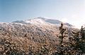
Summit of Mount Marcy seen from near Mt.Skylight.
-
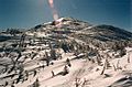
Mount Marcy summit
-
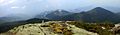
Mount Marcy Summit Panorama
-
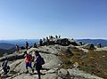
The summit may be rather crowded on summer holiday weekends


Images for kids
-
Badge award for Mount Marcy climb (early 1970s)

