
Mount Arvon facts for kids
Quick facts for kids Mount Arvon |
|
|---|---|

Mount Arvon summit sign and log book
|
|
| Highest point | |
| Elevation | 1,979 ft (603 m) NGVD 29 |
| Prominence | 948 ft (289 m) |
| Listing | U.S. state high point 38th |
| Geography | |

Mount Arvon
Location in Michigan
|
|
| Parent range | Huron Mountains |
| Topo map | USGS Skanee South |
Mount Arvon is the highest natural point in the U.S. state of Michigan. It stands at about 1,979 feet (603 meters) tall. This mountain is located in Baraga County, Michigan, within L'Anse Township. Mount Arvon is part of the Huron Mountains range. It is found about 8 miles (13 km) south of Lake Superior, which has an elevation of 591 feet (180 meters). Among all the highest points in each U.S. state, Mount Arvon is ranked 38th.

Michigan's Highest Point
For many years, another mountain called Mount Curwood was thought to be Michigan's highest point. However, in 1982, new technology was used to measure the mountains more accurately. This survey showed that Mount Arvon is actually 1 foot (0.3 meters) taller than Mount Curwood. This made Mount Arvon the official highest point in Michigan.
Getting to Mount Arvon
Mount Arvon is located about 12 miles (19 km) east of the town of L'Anse, Michigan. However, the drive to the mountain is much longer. It takes about 26 miles (42 km) to reach the summit by car. This is because many parts of the road are winding logging roads. These roads are often used by trucks that carry timber.

View from Mount Arvon to Lake Superior, May 2014
|
Public Access
The land where Mount Arvon is located belongs to the MeadWestvaco paper company. Even though it is private property, the company allows the public to visit the mountain. This means people can still enjoy the views and experience Michigan's highest point.
Images for kids
-
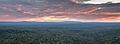
Mount Arvon viewed from the north.
-
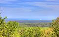
View from Mount Arvon to Lake Superior, May 2014.
