
Mount Mansfield facts for kids
Quick facts for kids Mount Mansfield |
|
|---|---|

Mount Mansfield, September 2004
|
|
| Highest point | |
| Elevation | 4,393 ft (1,339 m) NAVD 88 |
| Prominence | 3,633 ft (1,107 m) |
| Listing | U.S. state high point 26th New England Fifty Finest 3rd New England 4000-footers |
| Geography | |

Mount Mansfield
Location in Vermont
|
|
| Parent range | Green Mountains |
| Topo map | USGS Mount Mansfield |
| Climbing | |
| Easiest route | Hike |
| Designated: | 1980 |
Mount Mansfield is the tallest mountain in Vermont, reaching 4,395 feet (1,340 m) above sea level. Its very top, called the summit, is in the town of Underhill. Other parts of the mountain stretch into Stowe and Cambridge.
This mountain looks like a giant human face when you see it from the east or west! You can clearly spot a forehead, nose, lips, chin, and even an Adam's apple. The chin is actually the highest point of the mountain.
Mount Mansfield is one of only three places in Vermont where you can find true alpine tundra. This special type of land, with small, tough plants, has survived since the Ice Ages. While a few acres exist on nearby Camel's Hump and Mount Abraham, Mount Mansfield's summit still has about 200 acres (81 ha) of it. Because of this unique environment, the Mount Mansfield Natural Area was named a National Natural Landmark in 1980.
The mountain is part of the Mount Mansfield State Forest and is used for many fun activities. "The Nose" section has towers for radio and TV stations. There are also many hiking trails, including the famous Long Trail, which goes along the main ridge. In winter, the eastern side of the mountain is a popular spot for skiing at the Stowe Mountain Resort. A fun way to explore is to take the toll road from the Stowe Base Lodge up to "The Nose" and then hike along the ridge to "The Chin."
Contents
What's in a Name? The Story of Mount Mansfield's Name
Before the mid-1700s, the Abenaki people, who lived in this area, called the mountain Mozodepowadso. This name means "Moosehead Mountain."
Later, the mountain and a nearby town were named Mansfield. Some people thought it was named after Mansfield, Connecticut. However, that town wasn't called Mansfield until 1774. This was 11 years after Benning Wentworth, the governor of New Hampshire, named the Vermont town "Mansfield."
It's more likely that the mountain and town were named after Lord Mansfield. He was an important judge in England. In 1752, Lord Mansfield helped decide that the land where Vermont is now belonged to New Hampshire, not New York. Governor Wentworth likely named the town and mountain after him to say thank you. The original town of Mansfield was mostly mountain. Over time, it was divided between the towns of Underhill and Stowe. This is why the "Chin" of the mountain is in Underhill, and the "Nose" is in Stowe.
Exploring Mount Mansfield's Shape
The ridge that forms the "head" of the "man" on Mount Mansfield runs from north to south. The "Adam's apple" is at the northern end of this ridge, and the "forehead" is towards the south. If you look at the mountain from the north, this ridge looks like a triangle.
On the northeastern side of the mountain, there are tall cliffs. At the bottom of these cliffs, you can find a network of talus caves. These are caves formed by large rocks that have fallen and created spaces. There are also cliffs on the eastern side of the Notch Road, facing the other cliffs.
Skiing Adventures on Mount Mansfield
Mount Mansfield is a fantastic place for skiing! The Stowe Mountain Resort is located on its eastern side.
Some of the most famous and challenging trails are known as the "Front Four": Goat, Starr, National, and Liftline. These trails are very steep and have many natural obstacles like rocks and trees. They are not groomed much, which means they are best for expert skiers.
Besides downhill skiing, you can also enjoy cross-country ski trails around the base of the mountain. The Bruce Trail goes down the east side, and the Teardrop Trail goes down the west side. Another nearby place to ski is the Smugglers' Notch Resort.

Climate on the Mountain
Mount Mansfield has a cool climate, similar to places found in northern Canada or Alaska. Even though it's in Vermont, the high elevation makes it much colder.
Summers on the mountain are mild during the day and cool at night. Winters are long, very cold, and get a lot of snow. Winter usually lasts from November through April. On average, the mountain gets about 223 in (5.7 m) of snow each year. The most snow recorded in one day was 28 in (71 cm) on March 15, 2017. The deepest snow ever recorded was 149 in (3.8 m) on April 2, 1969. It has even snowed on the summit during every month of the year!
| Climate data for Mount Mansfield, Vermont | |||||||||||||
|---|---|---|---|---|---|---|---|---|---|---|---|---|---|
| Month | Jan | Feb | Mar | Apr | May | Jun | Jul | Aug | Sep | Oct | Nov | Dec | Year |
| Record high °F (°C) | 50 (10) |
51 (11) |
65 (18) |
74 (23) |
85 (29) |
84 (29) |
84 (29) |
79 (26) |
79 (26) |
71 (22) |
63 (17) |
60 (16) |
85 (29) |
| Mean daily maximum °F (°C) | 17.4 (−8.1) |
19.0 (−7.2) |
27.3 (−2.6) |
39.2 (4.0) |
53.3 (11.8) |
61.8 (16.6) |
65.4 (18.6) |
63.6 (17.6) |
56.4 (13.6) |
44.7 (7.1) |
32.9 (0.5) |
22.0 (−5.6) |
41.9 (5.5) |
| Daily mean °F (°C) | 9.4 (−12.6) |
11.1 (−11.6) |
19.9 (−6.7) |
31.8 (−0.1) |
45.1 (7.3) |
54.1 (12.3) |
58.2 (14.6) |
56.7 (13.7) |
49.4 (9.7) |
37.7 (3.2) |
26.4 (−3.1) |
14.5 (−9.7) |
34.5 (1.4) |
| Mean daily minimum °F (°C) | 1.4 (−17.0) |
3.2 (−16.0) |
12.5 (−10.8) |
24.4 (−4.2) |
36.9 (2.7) |
46.3 (7.9) |
51.0 (10.6) |
49.9 (9.9) |
42.4 (5.8) |
30.7 (−0.7) |
19.9 (−6.7) |
7.0 (−13.9) |
27.1 (−2.7) |
| Record low °F (°C) | −39 (−39) |
−36 (−38) |
−29 (−34) |
−13 (−25) |
5 (−15) |
20 (−7) |
24 (−4) |
25 (−4) |
16 (−9) |
−5 (−21) |
−15 (−26) |
−40 (−40) |
−40 (−40) |
| Average precipitation inches (mm) | 5.03 (128) |
4.38 (111) |
5.21 (132) |
5.62 (143) |
5.91 (150) |
6.85 (174) |
7.03 (179) |
7.35 (187) |
6.71 (170) |
6.42 (163) |
6.69 (170) |
6.08 (154) |
73.28 (1,861) |
| Average snowfall inches (cm) | 40.7 (103) |
37.0 (94) |
35.5 (90) |
21.3 (54) |
4.4 (11) |
0.1 (0.25) |
0.0 (0.0) |
0.0 (0.0) |
0.2 (0.51) |
9.6 (24) |
30.9 (78) |
42.9 (109) |
222.6 (563.76) |
| Average precipitation days (≥ 0.01 in) | 20 | 16 | 16 | 15 | 15 | 16 | 15 | 16 | 15 | 15 | 18 | 21 | 198 |
| Source: Western Regional Climate Center | |||||||||||||
Gallery
-
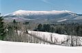
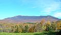
Western Slope of Mt. Mansfield from Underhill, Vermont.
-
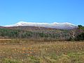
Mansfield from north of Stowe, Vermont.
-
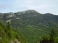
Mansfield from toll road.
-
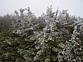
Rime ice in the Krummholz zone of Mansfield.
-
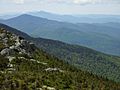
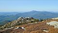
Looking south towards Camels Hump off the summit ridge.
-
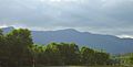
View from River Rd., Underhill, VT.
-
View from Stevensville Rd., Underhill, VT.
-
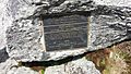
A plaque along the Long Trail between the "Chin" and the "Nose" of Mount Mansfield.


_within_Mount_Mansfield_State_Forest_in_Underhill,_Chittenden_County,_Vermont.jpg)
Images for kids
-
Northerly view of Mt. Mansfield from the summit of Camel's Hump.

