Underhill, Vermont facts for kids
Quick facts for kids
Underhill, Vermont
|
|
|---|---|

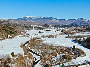
Aerial view of Underhill & Mt Mansfield, over the Browns River looking east towards Underhill Center (upper right)
|
|

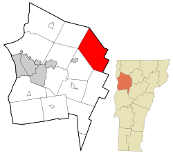
Location in Chittenden County and the state of Vermont.
|
|
| Country | United States |
| State | Vermont |
| County | Chittenden |
| Communities | Underhill Center Underhill Flats (part) North Underhill Stevensville |
| Area | |
| • Total | 51.4 sq mi (133.1 km2) |
| • Land | 51.4 sq mi (133.0 km2) |
| • Water | 0.0 sq mi (0.1 km2) |
| Elevation | 1,033 ft (315 m) |
| Population
(2020)
|
|
| • Total | 3,129 |
| • Density | 61/sq mi (23.5/km2) |
| Time zone | UTC−5 (Eastern (EST)) |
| • Summer (DST) | UTC−4 (EDT) |
| ZIP Code |
05489–05490
|
| Area code | 802 |
| FIPS code | 50-73975 |
| GNIS feature ID | 1462232 |
Underhill is a small town in Chittenden County, Vermont, in the United States. In 2020, about 3,129 people lived there.
The town of Underhill works with the nearby town of Jericho. They share a fire department called the Underhill-Jericho Fire Department.
Contents
Geography and Nature
Underhill covers about 51.4 square miles (133.1 square kilometers). Most of this area is land, with only a tiny bit of water.
The highest point in Vermont, Mount Mansfield, is located in Underhill. Its peak is about 4,393 feet (1,339 meters) above sea level.
The Browns River is the main waterway in Underhill. It starts as a stream on Mount Mansfield. As it flows southwest, other streams like Stevensville Brook and Clay Brook join it. Other smaller streams, such as Harvey Brook, Cranes Brook, and Mill Brook, also flow into the Browns River in the Underhill Center area.
Town Villages
Underhill has two main villages: Underhill Flats and Underhill Center. Both villages have their own post offices.
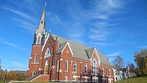
Underhill Flats is on the western side of the town. It is located along Vermont Route 15. This area is shared with the town of Jericho. It is also known as the Underhill Incorporated District. The United Church of Underhill and the main fire station are in the Underhill Flats area.
Underhill Center is on the eastern side of town. It is closer to the base of Mount Mansfield. Here you can find the Town Hall and other town offices. There is also a park with tennis courts, a basketball court, and a small swimming pond. Casey's Hill, a popular sledding spot, and the St. Thomas Catholic Church are also in Underhill Center.
Schools and Education
Underhill has a strong focus on education. In 2008, Underhill Independent Elementary School was the best in the county for reading. Underhill Central School was first in math.
In 2014, several communities, including Underhill, voted to create a new school district. This district is called the Mount Mansfield Modified Union School District, or MMMUSD. This district helps manage schools from Pre-K all the way through 12th grade. It includes elementary schools in Bolton, Jericho, Richmond, and Underhill. It also includes Browns River Middle, Camels Hump Middle, and Mt. Mansfield Union High Schools.
Population and People
| Historical population | |||
|---|---|---|---|
| Census | Pop. | %± | |
| 1790 | 65 | — | |
| 1800 | 212 | 226.2% | |
| 1810 | 490 | 131.1% | |
| 1820 | 633 | 29.2% | |
| 1830 | 1,052 | 66.2% | |
| 1840 | 1,441 | 37.0% | |
| 1850 | 1,599 | 11.0% | |
| 1860 | 1,637 | 2.4% | |
| 1870 | 1,655 | 1.1% | |
| 1880 | 1,439 | −13.1% | |
| 1890 | 1,301 | −9.6% | |
| 1900 | 1,140 | −12.4% | |
| 1910 | 1,004 | −11.9% | |
| 1920 | 896 | −10.8% | |
| 1930 | 781 | −12.8% | |
| 1940 | 760 | −2.7% | |
| 1950 | 698 | −8.2% | |
| 1960 | 730 | 4.6% | |
| 1970 | 1,198 | 64.1% | |
| 1980 | 2,172 | 81.3% | |
| 1990 | 2,799 | 28.9% | |
| 2000 | 2,980 | 6.5% | |
| 2010 | 3,016 | 1.2% | |
| 2020 | 3,129 | 3.7% | |
| U.S. Decennial Census | |||
In 2020, Underhill had 3,129 people living in 1,285 homes. Most people in Underhill are White.
About 65% of homes had married couples living together. The average home had about 2.45 people. The average family had about 2.89 people.
About a quarter of the population (24.3%) was under 18 years old. The median age in Underhill was 45.7 years. This means half the people were younger than 45.7, and half were older.
The average income for a household was about $87,227. For families, it was about $92,484.
Famous People from Underhill
Many interesting people have come from Underhill, including:
- Paul André Albert – A scientist who helped develop new ways to work with metals for IBM.
- Vernon A. Bullard – A lawyer who served as the United States Attorney for Vermont.
- Thomas Cale – A politician who represented the District of Alaska in Congress.
- Pat Dealy – A professional baseball player who played for several teams.
- Udney Hay – An important leader during the American Revolution and a Vermont politician.
- Bernard Joseph Leddy – A judge for the United States federal court system.
- Richard Phillips – A ship captain whose ship was taken by Somali pirates in 2009. His story was made into a movie called Captain Phillips.
See also
 In Spanish: Underhill (Vermont) para niños
 | Shirley Ann Jackson |
 | Garett Morgan |
 | J. Ernest Wilkins Jr. |
 | Elijah McCoy |


