
Mount Abraham (Vermont) facts for kids
Quick facts for kids Mount Abraham |
|
|---|---|

View of Mount Abraham from the west
|
|
| Highest point | |
| Elevation | 4,006 ft (1,221 m) |
| Prominence | 286 ft (87 m) |
| Listing | New England 4,000 footers |
| Geography | |

Mount Abraham
Location in Vermont
|
|
| Country | United States |
| State | Vermont |
| County | Addison |
| Town | Lincoln |
| Parent range | Presidential Range, Green Mountains |
| Topo map | USGS Lincoln Mountain Quad |
Mount Abraham is a cool mountain in the Green Mountains of Vermont, USA. People who live nearby often call it Mount Abe. Its highest point is in the town of Lincoln. But its eastern side reaches into the town of Warren.
This mountain is named after Abraham Lincoln. He was a very important former president of the United States. Mount Abraham is one of five tall peaks in Vermont's Presidential Range.
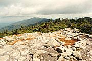
Mount Abraham stands at 4,006 feet (1,221 meters) tall. This makes it the highest point in Addison County. It is also the fifth highest peak in all of Vermont. Its top has a small area of special plants called alpine tundra. These plants can grow in very cold, windy places.
Contents
History of Mount Abraham
The town of Lincoln was started in 1780. It was named after Benjamin Lincoln. He was a hero from the American Revolutionary War. It's interesting because the town is not named after Abraham Lincoln. Even Lincoln Peak nearby is named after Benjamin Lincoln. All places in Addison County with "Lincoln" in their name were named before Abraham Lincoln was even born!
Different Names for the Mountain
Mount Abraham has had other names over time. It was sometimes called Lincoln Mountain. Another old name was Potato Hill. This name was used as far back as 1875. It might have been used at the same time as the current name for many years.
In 1897, a survey team wrote about the mountain. They said, "Potato Hill is sometimes called Mount Abraham Lincoln but it is better known by the former name." Over time, the name "Mount Abraham Lincoln" was shortened. It became "Mount Abraham." This name has been used since at least 1921. That's when the USGS started using it on their maps.
Plane Crash on Mount Abe
On June 28, 1973, a small plane crashed on Mount Abraham. The pilot was flying from New Hampshire to New York. He was trying to avoid some clouds. But he hit trees on the mountain's north side. Luckily, the pilot and two passengers survived the crash. Even today, you can still find parts of the plane on the mountain! It was a Cessna 182 Skylane aircraft.
Where the Water Flows
Mount Abraham is part of the watershed for Lake Champlain. A watershed is an area of land where all the water drains into one main river or lake. Water from Lake Champlain flows into the Richelieu River in Québec. Then it goes into the Saint Lawrence River. Finally, it reaches the Gulf of Saint Lawrence and the Atlantic Ocean.
Water from the southeast side of Mount Abraham flows into Lincoln Brook. This brook then joins the Mad River. The Mad River flows into the Winooski River, and then into Lake Champlain. The east side of the mountain drains into Bradley Brook. This brook also flows into the Mad River.
The southwest side of Mount Abraham feeds the start of the New Haven River. This river flows into Otter Creek. Otter Creek also empties into Lake Champlain. Water from the northwest side of the mountain flows into Beaver Meadow Brook. This brook is another part of the New Haven River system.
Hiking on Mount Abraham
Mount Abraham is a great place for hiking! The Long Trail goes right over the top of the mountain. This trail is a famous long-distance hiking path in Vermont.
Popular Hiking Routes
A popular day hike starts and ends in Lincoln. You can begin where the Long Trail crosses Lincoln Gap Road. From Lincoln Gap, the summit is about 2.6 miles (4.2 km) north on the Long Trail.
Another way to hike is using the Battell Trail. Its starting point is also in Lincoln. The Battell Trail is 2.0 miles (3.2 km) long. It ends at the Battell Shelter. From the shelter, the summit is 0.9 miles (1.4 km) north on the Long Trail.
Amazing Views from the Top
Mount Abraham offers some of the best views on the whole Long Trail. To the west, you can see the Champlain Valley. Beyond that, about 10 miles (16 km) away, are Mount Marcy and the Adirondack Mountains.
If you look in the other direction, to the east, you can see the White Mountains of New Hampshire. They are about 80 miles (129 km) away! To the south, you might spot Killington Peak. It's about 40 miles (64 km) from Mount Abraham.
-
Mount Ellen seen from Mount Abraham

