
Otter Creek (Vermont) facts for kids
Quick facts for kids Otter Creek |
|
|---|---|

Otter Creek Falls in Middlebury
|
|

Course of Otter Creek
|
|
| Country | United States |
| State | Vermont |
| Counties | Bennington, Rutland, Addison |
| Towns/Cities | Wallingford, Rutland, Brandon, Middlebury, Vergennes |
| Physical characteristics | |
| Main source | Peru, Vermont 2,500 ft (760 m) 43°16′49″N 72°58′32″W / 43.28024°N 72.97545°W |
| River mouth | Fort Cassin Point, Lake Champlain Ferrisburgh 29 m (95 ft) 44°13′32″N 73°19′29″W / 44.2256084°N 73.3248477°W |
| Length | 112 mi (180 km) |
Otter Creek is the longest river that is completely inside Vermont. It is about 112 mi (180 km) long. This river is the main waterway flowing through Rutland County and Addison County. The river ends by flowing into Lake Champlain.
People have lived along Otter Creek for at least 10,000 to 11,000 years. For these early people, the river was very important for trade and daily life. Later, when European settlers arrived, the river continued to be a key area. People used it for farming and for different industries during the 1700s and 1800s.
Contents
History of Otter Creek
Before Europeans settled in the area, Native American groups lived in the Otter Creek valley. Early settlers called the river the "Indian road." This shows how important it was for traveling between Abenaki, Algonquin, and Iroquois settlements. Old artifacts found by archaeologists suggest that people used the river for both trading and sometimes for war parties.
The French knew Otter Creek as "La Rivière aux Loutres," which means "River of Otters." This is where the English name "Otter Creek" comes from. In 1690, a captain named Abraham Schuyler was sent to watch for Native Americans about 7 miles (11 km) up the creek. This spot is now near the city of Vergennes.
In 1731, the French started building a fort called Fort Frederic at Crown Point. Before that, they started a new settlement called Addison. As more people learned about the rich land in the valley, more white settlers moved there during the 1700s.
Industrial Growth and Battles
Vergennes was one of the first industrial centers on the river. It is located at the first waterfalls, about 7 miles (11 km) from where the creek flows into Lake Champlain. A sawmill was built there in 1764.
In 1814, during the War of 1812, American forces quickly built a fleet of ships in Vergennes. These ships were very important in the Battle of Plattsburg.
Throughout the 1800s, towns used the fast-moving water of Otter Creek for factories. They built hydropower facilities in places like Rutland, Proctor, Brandon, Middlebury, Weybridge, and Vergennes. These facilities used the river's power to create energy for industries.
In 2011, Tropical Storm Irene caused Otter Creek to flood badly in downtown Rutland. This flood led to millions of dollars in damage.
Geography of Otter Creek

Otter Creek starts in the Green Mountain National Forest. It begins on the western side of Mt. Tabor in Peru, which is in Bennington County. From there, it flows southwest into Dorset and then turns north towards Emerald Lake.
The creek continues flowing north through several towns. These include Danby, Wallingford, Clarendon, and Rutland town. It also passes through the city of Rutland, and the towns of Proctor, Pittsford, and Brandon. All these towns are in Rutland County.
When Otter Creek enters Addison County, it often forms the border between different towns. It then flows through Middlebury, Weybridge, and Vergennes. Finally, it empties into Lake Champlain at Ferrisburgh.
Boating and Wildlife
The part of Otter Creek between its mouth at Fort Cassin Point (where the old Fort Cassin was) and Vergennes is deep enough for boats. Many people enjoy using motorboats, canoes, and kayaks here. Vergennes was an important shipyard during wars in the 1700s.
You might see osprey and bald eagles along the creek. Many nesting platforms have been built to help these birds.
Otter Creek has a waterfall in Middlebury. This spot was chosen in 1800 for Vermont's first college, Middlebury College. In Addison and Rutland counties, Otter Creek flows through large wetland areas. These include Cornwall Marsh, Little Otter Creek Marsh, and the Brandon Swamp.
Even though it's called a "creek," Otter Creek is quite large. Because of its name, smaller rivers sometimes flow into it. The source and mouth of Otter Creek are about 68 mi (109 km) apart in a straight line. However, the river actually flows about 44 mi (71 km) further because it twists and turns.
Ecology of Otter Creek
The Addison County Planning Commission says that Otter Creek has one of the widest and most natural floodplains in Vermont. Floodplains are flat areas next to a river that can flood. The alder swamps, marshes, and floodplains along the river help to soak up a lot of floodwater. These areas were never built on, which helps protect them.
However, the water quality near Lake Champlain and where the Middlebury River joins Otter Creek is often poor. There are high levels of E. coli bacteria in these areas. Otter Creek is also the second largest source of phosphorus pollution that flows into Lake Champlain.
Gallery
-
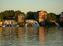
View of falls on Otter Creek from Vergennes town dock
-
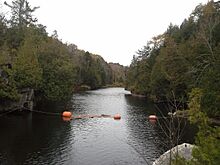
Otter Creek near Middlebury
-
Belden Falls of Otter Creek, in Wright Park in Middlebury
-
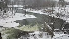
Otter Creek in Middlebury in the winter
-
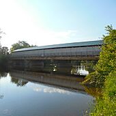
Pulp Mill Bridge over Otter Creek


