
Crown Point, New York facts for kids
Quick facts for kids
Crown Point, New York
|
|
|---|---|

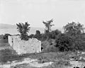
Ruins of the barracks at Fort Crown Point
|
|

Location in Essex County and the state of New York
|
|
| Country | United States |
| State | New York |
| County | Essex |
| Government | |
| • Type | Town Council |
| Area | |
| • Total | 81.85 sq mi (211.98 km2) |
| • Land | 76.12 sq mi (197.16 km2) |
| • Water | 5.72 sq mi (14.82 km2) |
| Elevation | 909 ft (277 m) |
| Population
(2010)
|
|
| • Total | 2,024 |
| • Estimate
(2016)
|
1,934 |
| • Density | 25.41/sq mi (9.81/km2) |
| Time zone | UTC-5 (Eastern (EST)) |
| • Summer (DST) | UTC-4 (EDT) |
| ZIP code |
12928
|
| Area code(s) | 518 |
| FIPS code | 36-031-19246 |
| GNIS feature ID | 0978879 |
Crown Point is a small town in Essex County, New York. It is located on the western shore of Lake Champlain. In 2010, about 2,024 people lived there. The town's name, Crown Point, comes from its original French name, Pointe à la Chevelure.
Crown Point is on the eastern edge of Essex County. It is about 43 miles (69 km) southwest of Burlington, Vermont. It is also about 107 miles (172 km) north of Albany, New York's capital.
Contents
History of Crown Point
Why was Crown Point important?
Crown Point was a very important place in history. This was because of its location on Lake Champlain. Two European forts were built here long ago. These forts were built even before the town itself was officially started.
French Fort Saint-Frédéric
The first fort was Fort Saint-Frédéric. The French built it in 1731. They came from their settlements in Quebec and Montreal to the north. The French and British both wanted to trade furs with Native Americans in this area.
British Fort Crown Point
During the Seven Years' War (also called the French and Indian War in North America), the British took control. The French destroyed their fort so the British couldn't use it. In 1759, the British built Fort Crown Point. It was the largest dirt fort in their colonies. After the war, France gave all its land east of the Mississippi River to Britain.

Crown Point during the American Revolution
The fort at Crown Point stayed important during the American Revolutionary War. It was on the west side of Lake Champlain. It was about 15 miles (24 km) north of Fort Ticonderoga. After the American attempt to invade Canada in 1776 failed, Fort Crown Point was the farthest north the Americans controlled. In 1777, General John Burgoyne used it to store supplies. This helped him during his attack on Fort Ticonderoga.
Founding of the Town
The town of Crown Point was officially started in 1788. This was after the American Revolution. Some parts of Crown Point were later used to form the town of Elizabethtown in 1798. New settlers from Vermont began to arrive around 1800.
Coldest Day in New York
Crown Point holds the record for the coldest temperature ever recorded in New York state in January. It was a very chilly -48 degrees Fahrenheit (-44 degrees Celsius)!
Geography of Crown Point
Where is Crown Point located?
Crown Point is located within the beautiful Adirondack Park. The town has a total area of about 81.85 square miles (212.0 square kilometers). Most of this area is land, with some water.
Lake Champlain and the Champlain Bridge
The eastern border of the town is Lake Champlain. This lake also forms the border with Vermont. The Champlain Bridge used to connect Crown Point to Vermont. This bridge was taken down in 2009 because it was unsafe. A new bridge opened in November 2011. It helps people travel between New York and Vermont.

Main Roads
Several main roads pass through Crown Point. These include New York State Route 9N, New York State Route 22, and New York State Route 185. Routes 9N and 22 run together through the town. Route 185 goes up the Crown Point peninsula.
People of Crown Point
| Historical population | |||
|---|---|---|---|
| Census | Pop. | %± | |
| 1820 | 1,522 | — | |
| 1830 | 2,041 | 34.1% | |
| 1840 | 2,212 | 8.4% | |
| 1850 | 2,378 | 7.5% | |
| 1860 | 2,252 | −5.3% | |
| 1870 | 2,449 | 8.7% | |
| 1880 | 4,287 | 75.1% | |
| 1890 | 3,135 | −26.9% | |
| 1900 | 2,112 | −32.6% | |
| 1910 | 1,690 | −20.0% | |
| 1920 | 1,413 | −16.4% | |
| 1930 | 1,468 | 3.9% | |
| 1940 | 1,661 | 13.1% | |
| 1950 | 1,707 | 2.8% | |
| 1960 | 1,685 | −1.3% | |
| 1970 | 1,857 | 10.2% | |
| 1980 | 1,837 | −1.1% | |
| 1990 | 1,963 | 6.9% | |
| 2000 | 2,119 | 7.9% | |
| 2010 | 2,024 | −4.5% | |
| 2016 (est.) | 1,934 | −4.4% | |
| U.S. Decennial Census | |||
In 2000, there were 2,119 people living in Crown Point. There were 797 households, with many being families. About 33.9% of households had children under 18. Most households (58.2%) were married couples.
The people in Crown Point come from different age groups. About 28% of the population was under 18 years old. The average age of people in the town was 38 years.
Places to See in Crown Point


Here are some interesting places and communities in Crown Point:
- Bulwagga Bay – A bay located between the Crown Point peninsula and the main land.
- Burdick Crossing – A small community in the northeastern part of town.
- Cold Spring Park – Another small community in the northeastern part of town.
- Crown Point – This is the main village in the eastern part of the town. The Crown Point Green Historic District is a special historic area here.
- Crown Point – This also refers to a peninsula at the southern end of Lake Champlain. It's famous for its old forts.
- Crown Point Center – A community located west of Factoryville.
- Crown Point State Historic Site – A state park and historical site. It is at the very northern tip of the Crown Point peninsula.
- Eagle Lake – A lake partly located in the southwestern part of the town.
- Factoryville – A community found west of the Crown Point village.
- Ironville – A community in the southern part of the town. It is home to the Ironville Historic District.
- Penfield Pond – A lake that is partly within Crown Point, near the southern border.
- Putts Creek Wildlife Management Area – A special area for wildlife conservation. It is north of the Crown Point village.
Images for kids
-
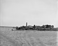
Lake Champlain, Crown Point Light between 1890 and 1910
-
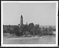
Crown Point Light, Lake Champlain, circa 1907
-
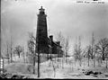
Crown Point Light House
-
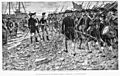
The Embarkation of Montgomery's Troops at Crown Point. Richard Montgomery and troops on shore at Crown Point, New York, en route for the invasion of Canada. Drawn by Sydney Adamson. Half-tone plate engraved by J.W. Evans. Printed 1902.
-
Ruins of Fort Crown Point, circa 1902
-
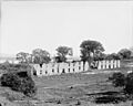
Ruins of Fort Crown Point, circa 1907
-
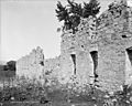
Ruins of Fort Crown Point, between 1900 and 1906
-
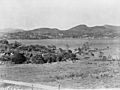
Port Henry from Fort St. Frédéric, Crown Point. Photograph shows view across Lake Champlain at hills in the distance on December 23, 1902.


See also
 In Spanish: Crown Point (Nueva York) para niños
